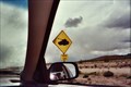
 view gallery view gallery SW6.1 km SW6.1 km
|   Tank Crossing - Ft. Irwin, California Tank Crossing - Ft. Irwin, California
in Uncommon Crossing Signs One of several "Tank Crossing" signs in the huge Fort Irwin training base in California. posted by:  LeoGeo LeoGeo location: California date approved: 04/20/2011 last visited: 04/18/2019 |
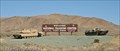
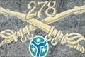 view gallery view gallerySW7.7 km |  Fort Irwin's Finest - Fort Irwin, CA Fort Irwin's Finest - Fort Irwin, CA
in Best Kept Secrets This location is truly a rare and unexpected sight. Everyone in our group marveled at what was here. Plan on spending some time looking around in both awe at the site as well as all the sacrifices of Fort Irwin's finest. posted by:  DopeyDuck DopeyDuck location: California date approved: 02/05/2009 last visited: 01/31/2009 |
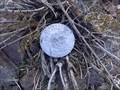
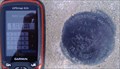
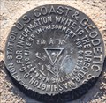
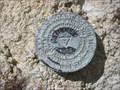 view gallery view gallery E12.1 km E12.1 km
|  FT1511 - Tiefort Mountain - San Bernadino County, CA FT1511 - Tiefort Mountain - San Bernadino County, CA
in U.S. Benchmarks Triangulation Station disk on top of Tiefort Mountain in the Mojave Desert. posted by: TheRadcliffs location: California date approved: 07/03/2014 last visited: 12/01/2016 |
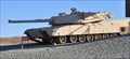 view gallery view gallerySW12.6 km |  M1 Abrams Main Battle Tank ~ Fort Irwin, California M1 Abrams Main Battle Tank ~ Fort Irwin, California
in Military Ground Equipment Displays This Military Ground Equipment Display is located at the main entrance to the Fort Irwin National Training Command in the Mohave Desert northeast of Barstow, California. posted by: brwhiz location: California date approved: 07/23/2013 last visited: never |
 view gallery view gallerySW12.6 km |  The National Training Center - Fort Irwin, CA The National Training Center - Fort Irwin, CA
in Military Installations Fort Irwin/The National Training Center is a major training area for the US Military. posted by: DopeyDuck location: California date approved: 02/02/2009 last visited: 05/24/2016 |
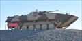 view gallery view gallerySW12.6 km | Soviet BMP-1 Tank in Military Ground Equipment Displays This Military Ground Equipment Display is located at the main entrance to the Fort Irwin National Training Command in the Mohave Desert northeast of Barstow, California. posted by: brwhiz location: California date approved: 07/23/2013 last visited: 07/24/2013 |
 view gallery view gallery NW12.7 km NW12.7 km
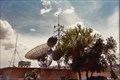
|  Echo Station, NASA Goldstone facility, Ft. Irwin, CA Echo Station, NASA Goldstone facility, Ft. Irwin, CA
in Weather Stations A weather station at Echo Station, the administrative headquarters of NASA's Goldstone deep-space tracking station. posted by: LeoGeo location: California date approved: 04/11/2011 last visited: never |
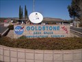
 view gallery view galleryNW12.9 km |  GOLDSTONE Letters on Hill - Fort Irwin, CA GOLDSTONE Letters on Hill - Fort Irwin, CA
in Letters on Hills It's pretty obvious when you're getting close to NASA's Goldstone Deep Space Network when you see these large letters . posted by: DopeyDuck location: California date approved: 02/02/2009 last visited: 04/08/2011 |
 view gallery view galleryNW12.9 km |  Goldstone from Above - Fort Irwin, CA Goldstone from Above - Fort Irwin, CA
in Readable From Above I wonder if the astronauts can see the letters on the hill behind NASA's Goldstone Deep Space Network complex? I bet Hubble or Voyager could. posted by: DopeyDuck location: California date approved: 09/05/2009 last visited: 04/08/2011 |
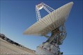 view gallery view galleryNW22.4 km |  Pioneer Deep Space Station - Fort Irwin, CA Pioneer Deep Space Station - Fort Irwin, CA
in U.S. National Register of Historic Places The Pioneer Antenna is the first of over 10 antenna at Goldstone which track the Mars Rovers, Hubble, Voyager, and over 30 other satellites in deep space. Access & free tours for the public can be arranged through their website. posted by: DopeyDuck location: California date approved: 02/03/2009 last visited: 01/31/2009 |
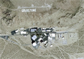
 view gallery view galleryNW27.5 km |  Goldstone Deep Space Communications Complex - Mojave Desert, CA Goldstone Deep Space Communications Complex - Mojave Desert, CA
in Wikipedia Entries The Goldstone Deep Space Communications Complex uses satellites to see what is in our galaxy. posted by: Gryffindor3 location: California date approved: 12/08/2009 last visited: never |
 view gallery view gallerySW28.3 km | LADWP L72F E114 Survey Point in U.S. Benchmarks A LADWP Survey Point posted by: Rumpled location: California date approved: 01/08/2008 last visited: never |
 view gallery view gallery S30.4 km S30.4 km
| Yermo RD Reference Mark MAN NO3 1964/1976 in U.S. Benchmarks Yermo RD Reference Mark Director National Geodetic Survey MAN NO 3 1964 1976. posted by: ghhs72 location: California date approved: 11/15/2012 last visited: 02/25/2014 |
 view gallery view galleryS30.6 km |  Mojave Desert Grade Crossing Mojave Desert Grade Crossing
in Active Rail Locations This Active Rail Location is a grade crossing for one of the many roads that lead off into the Mojave Desert east of Yermo, California. posted by: brwhiz location: California date approved: 08/28/2013 last visited: never |
 view gallery view galleryS30.6 km | EV3569 ~ MAN in U.S. Benchmarks This US Benchmark is a Triangulation Station disk located on the south side of the railroad tracks northeast of Yermo, California. posted by: brwhiz location: California date approved: 07/23/2013 last visited: never |
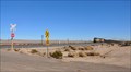
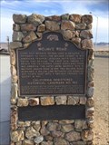
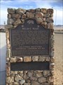
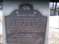
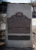
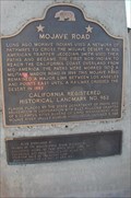 view gallery view gallery SE30.7 km SE30.7 km
|  Mojave Road - Newberry Springs, CA Mojave Road - Newberry Springs, CA
in California Historical Markers Long ago, Mohave Indians used a network of pathways to cross the Mojave Desert. In 1826, American trapper Jedediah Smith used their paths and became the first non-Indian to reach the California coast overland from mid-America.... posted by: JacobBarlow location: California date approved: 02/01/2008 last visited: 12/04/2015 |
 view gallery view gallerySE30.7 km |  FIRST -- Non-Indian to Reach the California Coast Overland From Mid-America - Newberry Springs, CA FIRST -- Non-Indian to Reach the California Coast Overland From Mid-America - Newberry Springs, CA
in First of its Kind A CA state marker at a rest area along interstate 15. posted by: bluesnote location: California date approved: 12/14/2015 last visited: 12/14/2015 |
 view gallery view gallerySE30.7 km | Mojave Road in Wikipedia Entries The Mojave Road is a historic off-road route across the Mojave National Preserve. The road served westward travelers in the 1800s by leading them between watering holes across the Mojave Desert. posted by: JacobBarlow location: California date approved: 01/22/2008 last visited: 12/04/2015 |
 view gallery view gallerySE30.7 km |  Mojave Road - Newberry Springs, CA Mojave Road - Newberry Springs, CA
in Cairns A CA state marker at a rest area along interstate 15. posted by: bluesnote location: California date approved: 02/19/2022 last visited: never |
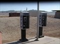 view gallery view gallerySE30.7 km |  Mojave Road Phones - Mojave Desert, California Mojave Road Phones - Mojave Desert, California
in Payphones These phones are at a rest stop about 30 miles north of Barstow on California's Interstate 15. posted by: Metro2 location: California date approved: 11/21/2009 last visited: 02/13/2011 |
 view gallery view gallerySE30.7 km |  Mojave Road -- Mojave Desert, California Mojave Road -- Mojave Desert, California
in Wagon Roads and Trails This California Historic Landmark is located in the desert at a rest stop along I-15 North on the way to Las Vegas...and marks the Indian trails which eventually were used as wagon roads...and now an Interstate Highway.
posted by: Metro2 location: California date approved: 11/21/2009 last visited: 12/04/2015 |
 view gallery view gallerySE30.7 km |  Mojave Road - California Mojave Road - California
in E Clampus Vitus Historical Markers This California Historic Landmark is located in the desert at a rest stop along I-15 North on the way to Las Vegas. posted by: Metro2 location: California date approved: 11/20/2009 last visited: 12/04/2015 |
 view gallery view gallerySE30.7 km |  Mojave Road - Mojave Desert, California Mojave Road - Mojave Desert, California
in Ancient Traces and Roads This California Historic Landmark is located in the desert at a rest stop along I-15 North on the way to Las Vegas...and marks the Indian trails which eventually were used as wagon roads...and now an Insterstate Highway.
posted by: Metro2 location: California date approved: 11/21/2009 last visited: 12/04/2015 |
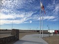 view gallery view gallerySE30.7 km |  Clyde V. Kane Northbound Rest Area - Newberry Springs, CA Clyde V. Kane Northbound Rest Area - Newberry Springs, CA
in Free Overnight RV Parking Locations A newly refurbished rest area along Interstate 15. posted by: bluesnote location: California date approved: 02/20/2016 last visited: 02/20/2016 |
 view gallery view gallerySE30.7 km |  Clyde V. Kane Northbound Rest Area - Newberry Springs, CA Clyde V. Kane Northbound Rest Area - Newberry Springs, CA
in Highway Rest Areas A newly refurbished rest area along Interstate 15. posted by: bluesnote location: California date approved: 12/16/2015 last visited: 12/16/2015 |
|