 view gallery view gallery NE0.6 km NE0.6 km
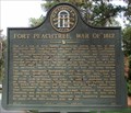
|   Fort Peachtree, War of 1812 - GHM 060-194 – Fulton Co., GA Fort Peachtree, War of 1812 - GHM 060-194 – Fulton Co., GA
in Georgia Historical Markers Fort Peachtree, War of 1812 State Historical Marker located on the east side of Ridgewood Rd at Ridgewood Circle, Atlanta, GA. posted by:  Lat34North Lat34North location: Georgia date approved: 11/12/2007 last visited: 10/31/2000 |
 view gallery view galleryNE0.6 km |  Fort Peachtree, War of 1812 - Atlanta, GA Fort Peachtree, War of 1812 - Atlanta, GA
in War of 1812 Fort Peachtree, War of 1812 State Historical Marker located on the east side of Ridgewood Rd at Ridgewood Circle, Atlanta, GA. posted by: Lat34North location: Georgia date approved: 10/26/2008 last visited: 10/26/2008 |
 view gallery view gallery S0.8 km S0.8 km
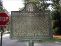
| The Montgomery-DeFoor House Site GHM 060-63 in Georgia Historical Markers At Moore's Mill and Bolton Rds. posted by:  Markerman62 Markerman62 location: Georgia date approved: 05/18/2015 last visited: 04/03/2003 |
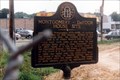
 view gallery view galleryS1 km | Montgomery Cemetery - GHM 060-190 - Fulton Co., GA in Georgia Historical Markers Montgomery Cemetery state historic marker locate on west side of Marietta Blvd 1-4 mile south of Bolton Rd, Atlanta. The marker is off the shoulder in the trees and is not easily visible from the road. posted by: Lat34North location: Georgia date approved: 05/13/2009 last visited: 02/07/2014 |
 view gallery view gallery SW1 km SW1 km
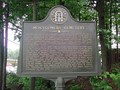
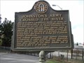
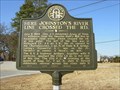
| Johnston's Army Crossed the River - GHM 060-85 – Fulton Co., GA. in Georgia Historical Markers Johnston's Army Crossed the River State Historical Marker located Nixon and Marietta Rd, Bolton, Atlanta, GA. posted by: Lat34North location: Georgia date approved: 11/12/2007 last visited: 02/20/2010 |
 view gallery view galleryS1 km |  Montgomery Cemetery Montgomery Cemetery
in Abandoned Cemeteries This cemetery is located in an industrial section of Atlanta and is the final resting place of Major Montgomery, probably the first white settler in Fulton County. posted by: Buckhead Heritage Society location: Georgia date approved: 02/20/2008 last visited: 05/13/2009 |
 view gallery view gallery E1.1 km E1.1 km
|  DeKalb Co, Ga. Station 645 DeKalb Co, Ga. Station 645
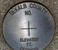
in U.S. Benchmarks DeKalb Co. staion number 645 located on Buford Hwy, south of N. Druid Hills Rd., at the bridge across the north fork of Peachtree Creek posted by: Lat34North location: Georgia date approved: 07/10/2007 last visited: never |
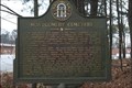
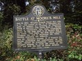 view gallery view galleryE1.1 km | Battle at Moore’s Mill - GHM 060-65 – Fulton Co., GA. in Georgia Historical Markers Battle at Moore’s Mill State Historical Marker located on the north side of Moores Mill Road east of Peachtree Creek, Atlanta, GA. posted by: Lat34North location: Georgia date approved: 11/12/2007 last visited: 10/31/2000 |
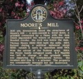 view gallery view galleryE1.1 km | Moore’s Mill - GHM 060-64 – Fulton Co., GA. in Georgia Historical Markers Moore’s Mill State Historical Marker located on the north side of Moores Mill Road east of Peachtree Creek, Atlanta, GA. posted by: Lat34North location: Georgia date approved: 11/12/2007 last visited: 10/31/2000 |
 view gallery view gallery NW1.8 km NW1.8 km
| Here Johnston's River Line Crossed the Road-GHM 033-079-Cobb Co in Georgia Historical Markers South Atlanta Rd at Plant Adkinson Rd. South of I-285 posted by: Sprinterman location: Georgia date approved: 02/21/2010 last visited: 07/31/2000 |
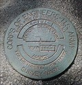 view gallery view galleryNE1.8 km | Corp of Engineering 4 TML 1 – W Wesley Road, Atlanta, GA in U.S. Benchmarks US Army Corp of Engineering Survey mark located on W Wesley Road on the South East end of the bridge over Nancy Creek, Atlanta, GA. posted by: Lat34North location: Georgia date approved: 10/27/2007 last visited: never |
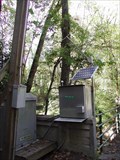 view gallery view galleryNE1.8 km |  Nancy Creek at West Wesley Road, Atlanta, GA. Nancy Creek at West Wesley Road, Atlanta, GA.
in River Gauges Located on the South East side of the bridge over Nancy Creek on West Wesley Drive. posted by: Lat34North location: Georgia date approved: 11/03/2007 last visited: 11/03/2007 |
 view gallery view gallery SE2.1 km SE2.1 km
| Hanover West-Atlanta, GA (Buckhead) in Abandoned Cemeteries Located in an Atlanta residential neighborhood, this abandoned cemetery has two marked graves dating to 1911 and 1916. posted by: Buckhead Heritage Society location: Georgia date approved: 02/19/2008 last visited: never |
 view gallery view gallerySE2.1 km |  Crestlawn Veterans Memorial - Atlanta, GA Crestlawn Veterans Memorial - Atlanta, GA
in Non-Specific Veteran Memorials This memorial to all veterans is located on a hill top in Crestlawn Cemetery on Chattahoochee Ave in Atlanta, GA. posted by: Lat34North location: Georgia date approved: 03/14/2012 last visited: 05/30/2005 |
 view gallery view galleryS2.1 km |  Casey's Hill Casey's Hill
in Your Name Here Casey's Hill Marker posted by: ILuvAZ location: Georgia date approved: 06/06/2013 last visited: 05/12/2020 |
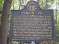 view gallery view galleryS2.1 km | Casey's Hill - GHM 060-86 Fulton County in Georgia Historical Markers Casey's Hill State Historical Marker
Located at the west edge of Crestlawn Cemetery on Old Atlanta-Marietta Rd. in Atlanta
posted by: GA Cacher location: Georgia date approved: 10/07/2007 last visited: 10/31/2000 |
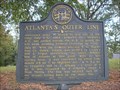 view gallery view galleryS2.3 km | Atlanta's Outer Line GHM 060-87, Fulton County in Georgia Historical Markers Atlanta's Outer Line State Historical Marker
Located at the west edge of Crestlawn Cemetery on Old Atlanta-Marietta Rd. in Atlanta
posted by: GA Cacher location: Georgia date approved: 10/07/2007 last visited: 10/31/2000 |
 view gallery view gallerySE2.3 km |  Lena Fox " Miss Daisy" of "Driving Misss Daisy" Lena Fox " Miss Daisy" of "Driving Misss Daisy"
in Grave of a Famous Person Crestlawn Cemetery Atlanta GA grave of Lena Fox posted by: GA Cacher location: Georgia date approved: 04/10/2007 last visited: 03/23/2011 |
 view gallery view gallerySE2.4 km |  Crestlawn Memorial Park - Atlanta , GA Crestlawn Memorial Park - Atlanta , GA
in Worldwide Cemeteries Crest Lawn Memorial Park was established as a public burial place in 1916.Situated on approximately 145 acres, replete with rolling hills and established trees, Crest Lawn provides a tranquil place to honor the memory of loved ones. posted by: GA Cacher location: Georgia date approved: 07/29/2008 last visited: 05/30/2005 |
 view gallery view galleryE2.4 km | Green Bone Creek - GHM 060-54 - Fulton Co., GA in Georgia Historical Markers A small tributary of Peachtree Creek, which rises near Pace’s Ferry Road & drains the valley between Arden, Dover, Howell Mill rds. & Moore’s Mill Road; a landmark of military operations in the Summer of 1864.
posted by: Lat34North location: Georgia date approved: 10/09/2007 last visited: 10/31/2000 |
 view gallery view galleryE2.7 km |  Carl E. Sanders Family YMCA at Buckhead Carl E. Sanders Family YMCA at Buckhead
in YMCA / YWCA This modern and huge YMCA is located just off I-75 at Moores Mill Rd. on the North edge of Atlanta. posted by: Sprinterman location: Georgia date approved: 07/17/2008 last visited: 07/18/2008 |
 view gallery view gallery W2.7 km W2.7 km
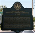
| Collins Springs Primitive Baptist Church c. 1866 - Cobb Co., GA in Georgia Historical Markers The Collins Springs Primitive Baptist Church c. 1866 historic marker is located next to the old church at 4775 North Church Lane at Collins Springs Lane. The church is now the Atlanta Freethought Society. posted by: Lat34North location: Georgia date approved: 07/24/2010 last visited: 01/02/2013 |
 view gallery view galleryW2.7 km |  Collins Springs Cemetery - North Church Lane - Atlanta, GA Collins Springs Cemetery - North Church Lane - Atlanta, GA
in Churchyard Cemeteries The Collins Springs Cemetery is located on North Church Lane at Collins Springs Lane. The old church is located across the street and is now the Atlanta Freethought Society. There are 800 to 1,000 headstones in this cemetery. posted by: Lat34North location: Georgia date approved: 07/22/2010 last visited: 01/02/2013 |
 view gallery view galleryW2.7 km | Collins Springs Cemetery - Atlanta, GA in Worldwide Cemeteries The Collins Springs Cemetery is located on North Church Lane at Collins Springs Lane. The old church is located across the street and is now the Atlanta Freethought Society. There are 800 to 1,000 headstones in this cemetery. posted by: Lat34North location: Georgia date approved: 07/23/2010 last visited: 01/02/2013 |
 view gallery view galleryNW2.7 km |  Subway # 25163 - S Atlanta Rd - Smyrna, GA Subway # 25163 - S Atlanta Rd - Smyrna, GA
in Subway Restaurants This Subway is attached, but separate, to a Texaco Food Mart. It is located on S Atlanta Rd SE, east of I-285 in Smyrna, GA 30080. posted by: Lat34North location: Georgia date approved: 03/14/2012 last visited: 01/02/2013 |
|