
Fort Peachtree, War of 1812 - GHM 060-194 – Fulton Co., GA
Posted by:  Lat34North
N 33° 49.881 W 084° 26.941
16S E 736072 N 3746383
Fort Peachtree, War of 1812 State Historical Marker located on the east side of Ridgewood Rd at Ridgewood Circle, Atlanta, GA.
Waymark Code: WM2JG7
Location: Georgia, United States
Date Posted: 11/11/2007
Views: 181
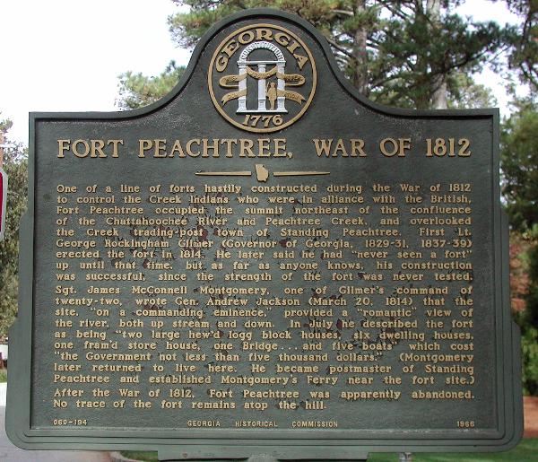 FORT PEACHTREE, WAR OF 1812
One of a line of forts hastily constructed during the war of 1812 to control the Creek Indians who were in alliance with the British. Fort Peachtree occupied the summit northeast of the confluence of the Chattahoochee River and Peachtree Creek, and overlooked the Creek trading Post town of Standing Peachtree. First Lt. George Rockingham Gilmer (Governor of Georgia, 1829-31, 1837-39) erected the fort in 1814. He later said he had “never seen a fort” up until that time, but as far as anyone knows, his construction was successful, since the strength of the fort was never tested. Sgt James McConnell Montgomery, one of Gilmer’s command of twenty-two wrote Gen. Andrew Jackson (March20, 1814) that the site, “on a commanding eminence,” provided a “romantic” view of the river, both up stream and down. In July he described the fort as being “two large hew’s logg block houses, six dwelling houses, and one fram’d store hose, one Bridge .. . and five boats” which cost “the Governor not less the five thousand dollars”. (Montgomery later returned to live here. He became postmaster of Standing Peachtree and established Montgomery’s Ferry near the fort site.) After the War of 1812, Fort Peachtree was apparently abandoned. No trace of the fort remains atop the hill.
This marker is located in the font yard of a home. Please be respectful of their property.
GHM 060-194 - Georgia Historical Commission - 1966