 view gallery view gallery NE4.3 km NE4.3 km
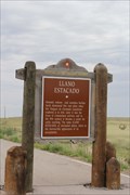
|   Llano Estacado -- nr Caprock NM Llano Estacado -- nr Caprock NM
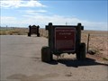
in New Mexico Historical Markers A New Mexico state historic marker along the US 380 near Caprock NM posted by:  Benchmark Blasterz Benchmark Blasterz location: New Mexico date approved: 09/11/2014 last visited: 07/04/2018 |
 view gallery view gallery NW6.3 km NW6.3 km
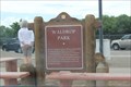
| Waldrop Park -- US380 rest area nr Chaves Co. Line, NM in New Mexico Historical Markers A historic marker in a small but clean rest area on the US 380 jst west of the Chaves County line. posted by: Benchmark Blasterz location: New Mexico date approved: 09/11/2014 last visited: 05/29/2020 |
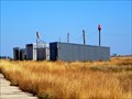
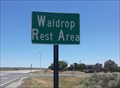 view gallery view galleryNW6.3 km |  Waldrop Rest Area - east of Roswell, NM Waldrop Rest Area - east of Roswell, NM
in Highway Rest Areas A well-appointed rest stop on the south side of U.S. Highway 380 between Roswell and Caprock, New Mexico posted by: The Snowdog location: New Mexico date approved: 07/25/2020 last visited: never |
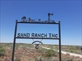 view gallery view galleryNW6.3 km |  Sand Ranch - east of Roswell, NM Sand Ranch - east of Roswell, NM
in Silhouette Public Art Sculptures The entry sign to the Sand Ranch incorporates silhouette art of prairie life; east of Roswell, New Mexico posted by: The Snowdog location: New Mexico date approved: 07/23/2020 last visited: never |
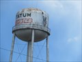 view gallery view gallery E44.1 km E44.1 km
|  Water Tower - Tatum NM Water Tower - Tatum NM
in Water Towers This Water Tower is just northwest of the junction of US Hwy 380 and NV Hwy 206 in Tatum, New Mexico. posted by: PeterNoG location: New Mexico date approved: 10/05/2017 last visited: 04/25/2019 |
 view gallery view galleryE44.3 km |  Tatum, New Mexico Tatum, New Mexico
in Wikipedia Entries Tatum is a census designated location in eastern New Mexico. posted by: rjmcdonough1 location: New Mexico date approved: 10/28/2021 last visited: never |
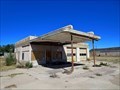 view gallery view galleryE44.3 km |  Abandoned Station - Tatum, NM Abandoned Station - Tatum, NM
in Vintage Gas Stations Sometime after closure, this station was entirely spray painted tan. posted by: rjmcdonough1 location: New Mexico date approved: 10/26/2021 last visited: never |
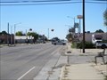
 view gallery view gallery SW45.4 km SW45.4 km
|  Suzanne Road Suzanne Road
in Your Name Here Suzanne Road sign posted by: siff location: New Mexico date approved: 10/16/2021 last visited: 10/16/2021 |
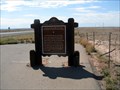
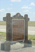 view gallery view galleryE45.9 km | Lea County Cowgirls -- US380 nr Tatum NM in New Mexico Historical Markers A historic marker on US380 near Tatum commemorates Dessie and Fern Sawyer, Lea County Cowgirls of yore. posted by: Benchmark Blasterz location: New Mexico date approved: 09/11/2014 last visited: 07/04/2018 |
 view gallery view galleryE47.5 km | Tatum Airport - Tatum NM in Wikipedia Entries The Tatum Municipal Airport consists of two runways and a few sheds. posted by: rjmcdonough1 location: New Mexico date approved: 11/02/2021 last visited: never |
 view gallery view galleryE47.5 km |  Tatum Airport - Tatum NM Tatum Airport - Tatum NM
in Airports The Tatum Municipal Airport consists of two runways and a few sheds. posted by: rjmcdonough1 location: New Mexico date approved: 11/02/2021 last visited: never |
 view gallery view gallery W50.2 km W50.2 km
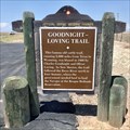
|  Goodnight-Loving Trail - Roswell, NM, USA Goodnight-Loving Trail - Roswell, NM, USA
in Wagon Roads and Trails US 380 crosses the Goodnight-Loving Trail in this vicinity. posted by: QuesterMark location: New Mexico date approved: 10/13/2018 last visited: 07/04/2018 |
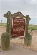 view gallery view galleryW50.2 km | Goodnight-Loving Trail -- US 380 nr the Pecos River, E of Roswell NM in New Mexico Historical Markers A historic marker for the Goodnight-Loving cattle drive trail east of Roswell on the US 380 near its crossing of the Pecos River posted by: Benchmark Blasterz location: New Mexico date approved: 09/11/2014 last visited: 07/04/2018 |
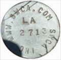 view gallery view galleryNW51 km |  SWCA LA 2713 SWCA LA 2713
in U.S. Benchmarks BENCHMARK SWCA LA 2713 posted by:  GEO*Trailblazer 1 GEO*Trailblazer 1 location: New Mexico date approved: 01/01/2007 last visited: 01/01/2007 |
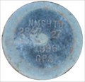 view gallery view galleryNW51 km | NMSHTD 2847 27 1996 GPS in U.S. Benchmarks NEW MEXICO STATE HIGHWAY TRANSPORTATION DEPARTMENT 2847 27 posted by: GEO*Trailblazer 1 location: New Mexico date approved: 01/01/2007 last visited: 01/01/2007 |
 view gallery view galleryW52.5 km |  Mirror Lake, near Roswell, New Mexico Mirror Lake, near Roswell, New Mexico
in Places of Geologic Significance Mirror Lake is actually a set of 2 lakes, with an unusual difference between the two! posted by: Queens Blessing location: New Mexico date approved: 11/06/2011 last visited: 09/02/2013 |
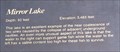 view gallery view galleryW52.5 km |  Mirror Lake at 3,483 feet, New Mexico Mirror Lake at 3,483 feet, New Mexico
in Elevation Signs This location, in the desert, is 3,483 feet above sea level. posted by: Queens Blessing location: New Mexico date approved: 11/05/2011 last visited: 09/02/2013 |
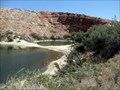
 view gallery view galleryW52.5 km |  Bottomless Lakes State Parks - New Mexico Bottomless Lakes State Parks - New Mexico
in State/Provincial Parks Cowboys were unsuccessful in determining the depth of these lakes when tying boulders on their lassos and dropping them into the lake, creating legends that these lakes are bottomless. posted by: Queens Blessing location: New Mexico date approved: 11/05/2011 last visited: 06/21/2013 |
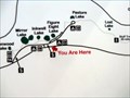 view gallery view galleryW52.5 km |  Devil's Inkwell at Bottomless Lakes State Parks, New Mexico Devil's Inkwell at Bottomless Lakes State Parks, New Mexico
in 'You Are Here' Maps Cowboys were unsuccessful in determining the depth of these lakes when tying boulders on their lassos and dropping them into the lake, creating legends that these lakes are bottomless. posted by: Queens Blessing location: New Mexico date approved: 11/05/2011 last visited: 09/02/2013 |
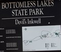 view gallery view galleryW52.5 km |  Devil's Inkwell, New Mexico Devil's Inkwell, New Mexico
in Geological Devilish Locations This murky looking lake is called Devil's Inkwell. posted by: Queens Blessing location: New Mexico date approved: 11/16/2011 last visited: 09/15/2012 |
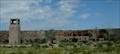 view gallery view galleryW52.6 km |  Bathhouse & Pavilion, Bottomless Lakes State Park, New Mexico Bathhouse & Pavilion, Bottomless Lakes State Park, New Mexico
in Civilian Conservation Corps The bathhouse and pavilion at Bottomless Lakes State Park were built in 1935-38 by the CCC. posted by: Queens Blessing location: New Mexico date approved: 11/07/2011 last visited: 09/15/2012 |
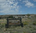
 view gallery view galleryW52.6 km |  FIRST State Park in New Mexico- Bottomless Lakes FIRST State Park in New Mexico- Bottomless Lakes
in Superlatives This was the FIRST State Park established in the state of New Mexico. posted by: Queens Blessing location: New Mexico date approved: 11/06/2011 last visited: 06/21/2013 |
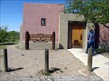
 view gallery view galleryW53.6 km | Bottomless Lakes State Park, New Mexico in New Mexico Historical Markers This historical marker is located at the Junction of highway 380 & Co Rd 409, east of Roswell posted by: Queens Blessing location: New Mexico date approved: 11/05/2011 last visited: 07/04/2018 |
 view gallery view galleryW53.6 km | Louise Massey Mabie , New Mexico in New Mexico Historical Markers This historical marker is located at the Junction of highway 380 & Co Rd 409, east of Roswell. posted by: Queens Blessing location: New Mexico date approved: 11/05/2011 last visited: 07/04/2018 |
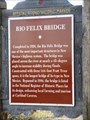 view gallery view gallerySW59.2 km | Rio Felix Bridge - Hagerman, NM in New Mexico Historical Markers The Rio Felix Bridge in Hagerman, NM. posted by: saopaulo1 location: New Mexico date approved: 12/21/2016 last visited: never |
|