 view gallery view gallery SE1.4 km SE1.4 km
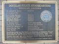
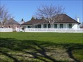
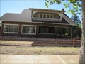
|   Douglas Police Headquarters Douglas Police Headquarters
in Arizona Historical Markers Built as the El Paso & Southwestern Railroad Depot, the two story Beaux Arts Classic Revival style depot saw as many as eight passenger trains a day in the 1920's. posted by:  leadhiker leadhiker location: Arizona date approved: 05/17/2010 last visited: 06/15/2012 |
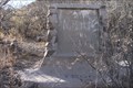
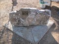
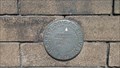 view gallery view gallerySE1.4 km |  US Geological Survey B.M. CF0142 - Douglas, Az. US Geological Survey B.M. CF0142 - Douglas, Az.
in U.S. Benchmarks US Geological Survey B.M. located at the Douglas, Az. Police Department. posted by:  outwest63 outwest63 location: Arizona date approved: 10/31/2013 last visited: never |
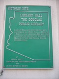 view gallery view gallerySE2.1 km | Library Hall the Douglas Public Library in Arizona Historical Markers This was one of the first buildings in Douglas. It has been in continuous use for over 80 years and moved twice. The first time it was moved was from Pan American & 10th St. to 10th St. and F Ave. The last move was to make room for the Post Office. posted by: leadhiker location: Arizona date approved: 05/17/2010 last visited: never |
 view gallery view gallery E5.5 km E5.5 km
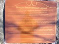
| Douglas International Airport in Arizona Historical Markers The first and only truly international airport in the America's, Douglas International Airport began operations in 1929. The Douglas airfield was connected with the Auga Prieta, Mexico, airport by a common north-south runway. posted by: leadhiker location: Arizona date approved: 05/17/2010 last visited: never |
 view gallery view gallery W14.3 km W14.3 km
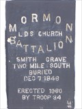
| Mormon Battalion in Arizona Historical Markers The Mormon Battalion was the only religious unit in American military history, serving from July 1846 to July 1847 during the Mexican-American War. The battalion made a grueling 2000 mile march from Council Bluffs, Iowa to San Diego, California. posted by: leadhiker location: Arizona date approved: 05/14/2010 last visited: 04/05/2011 |
 view gallery view galleryW20.3 km | International Boundary Monument 89 in U.S. Benchmarks International Boundary Monument 89 posted by: outwest63 location: Arizona date approved: 04/06/2011 last visited: never |
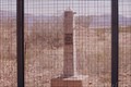 view gallery view galleryW24.1 km | International Boundary Marker 90 in U.S. Benchmarks International Boundary Marker Number 90 posted by: outwest63 location: Arizona date approved: 04/06/2011 last visited: never |
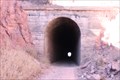 view gallery view galleryW24.6 km |  El Paso and Southwestern Bisbee Tunnel (Crook Tunnel) El Paso and Southwestern Bisbee Tunnel (Crook Tunnel)
in Abandoned Train Tunnels The tunnel was built by the El Paso and Southwestern in 1902. posted by: outwest63 location: Arizona date approved: 02/02/2011 last visited: 06/30/2020 |
 view gallery view galleryE26.4 km | Mormon Battalion in Arizona Historical Markers The Mormon Battalion was the only religious unit in American military history, serving from July 1846 to July 1847 during the Mexican-American War. The battalion made a grueling 2000 mile march from Council Bluffs, Iowa to San Diego, California. posted by: leadhiker location: Arizona date approved: 05/14/2010 last visited: 01/26/2011 |
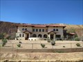
 view gallery view galleryE27.4 km |  San Bernardino Ranch - Douglas, AZ San Bernardino Ranch - Douglas, AZ
in U.S. National Register of Historic Places Much history abounds in this Old West which really has not changed all that much. It is still remote, laid-back and beautiful, as it separates itself from the hectic life of the big city. posted by: leadhiker location: Arizona date approved: 05/17/2010 last visited: never |
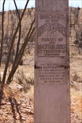
 view gallery view galleryE28.8 km | Mormon Batallion Passed Here in Arizona Historical Markers The Mormon Battalion was activated on July 1846 to assist in the war with Mexico. They traveled from Council Bluffs, Iowa to San Diego, California. The Battalion was deactivated in July, 1847. posted by: outwest63 location: Arizona date approved: 02/06/2011 last visited: never |
 view gallery view galleryW30.3 km | Douglas, Walter, House - Bisbee, Arizona in U.S. National Register of Historic Places Historic former home of mining company executive in Bisbee, Arizona posted by:  BruceS BruceS location: Arizona date approved: 07/03/2013 last visited: never |
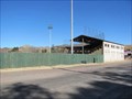 view gallery view galleryW30.3 km |  OLDEST - Ballpark in Arizona - Bisbee, AZ OLDEST - Ballpark in Arizona - Bisbee, AZ
in Superlatives The Warren Ballpark, dating from 1906 is the oldest in the state. posted by: linkys location: Arizona date approved: 12/25/2009 last visited: 05/27/2014 |
 view gallery view galleryW30.3 km |  Warren Ballpark - Bisbee, AZ Warren Ballpark - Bisbee, AZ
in Amateur Baseball Fields The oldest ballfield in the state of Arizona and one of the oldest, if not the oldest in the country. posted by: linkys location: Arizona date approved: 12/23/2009 last visited: 05/27/2014 |
 view gallery view galleryW30.3 km |  Warren Ballpark Warren Ballpark
in Wikipedia Entries Stadium located in Bisbee, Arizona, built in 1909 by Phelps Dodge mining company as a recreation facility for miners and their families posted by: linkys location: Arizona date approved: 12/22/2009 last visited: 05/03/2014 |
 view gallery view galleryW30.3 km |  Bisbee Farmers Market - Bisbee, AZ Bisbee Farmers Market - Bisbee, AZ
in Farmers' Markets Where local farmers and handcrafters sell their home-grown and hand-made products. posted by: linkys location: Arizona date approved: 12/26/2009 last visited: 05/03/2014 |
 view gallery view galleryW30.3 km |  Time Capsule - Bisbee, AZ Time Capsule - Bisbee, AZ
in Time Capsules Placed as part of the Warren centennial celebration in 2006. posted by: linkys location: Arizona date approved: 12/22/2009 last visited: 01/09/2015 |
 view gallery view galleryW30.4 km | Treu, John, House - Bisbee, Arizona in U.S. National Register of Historic Places Historic Arts and Crafts style bungalow in Bisbee, Arizona. posted by: BruceS location: Arizona date approved: 07/02/2013 last visited: never |
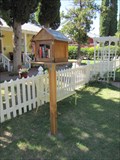 view gallery view galleryW30.4 km |  Helen's Little Library - Bisbee, Arizona Helen's Little Library - Bisbee, Arizona
in Free Community Book Exchanges Little library in community of Bisbee, Arizona. posted by: BruceS location: Arizona date approved: 03/07/2014 last visited: 05/04/2014 |
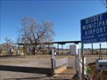 view gallery view galleryW30.4 km |  Bisbee Municipal Airport - Bisbee, AZ Bisbee Municipal Airport - Bisbee, AZ
in Airports Small airport serving the town of Bisbee and the surrounding areas of Cochise County. posted by: linkys location: Arizona date approved: 01/07/2010 last visited: 08/18/2013 |
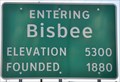 view gallery view galleryW30.4 km |  Bisbee, Arizona (Northeastern Approach) ~ Elevation 5300 Feet Bisbee, Arizona (Northeastern Approach) ~ Elevation 5300 Feet
in Elevation Signs This Elevation Sign is located on the north side of Arizona Highway 80 at the northeastern city limit of Bisbee, Arizona. posted by: brwhiz location: Arizona date approved: 02/12/2013 last visited: never |
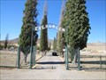 view gallery view galleryW31.7 km | Evergreen Cemetery - Bisbee, Arizona in U.S. National Register of Historic Places Historic cemetery in Lowell suburb of Bisbee, Arizona. posted by: BruceS location: Arizona date approved: 07/03/2013 last visited: 07/13/2014 |
 view gallery view galleryW31.7 km |  Evergreen Cemetery - Bisbee, Arizona Evergreen Cemetery - Bisbee, Arizona
in Worldwide Cemeteries Historic cemetery the Lowell area of Bisbee, Arizona. posted by: BruceS location: Arizona date approved: 07/05/2013 last visited: 01/23/2020 |
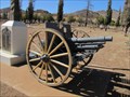 view gallery view galleryW31.7 km |  3-inch M1902 Field Gun - Bisbee, Arizona 3-inch M1902 Field Gun - Bisbee, Arizona
in Static Artillery Displays Towed artillery gun built in the early twentieth century, now part of veterans memorial at Evergreen Cemetery in Bisbee, Arizona. posted by: BruceS location: Arizona date approved: 07/15/2013 last visited: 01/23/2020 |
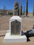 view gallery view galleryW31.7 km |  Bisbee World War II Memorial - Bisbee, Arizona Bisbee World War II Memorial - Bisbee, Arizona
in World War II Memorials / Monuments World War II memorial located at Evergreen Cemetery in Bisbee, Arizona. posted by: BruceS location: Arizona date approved: 07/04/2013 last visited: 07/13/2014 |
|