 view gallery view gallery N67.8 km N67.8 km
|   Continental Divide US Southernmost Pt N 31° 29' 49.9" W 108° 12' 31.8 Continental Divide US Southernmost Pt N 31° 29' 49.9" W 108° 12' 31.8
in Permanent Geographic Coordinates Continental Divide US Southernmost Point Monument posted by:  philbeer philbeer location: New Mexico date approved: 07/09/2021 last visited: 07/20/2021 |
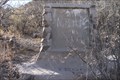
 view gallery view galleryN67.8 km |  Continental Divide US Southernmost Point Continental Divide US Southernmost Point
in Watershed Markers and Monuments Continental Divide US Southernmost Point posted by: philbeer location: New Mexico date approved: 07/07/2021 last visited: 07/09/2021 |
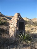
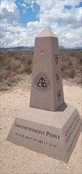 view gallery view galleryN67.8 km |  Continental Divide US Southernmost Point Obelisk Continental Divide US Southernmost Point Obelisk
in Obelisks Continental Divide US Southernmost Point Obelisk posted by: philbeer location: New Mexico date approved: 07/09/2021 last visited: 07/10/2021 |
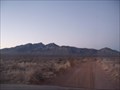 view gallery view galleryN85.5 km |  Big Hatchet Peak Big Hatchet Peak
in Mountain Summits The highest point in the Big Hatchet Mountains at 8,363 feet and the top ranking mountain (according to spire measure) in New Mexico. It's also the second highest point in Hidalgo County, but the highest point that has public access. posted by: Aberwak location: New Mexico date approved: 04/24/2008 last visited: never |
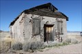 view gallery view gallery NW91.1 km NW91.1 km
|  Cloverdale, New Mexico Cloverdale, New Mexico
in Ghost Towns Cloverdale, New Mexico townsite posted by: outwest63 location: New Mexico date approved: 02/28/2012 last visited: never |
 view gallery view galleryNW106.2 km |  U.S. Mormon Battalion Trail Historical Marker No. 7 U.S. Mormon Battalion Trail Historical Marker No. 7
in New Mexico Historical Markers Historical Marker No. 7
U. S. Mormon Battalion Trail
History of Trek Though Mountains
Located on Geronimo Trail in South West Hidalgo County New Mexico posted by: outwest63 location: New Mexico date approved: 02/26/2012 last visited: 11/07/2017 |
 view gallery view galleryNW106.2 km |  Mormon Battalion Trail Marker No. 7 Mormon Battalion Trail Marker No. 7
in Smithsonian Art Inventory Sculptures The Mormon Battalion Trail Marker No. 7 is a Wood and Stone monument located on the Geronimo Trail. The marker is in Hidalgo County, New Mexico South of Annimas, New Mexico posted by: outwest63 location: New Mexico date approved: 03/22/2012 last visited: 11/07/2017 |
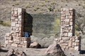
 view gallery view galleryNW106.4 km |  NM / AZ on Geronimo Trail NM / AZ on Geronimo Trail
in Border Crossings A 2 meter high stone and mortar monument with a bronze plaque on a remote dirt road in the beautiful Hog Canyon in the rugged deep southwest of New Mexico; deep southeast of Arizona. posted by: Scrawlinn location: New Mexico date approved: 04/21/2009 last visited: 11/07/2017 |
 view gallery view gallery NE113 km NE113 km
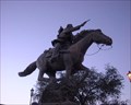
|  Presidencia Seccional Patricio Martinez Garcia Presidencia Seccional Patricio Martinez Garcia
in Equestrian Statues This horse and rider statue is located in the Mexican bordertown of Palomas, Mexico, just south of Columbus, New Mexico. posted by: rilekyle location: Mexico date approved: 10/23/2006 last visited: 11/03/2010 |
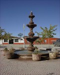 view gallery view galleryNE113 km |  The Pink Store courtyard fountain The Pink Store courtyard fountain
in Fountains This fountain is located outside of the Pink Store in Palomas, Mexico, just across the border from Columbus, New Mexico. posted by: rilekyle location: Mexico date approved: 10/23/2006 last visited: 03/22/2008 |
 view gallery view galleryNW114.7 km |  Mormon Batallion Passed Here Mormon Batallion Passed Here
in Arizona Historical Markers The Mormon Battalion was activated on July 1846 to assist in the war with Mexico. They traveled from Council Bluffs, Iowa to San Diego, California. The Battalion was deactivated in July, 1847. posted by: outwest63 location: Arizona date approved: 02/06/2011 last visited: never |
 view gallery view galleryNW115.1 km |  San Bernardino Ranch - Douglas, AZ San Bernardino Ranch - Douglas, AZ
in U.S. National Register of Historic Places Much history abounds in this Old West which really has not changed all that much. It is still remote, laid-back and beautiful, as it separates itself from the hectic life of the big city. posted by:  leadhiker leadhiker location: Arizona date approved: 05/17/2010 last visited: never |
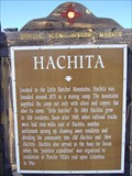 view gallery view galleryN115.4 km | Hachita in New Mexico Historical Markers A New Mexico OSHM along NM Hwy 9 at milepost 146. posted by: leadhiker location: New Mexico date approved: 06/17/2011 last visited: 07/05/2021 |
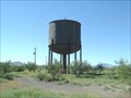 view gallery view galleryN115.4 km |  HATCHITA - Water Tank HATCHITA - Water Tank
in Water Towers Hatchita New Mexico Rail Road Water Tank posted by: GEO*Trailblazer 1 location: New Mexico date approved: 01/07/2007 last visited: 07/05/2021 |
 view gallery view galleryNW116 km | Mormon Battalion in Arizona Historical Markers The Mormon Battalion was the only religious unit in American military history, serving from July 1846 to July 1847 during the Mexican-American War. The battalion made a grueling 2000 mile march from Council Bluffs, Iowa to San Diego, California. posted by: leadhiker location: Arizona date approved: 05/14/2010 last visited: 01/26/2011 |
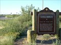
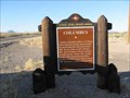 view gallery view galleryNE116.2 km | Columbus in New Mexico Historical Markers When Pancho Villa attacked Columbus during his famous raid, his approach to the town paralleled Hwy 11 where this marker is located. posted by: linkys location: New Mexico date approved: 12/17/2009 last visited: 11/03/2010 |
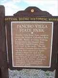 view gallery view galleryNE116.5 km | Pancho Villa State Park Historical Marker in New Mexico Historical Markers A New Mexico Historical Marker located at Pancho Villa State Park. posted by: KJKlock location: New Mexico date approved: 10/07/2009 last visited: 11/03/2010 |
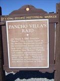 view gallery view galleryNE116.5 km | Pancho Villa’s Raid in New Mexico Historical Markers This New Mexico OSHM is on the back side of "Pancho Villa State Park" OSHM. posted by: leadhiker location: New Mexico date approved: 06/17/2011 last visited: never |
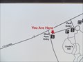 view gallery view galleryNE116.7 km |  U R Here Pancho Villa State Park - Columbus, NM U R Here Pancho Villa State Park - Columbus, NM
in 'You Are Here' Maps U R Here map at the west entrance to Pancho Villa State Park in Columbus. posted by: linkys location: New Mexico date approved: 05/31/2013 last visited: never |
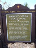 view gallery view galleryNE116.7 km | Pancho Villa State Park in New Mexico Historical Markers This is a second New Mexico OSHM for "Pancho Villa State Park". A different marker also named "Pancho Villa State Park" is about 600 feet away. posted by: leadhiker location: New Mexico date approved: 06/17/2011 last visited: 10/20/2012 |
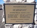 view gallery view galleryNE116.8 km |  In Memory of Thirteenth Cavalry - Columbus, NM In Memory of Thirteenth Cavalry - Columbus, NM
in Specific Veteran Memorials Soldiers Killed during the Pancho Villa Raid March 9, 1916
Pvt. Thomas F. Butler - Sgt. John G. Nievergelt
Sgt. Mark A. Dobbs - Cpl. Paul Simon
Pvt. Fred A. Griffin - Pvt. Jessie P. Taylor
Pvt. Frank T. Kindval - Cpl. Harry E. Wiswell posted by: leadhiker location: New Mexico date approved: 06/17/2011 last visited: never |
 view gallery view galleryNE116.8 km | COLUMBUS - NEW MEXICO in New Mexico Historical Markers COLUMBUS New Mexico,Pancho Villa State Park,Historical Museum posted by: GEO*Trailblazer 1 location: New Mexico date approved: 01/07/2007 last visited: 11/03/2010 |
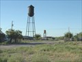 view gallery view galleryNE117 km | COLUMBUS - Water Tank in Water Towers COLUMBUS,NEW MEXICO WATER TANK posted by: GEO*Trailblazer 1 location: New Mexico date approved: 01/07/2007 last visited: 10/06/2009 |
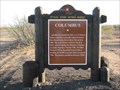 view gallery view galleryNE119.6 km | Columbus in New Mexico Historical Markers Historical marker on the north side of border town made famous by Pancho Villa's raid. posted by: linkys location: New Mexico date approved: 12/17/2009 last visited: 11/03/2010 |
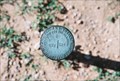 view gallery view galleryN125 km |  1914 Section Mark 1914 Section Mark
in U.S. Benchmarks 1914 Section mark for Sections 23 and 24 posted by: GmannL1 location: New Mexico date approved: 08/22/2008 last visited: never |
|