 view gallery view gallery S0.8 km S0.8 km
|   General De Gaulle Dr. (Louisiana Highway 428) New Orleans, LA General De Gaulle Dr. (Louisiana Highway 428) New Orleans, LA
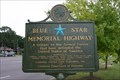
in Blue Star Memorial Highway Markers Blue Star Memorial Highway Marker on Louisiana Highway 428 (General De Gaulle Dr.) posted by:  Divecontom Divecontom location: Louisiana date approved: 02/24/2015 last visited: never |
 view gallery view gallery N1.1 km N1.1 km
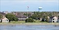
|  Old Naval Base Water Tower - New Orleans, LA Old Naval Base Water Tower - New Orleans, LA
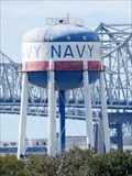
in Water Towers This water tower stands on the grounds of the former New Orleans Naval Support Activity (NSA) West Bank property in the Algiers historic district of New Orleans. posted by: denben location: Louisiana date approved: 07/25/2020 last visited: never |
 view gallery view galleryN1.1 km |  Old Naval Base Water Tower - New Orleans, LA Old Naval Base Water Tower - New Orleans, LA
in Satellite Imagery Oddities This water tower stands on the grounds of the former New Orleans Naval Support Activity (NSA) West Bank property in the Algiers historic district of New Orleans. posted by: denben location: Louisiana date approved: 07/20/2020 last visited: never |
 view gallery view gallery W1.9 km W1.9 km
|  Crescent City Connection - New Orleans, LA Crescent City Connection - New Orleans, LA
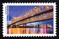
in Philatelic Photographs The twin spans of New Orleans’ Crescent City Connection appear on this 2022 U.S. postage stamp celebrating the ‘Mighty Mississippi.’ posted by:  hykesj hykesj location: Louisiana date approved: 01/15/2023 last visited: 06/18/2023 |
 view gallery view gallery SW1.9 km SW1.9 km
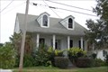
|  Kerner House - Gretna, LA Kerner House - Gretna, LA
in U.S. National Register of Historic Places Private home, located on Monroe St. in Gretna, a Westbank "suburb" of New Orleans. posted by: scrambler390 location: Louisiana date approved: 01/01/2010 last visited: never |
 view gallery view gallerySW2.1 km |  McDonoghville McDonoghville
in Louisiana Historical Markers Founded in 1815 by education philanthropist John McDonogh. Also known as Freetown where his freed slaves settled and Gouldsboro for railroad magnate Jay Gould. Incorporated 1913 into the City of Gretna. posted by: no_angel location: Louisiana date approved: 03/25/2009 last visited: 02/21/2015 |
 view gallery view gallery NE2.3 km NE2.3 km
|  "Steamboat Houses" - New Orleans "Steamboat Houses" - New Orleans
in Odd-Shaped Buildings These architectural stand-outs in the Holy Cross neighborhood of New Orleans were built in 1905 and 1912, and survived the storm and floods of hurricane Katrina. posted by: HaricotVert_52 location: Louisiana date approved: 04/19/2011 last visited: never |
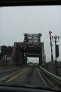
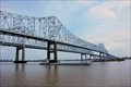 view gallery view galleryW2.4 km |  New Orleans - Mississippi River - Crescent City Connection Bridges New Orleans - Mississippi River - Crescent City Connection Bridges
in Truss Bridges New Orleans Louisiana Crescent City Connection Bridges, Mississippi River, River Mile 95.3 posted by: misfitt location: Louisiana date approved: 04/24/2007 last visited: 06/18/2023 |
 view gallery view galleryNE2.6 km |  Jackson Barracks - New Orleans, LA Jackson Barracks - New Orleans, LA
in Wikipedia Entries Jackson Barracks is a military base located in the Lower 9th Ward of New Orleans at the boundary of St. Bernard Parish, Louisiana. posted by: denben location: Louisiana date approved: 07/23/2020 last visited: never |
 view gallery view galleryNE2.6 km | Jackson Barracks - New Orleans, LA in U.S. National Register of Historic Places Jackson Barracks is a military base located in the Lower 9th Ward of New Orleans at the boundary of St. Bernard Parish, Louisiana. posted by: denben location: Louisiana date approved: 07/23/2020 last visited: never |
 view gallery view galleryN2.6 km |  The Joint - in the Bywater, New Orleans LA The Joint - in the Bywater, New Orleans LA
in Classic BBQ and Sandwich Joints We were hungry but new to the area, and just decided to mosey in here for a bite. Little did we know what we had stumbled upon. posted by: HaricotVert_52 location: Louisiana date approved: 03/28/2011 last visited: 02/12/2018 |
 view gallery view galleryW2.7 km |  Mother River Statue - New Orleans, Louisiana. Mother River Statue - New Orleans, Louisiana.
in Figurative Public Sculpture This magnificent statue is located on the Mississippi river front in downtown New Orleans, Louisiana on “Port of New Orleans Pl.” almost under the Crescent City twin bridges. posted by: misfitt location: Louisiana date approved: 09/10/2008 last visited: never |
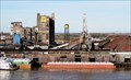
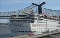 view gallery view galleryW2.7 km |  Port of New Orleans, LA Port of New Orleans, LA
in Cruise Ship Ports This busy port is on the busy Mississippi River. posted by: way2whacky location: Louisiana date approved: 12/16/2008 last visited: 12/28/2014 |
 view gallery view galleryN2.7 km |  Poland Avenue Market - New Orleans LA Poland Avenue Market - New Orleans LA
in Ghost Signs There is so much restoration work going on in New Orleans, but "ghosts" of the old buildings can still be found offering some of the history of the neighborhoods. posted by: HaricotVert_52 location: Louisiana date approved: 03/30/2011 last visited: never |
 view gallery view gallery NW2.7 km NW2.7 km
|  Algiers Ferry Terminal - New Orleans, LA Algiers Ferry Terminal - New Orleans, LA
in NRHP Historic Districts - Contributing Buildings The ferry has been in operation since 1827. The terminal makes a good point for exploring historic Algiers Point. posted by: JimmyEv location: Louisiana date approved: 05/30/2008 last visited: 12/26/2011 |
 view gallery view galleryW2.7 km | Crescent City Connection - New Orleans, LA in Satellite Imagery Oddities The Crescent City Connection (CCC), formerly the Greater New Orleans Bridge, refers to twin cantilever bridges that carry U.S. Highway 90 Business over the Mississippi River in New Orleans, Louisiana, United States. posted by: denben location: Louisiana date approved: 04/19/2020 last visited: 06/18/2023 |
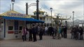
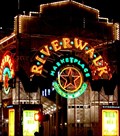 view gallery view galleryW2.9 km |  Riverwalk Marketplace - New Orleans, LA Riverwalk Marketplace - New Orleans, LA
in Indoor Malls If you want to experience the mighty Mississippi, and learn something about it, this is the place to come. An outdoor promenade is built along the riverside of the mall. Not only are the river views excellent, twenty-three interpretive plaques describe the history of, and interesting facts about, the Mississippi. posted by: JimmyEv location: Louisiana date approved: 04/08/2007 last visited: 12/26/2015 |
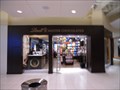 view gallery view galleryW2.9 km |  Lindt Chocolate - New Orleans, LA Lindt Chocolate - New Orleans, LA
in Candy Stores Located in the Riverside Marketplace Mall. posted by: Metro2 location: Louisiana date approved: 10/24/2015 last visited: 08/30/2014 |
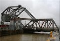 view gallery view galleryN2.9 km |  St. Claude Avenue Bridge -- New Orleans LA St. Claude Avenue Bridge -- New Orleans LA
in Moving Bridges The St. Claude Avenue bridge is a steel truss bascule bridge that carries Louisiana State Highway 46 over the Industrial Harbor Navigation Canal posted by: Benchmark Blasterz location: Louisiana date approved: 02/12/2015 last visited: 12/28/2014 |
 view gallery view galleryN2.9 km | St. Claude Avenue Bridge -- New Orleans LA in Truss Bridges The St. Claude Avenue bridge is a steel truss bascule bridge over the Industrial Harbor Navigation Canal posted by: Benchmark Blasterz location: Louisiana date approved: 02/12/2015 last visited: 12/28/2014 |
 view gallery view gallery E3.1 km E3.1 km
|  The Domino Sugar Refinery 100 Year Anniversary - Chalmette, LA The Domino Sugar Refinery 100 Year Anniversary - Chalmette, LA
in News Article Locations The Domino Sugar Chalmette Refinery which turned 100 in 2009 is located along the Mississippi River, in Chalmette, 9 miles east of New Orleans, Louisiana. posted by: denben location: Louisiana date approved: 07/19/2020 last visited: never |
 view gallery view galleryE3.1 km |  LARGEST - Sugar Refinery in North America - Chalmette, LA LARGEST - Sugar Refinery in North America - Chalmette, LA
in Superlatives The Domino Sugar Chalmette Refinery is located along the Mississippi River, in Chalmette, 9 miles east of New Orleans, Louisiana. posted by: denben location: Louisiana date approved: 07/20/2020 last visited: never |
 view gallery view galleryNW3.1 km |  Creole Queen - New Orleans, LA Creole Queen - New Orleans, LA
in Scenic Boat Rides A paddle wheeler on the Mississippi leaving daily from New Orleans posted by: DnRseekers location: Louisiana date approved: 01/21/2014 last visited: 12/26/2011 |
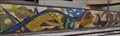
 view gallery view galleryW3.1 km |  Twin City Mural - New Orleans, LA Twin City Mural - New Orleans, LA
in Mosaics This mural is located at the Riverfront Streetcar 7 Poydras St Station next to the Hilton Hotel. posted by: Metro2 location: Louisiana date approved: 12/12/2015 last visited: 09/03/2015 |
 view gallery view galleryW3.1 km |  Twin City Mural - New Orleans, LA Twin City Mural - New Orleans, LA
in Murals This mural is located at the Riverfront Streetcar 7 Poydras St Station next to the Hilton Hotel. posted by: Metro2 location: Louisiana date approved: 12/12/2015 last visited: 09/03/2015 |
|