 view gallery view gallery E4.2 km E4.2 km
|   Fajardo PR Tribunal Fajardo PR Tribunal
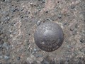
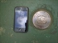
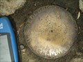
in U.S. Benchmarks This is a mark that you can find in Puerto Rico. posted by:  Alegre Alegre location: Puerto Rico date approved: 04/02/2010 last visited: never |
 view gallery view galleryE5.3 km |  Fajardo inn Fajardo inn
in Recommended Accommodation The Fajardo Inn has the perfect facilities to accommodate small and large gatherings like a Puerto Rico wedding. posted by: catherineannc location: Puerto Rico date approved: 01/02/2011 last visited: never |
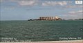 view gallery view galleryE6.9 km |  Sunbay Marina - Fajardo, Puerto Rico Sunbay Marina - Fajardo, Puerto Rico
in Web Cameras This webcam is Located on the eastern coast of Puerto Rico in Fajardo and offers 3 views of the area. posted by: Lightnin Bug location: Puerto Rico date approved: 01/21/2024 last visited: never |
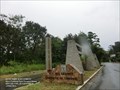
 view gallery view gallery W8 km W8 km
|  El Yunque National Forest - Rio Grande PR El Yunque National Forest - Rio Grande PR
in National Parks of the World El Yunque National Forest is located in northeastern Puerto Rico. It is the only tropical rainforest in the United States National Forest System. It is located on the slopes of the Sierra de Luquillo mountains encompassing more than 28,000 acres. posted by: Don.Morfe location: Puerto Rico date approved: 07/18/2023 last visited: 07/18/2023 |
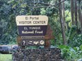 view gallery view galleryW8 km |  Visitor Center-El Yunque National Forest - Rio Grande PR Visitor Center-El Yunque National Forest - Rio Grande PR
in Tourist Information Centers - Visitor Centers El Portal Visitor Center-Located at the main park entrance on PR-191, the beautiful El Portal Visitor Center is a great place to begin your journey into El Yunque. There is an accessible interpretive trail that circles the property. posted by: Don.Morfe location: Puerto Rico date approved: 07/16/2023 last visited: 07/16/2023 |
 view gallery view galleryW8 km |  El Yunque National Forest - Rio Grande PR El Yunque National Forest - Rio Grande PR
in Official Local Tourism Attractions El Yunque National Forest is located in northeastern Puerto Rico. It is the only tropical rainforest in the United States National Forest System. It is located on the slopes of the Sierra de Luquillo mountains encompassing more than 28,000 acres. posted by: Don.Morfe location: Puerto Rico date approved: 07/15/2023 last visited: 07/16/2023 |
 view gallery view galleryW8 km |  ONLY - Tropical rainforest in the U. S. National Forest System - El Yunque National Forest - Rio Grande PR ONLY - Tropical rainforest in the U. S. National Forest System - El Yunque National Forest - Rio Grande PR
in Superlatives El Yunque National Forest is located in northeastern Puerto Rico. It is the only tropical rainforest in the United States National Forest System. It is located on the slopes of the Sierra de Luquillo mountains encompassing more than 28,000 acres. posted by: Don.Morfe location: Puerto Rico date approved: 07/15/2023 last visited: 07/16/2023 |
 view gallery view galleryW8 km |  El Yunque National Forest - Rio Grande PR El Yunque National Forest - Rio Grande PR
in Wikipedia Entries El Yunque National Forest is located in northeastern Puerto Rico. It is the only tropical rainforest in the United States National Forest System. It is located on the slopes of the Sierra de Luquillo mountains encompassing more than 28,000 acres. posted by: Don.Morfe location: Puerto Rico date approved: 07/15/2023 last visited: 07/15/2023 |
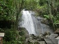 view gallery view galleryW8 km |  La Coca Falls-El Yunque National Forest - Rio Grande PR La Coca Falls-El Yunque National Forest - Rio Grande PR
in Waterfalls The La Coca Falls is in the El Yunque National Forest on Highway PR191, Rio Grande PR 00745. posted by: Don.Morfe location: Puerto Rico date approved: 07/16/2023 last visited: 07/16/2023 |
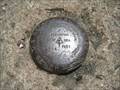
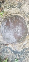 view gallery view galleryW8.9 km | EYNF 23 (DR5118) El Yunque National Forest, PR in U.S. Benchmarks USDA Forestry Service Control Network posted by:  HiddenCrazy HiddenCrazy location: Puerto Rico date approved: 01/17/2023 last visited: never |
  NW9 km NW9 km
|  Hacienda Carabali - Mountain Biking Hacienda Carabali - Mountain Biking
in Mountain Bike Trailheads Hacienda Carabali, 600-Acre Adventure Ranch in Luquillo, Puerto Rico posted by:  TheAdventurers TheAdventurers location: Puerto Rico date approved: 02/15/2007 last visited: never |
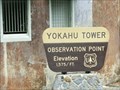 view gallery view galleryW9.2 km |  Yokahu Tower - Rio Grande, Puerto Rico-Elevation 1575'' Yokahu Tower - Rio Grande, Puerto Rico-Elevation 1575''
in Elevation Signs Yokahú Tower is an observation tower within El Yunque National Forest on the island of Puerto Rico. The Yokahú Tower is one of the two observation towers located in the park and is at an elevation of 1,575 feet. posted by: Don.Morfe location: Puerto Rico date approved: 08/09/2020 last visited: 02/18/2023 |
 view gallery view gallery NE9.5 km NE9.5 km
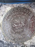
| 31643-RM-2 - Las Cabezas de San Juan in U.S. Benchmarks Survey Marker stamped DEFENSE MAPPING AGENCY with the designation '31643-RM-2'. posted by: Mocrin location: Puerto Rico date approved: 01/31/2016 last visited: 01/30/2016 |
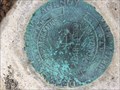
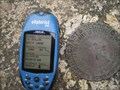
 view gallery view galleryW10.5 km | Yokahu Observation Tower in U.S. Benchmarks GPS Test Network Disk
US Forest Service
Department of Agriculture posted by: el_norso location: Puerto Rico date approved: 07/29/2012 last visited: 01/16/2023 |
 view gallery view galleryW11.3 km | Yunque 2 in U.S. Benchmarks Top of stone tower at top of El Yunque mountain. posted by: NomadRip location: Puerto Rico date approved: 01/17/2009 last visited: 12/28/2016 |
 view gallery view galleryW11.3 km | Yunque 2 USGS No 4 '1934' in U.S. Benchmarks One of three Benchmarks at the top of the Tower at El Yunque Peak. posted by: HanSohn location: Puerto Rico date approved: 02/26/2009 last visited: 12/28/2016 |
 view gallery view galleryW11.3 km | Yunque 2 USGS No 5 '1934' in U.S. Benchmarks One of three marks found on the Tower at the Top at El Yunque Peak. posted by: HanSohn location: Puerto Rico date approved: 02/26/2009 last visited: 12/28/2016 |
 view gallery view galleryW11.7 km | MT BRITTON TOWER in El Yunque in U.S. Benchmarks Benchmark on top of Mount Britton Tower. 1947 posted by: HanSohn location: Puerto Rico date approved: 02/26/2009 last visited: 11/19/2019 |
 view gallery view gallery S22.5 km S22.5 km
| El Morrillo Bunkers in U.S. Benchmarks Concrete square block with a triangle, in the center, a square nail with a cross. The block sets atop El Morrillo mount in Humacao Natural Reserve. posted by: el_norso location: Puerto Rico date approved: 08/23/2012 last visited: never |
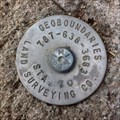 view gallery view gallery SW30.6 km SW30.6 km
| Survey Marker STA 70 - Humacao, Puerto Rico in U.S. Benchmarks Used to measure and mark boundaries on the surface of the earth. Among my qualities are to indicate the boundaries of the property, building designs and Mapping science. posted by: TITERAPR location: Puerto Rico date approved: 03/31/2014 last visited: never |
 view gallery view galleryW35.4 km |  Domino's - SJU - Carolina - Puerto Rico Domino's - SJU - Carolina - Puerto Rico
in Domino's Pizza This waymark is located in Luis Muñoz Marín International Airport. posted by: elyob location: Puerto Rico date approved: 03/20/2013 last visited: 12/25/2016 |
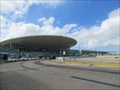
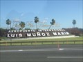
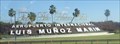 view gallery view galleryW35.6 km |  Luis Munoz Marin International Airport - Carolina, Puerto Rico Luis Munoz Marin International Airport - Carolina, Puerto Rico
in People-Named Places Luis Munoz Marin International Airport is a joint civil-military international airport named for Puerto Rico's first democratically elected governor and located in suburban Carolina, Puerto Rico, three miles (five km) southeast of San Juan. posted by: denben location: Puerto Rico date approved: 12/20/2018 last visited: 01/17/2019 |
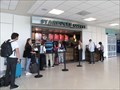 view gallery view galleryW35.6 km |  Starbucks - Luis Muñoz Marín International Airport - Carolina, Puerto Rico Starbucks - Luis Muñoz Marín International Airport - Carolina, Puerto Rico
in Starbucks Stores This Starbucks is located inside Terminal C at the Luis Muñoz Marín International Airport in Carolina, Puerto Rico. posted by: denben location: Puerto Rico date approved: 12/18/2018 last visited: never |
 view gallery view galleryW35.6 km | Luis Munoz Marin International Airport - Carolina, Puerto Rico in Wikipedia Entries Luis Munoz Marin International Airport is a joint civil-military international airport named for Puerto Rico's first democratically elected governor and located in suburban Carolina, Puerto Rico, three miles (five km) southeast of San Juan. posted by: denben location: Puerto Rico date approved: 12/18/2018 last visited: 01/17/2019 |
 view gallery view galleryW35.6 km |  Luis Munoz Marin International Airport - Carolina, Puerto Rico Luis Munoz Marin International Airport - Carolina, Puerto Rico
in Airports Luis Munoz Marin International Airport is a joint civil-military international airport named for Puerto Rico's first democratically elected governor and located in suburban Carolina, Puerto Rico, three miles (five km) southeast of San Juan. posted by: denben location: Puerto Rico date approved: 12/19/2018 last visited: 01/17/2019 |
|