Voie Domitienne - Grabels, France
Posted by: Groundspeak Premium Member YvesProvence
N 43° 38.659 E 003° 49.383
31T E 566380 N 4832698
La voie Domitienne à Grabels
Waymark Code: WMXTBR
Location: Occitanie, France
Date Posted: 02/24/2018
Published By:Groundspeak Premium Member bluesnote
Views: 6

FR La voie Domitienne (Via Domitia) est une voie romaine construite à partir de 118 av. J.-C. pour relier l’Italie à la péninsule Ibérique en traversant la Gaule narbonnaise.
Cette route devait assurer les communications avec Rome et permettre l’installation et la circulation de garnisons protégeant des villes devenues romaines. La colonie romaine de Narbo Martius (Narbonne) est fondée sur son parcours, et devient la plus importante ville du sud de la Gaule.
Première route construite par les Romains en Gaule, elle franchit les Alpes au col de Montgenèvre (1 850 m), suit la vallée de la Durance, longe le Luberon par le nord, franchit le Rhône à Beaucaire, passe par Nîmes (Nemausus) et suit la côte du golfe du Lion jusqu'à l'Espagne, en reliant sur son chemin les principales villes romaines (Ugernum/Beaucaire, Nemausus/Nîmes, Baeterrae/Béziers, Narbo/Narbonne, Ruscino), correspondant à une ancienne cité gauloise ou fondées à proximité. Elle contourne donc le territoire de Massalia, cité grecque indépendante jusqu'en -48 (devenue Massilia en latin).
Bien que destinée à la circulation des légions romaines, elle est rapidement empruntée par les marchands. Plus tard, ce sont les fonctionnaires de la République puis de l’Empire qui l’utilisèrent (poste impériale ou cursus publicus). La construction de cette voie fut bénéfique à l'économie locale grâce aux échanges qu'elle facilita entre les cités.
Le tracé de la Via Domitia est connu assez précisément grâce à plusieurs sources : les gobelets de Vicarello, la Table de Peutinger et l'Itinéraire d'Antonin (la source la moins fiable). Elle est construite de manière presque rectiligne sur des terrains solides. L'observation des cartes topographiques montre très souvent le parcours qu'elle empruntait. Les routes modernes empruntent encore souvent le tracé de la Via Domitia (N85 - N100 - A9…).

Ici, à Grabels, une courte partie de cette voie romaine est préservée car un rond-point a été construit et la route contourne les vestiges romains.


Via domitia map600x600 (1)
EN The Domitian Way is a Roman road built from 118 BC. J.-C. to connect Italy to the Iberian Peninsula while crossing the Gaul narbonnaise. This road makes it possible to assure the communications with Rome and to allow the installation and the circulation of the garrisons protects from the cities become Roman. The Roman colony of Narbo Martius (Narbonne) is based on its route, and becomes the most important city of southern Gaul. The first road built by the Romans in Gaul, it crosses the Alps at the Montgenèvre pass (1,850 m), the Durance valley, the Lubéron by the north, the Rhone franchise at Beaucaire, passes through Nîmes (Nemausus ) and corresponding to the coast of the Gulf of Lion to Spain, based on the main Roman cities (Ugernum / Beaucaire, Nemausus / Nimes, Baeterrae / Beziers, Narbo / Narbonne, Ruscino), corresponding to an ancient Gallic city or founded nearby3. It bypasses the territory of Massalia, an independent Greek city until 48 (now Massilia in Latin).
Although intended for the circulation of the Roman legions, it is quickly borrowed by the merchants. Later, it is the civil servants of the Republic then of the Empire who uses it (imperial post or curriculum publicus). The construction of this way was beneficial to the local economy thanks to the exchanges it facilitated between the cities. The path of Via Domitia is known enough thanks to several sources: the goblets of Vicarello, the Table of Peutinger and the Itinerary of Antonin. It is built almost rectilinear on solid ground. The observation of topographic maps very often shows the route that it took. Modern roads often still follow the route of Via Domitia (N85 - N100 - A9 ...).

Here in Grabels, a short part of this Roman road is preserved as a roundabout has been built and the road bypasses the Roman remains.


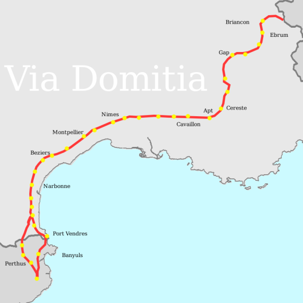
Source : https://fr.wikipedia.org/wiki/Voie_Domitienne

Bonus: La zone en photo à 360°
Most Relevant Historical Period: Roman Republic 509 B.C. - 27 B.C.

Admission Fee: 0

Condition: Some remaining traces (ruins) or pieces

Opening days/times: Not listed

Web Site: Not listed

Visit Instructions:
A complete sentence or two or an uploaded photo taken by the waymarker will be required in the log to confirm that the logger is participating in the hobby in good faith. Logs of only a few words like "Visited it" without an original photo are subject to deletion.
Search for...
Geocaching.com Google Map
Google Maps
MapQuest
Bing Maps
Nearest Waymarks
Nearest Ancient Roman Civilization
Nearest Geocaches
Create a scavenger hunt using this waymark as the center point
Recent Visits/Logs:
Date Logged Log User Rating  
Jean Bat' visited Voie Domitienne - Grabels, France 04/21/2018 Jean Bat' visited it