
Le Clocher de l'Église Notre-Dame-de-l'Assomption - Ailly-le-Haut-Clocher, France
Posted by:  pmaupin
N 50° 04.555 E 001° 59.682
31U E 428067 N 5547555
[EN] The Church Notre-Dame-de-l'Assomption is classified as a historical monument, it dates from the thirteenth century. [FR] L'Eglise Notre-Dame-de-l'Assomption est classée monument historique, elle date du XIIIe siècle.
Waymark Code: WMWJQ8
Location: Hauts-de-France, France
Date Posted: 09/13/2017
Views: 4

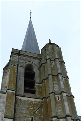
 The most remarkable part of the church is the bell-tower which stands up to 45 m. The base is made up of a quadrangular tower with an 8-sided turret on the staircase, surmounted by a small cupola on which stands a statue of Saint John the Baptist.
At 25 m from the ground a very sharp octagonal pyramid springs up. Each of the 8 sides measures 20 m high and 2.80 m base. Two bells remain in the interior.
This bell-tower served as a reference point during measurements for the realization of the Cassini map. (large map of the France in the 18th century)
Its steeple finished by a roof tapered arrow covered with slates,
During the last war, the bell-tower was an observatory for the German army, which installed an anti-aircraft machine-gun.
Sources : The Church
 La partie la plus remarquable de l'église est le clocher quise dresse jusqu'à 45 m. La base est formé d'une tour quadrangulaire à laquelle est accolée une tourelle à 8 pans, logis de l'escalier, surmonté d'une petite coupole sur laquelle trône une statue de Saint-Jean-Baptiste.
A 25 m du sol s'élance une pyramide octogonale très aigüe. Chacun des 8 pans mesure 20 m de haut sur 2.80 m de base. Deux cloches subsistent à l'ntérieur.
Ce clocher a servi comme point de repère lors de mesurages pour la réalisation de la carte de Cassini. (grande carte de la Fance au XVIII ème siècle)
Son clocher terminé par un toit en flèche effilée recouverte d'ardoises,
Pendant la dernière guerre, le clocher tint lieu d'observatoire pour l'armée allemande qui y installa une mitrailleuse anti-aérienne.
Sources : L’Eglise