[EN] If it has a tranquil appearance, it remains an active volcano as evidenced by the hot springs on its western flank.
Rest assured ! The last eruption dates back to 1932 and underground activity is monitored continuously by the Cadet Morne Observatory, home to one of the largest seismographs in the world.
This region entered history dramatically on the morning of May 8, 1902, when the eruption of Mount Pelee, one of the most deadly natural disasters of the 20th century, killed the city's 30,000 inhabitants. Saint-Pierre in just a few minutes.
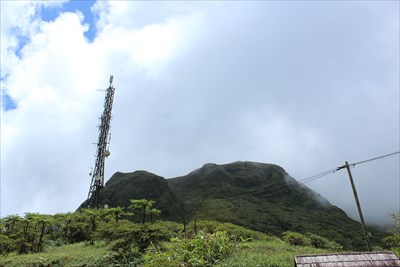
Several trails allow to explore the cones resulting from the eruptions of 1902 and 1932. Hikers can launch themselves to the assault of the summit from the face that overlooks the Caribbean Sea.
This journey opens with stunning views over the city of Saint-Pierre and the coast. The North Slope offers a variety of landscapes of banana plantations, rainforest and extensive windswept areas.
The route most often traveled by the hikers, the fin and the plateau des Palmistes, starts from the car park located on the eastern flank of the mountain.
[FR] Si elle présente une apparence tranquille, elle reste un volcan en activité comme le prouvent les sources d’eau chaude situées sur son flanc occidental.
Rassurez-vous ! La dernière éruption date de 1932 et l’activité souterraine est surveillée en permanence par l’Observatoire du Morne des Cadets qui abrite l’un des plus gros sismographes au monde.
Cette région est entrée dans l’Histoire de façon dramatique le matin du 8 mai 1902 lorsque l’éruption de la montagne Pelée, l’une des catastrophes naturelles les plus meurtrières du 20 ème siècle, a tué les 30 000 habitants de la ville de Saint-Pierre en quelques minutes seulement.
Plusieurs sentiers permettent d’explorer les cônes issus des éruptions de 1902 et 1932. Les randonneurs peuvent se lancer à l’assaut du sommet depuis la face qui surplombe la mer des Caraïbes.
Ce trajet s’ouvre sur de superbes vues sur la ville de Saint-Pierre et sur la côte. Le versant Nord offre des paysages très variés de bananeraies, de forêt tropicale et de vastes espaces balayés par le vent.
Le parcours le plus souvent parcouru par les randonneurs, par l’aileron et le plateau des Palmistes, part du parking situé sur le flanc oriental de la montagne.
Sources : La Montagne Pelée