
Whitney Glacier - Siskiyou County, CA
N 41° 37.020 W 122° 12.090
10T E 566525 N 4607561
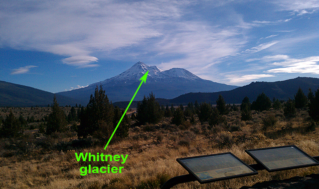
An interpretive plaque at the Mt. Shasta Vista Point stopover mentions Whitney glacier as the largest in California and one of five that exist on Mt. Shasta. Visitors can see Whitney glacier on a clear day.
Waymark Code: WMPH7P
Location: California, United States
Date Posted: 08/31/2015
Views: 11
Visitors to the Mt. Shasta Vista Point stopover are treated to a spectacular view of Mt. Shasta as well as some interpretive signs by the Volcanic Legacy National Scenic Byway organization that give a great history lesson regarding this area. There is also a bronze plaque imbedded in a lava rock wall that says the following:
Dominating the landscape, Mt. Shasta can be seen for 100 miles from certain points drawing hikers, skiers and travelers. Mt. shasta rises 11,000' from the base to summit for a total elevation of 14,162' above sea level, one of the nation's largest rises, ranking 49th. It is one of the southermost volcanoes in the Cascade Range and is the second tallest, falling short of Mt. Ranier by 248'. It has a 17 mile diameter with 5 glaciers, the Whitney glacier being the largest in California. The most recent eruption occurred in 1786 and was witnessed from the sea by explorer La Perouse.
I did some online research on the Whitney glacier and discovered that this plaque's verbiage is not entirely accurate. There are actually SEVEN glaciers that exist on Mt. Shasta and recognized by the USGS: Whitney Glacier, Bolam Glacier, Hotlum Glacier, Wintun Glacier, Watkins Glacier, Konwakiton Glacier, and Mud Creek Glacier. And there are possibly TEN glaciers total, as suggested by two respected geologists, Phillip Rhodes and Frances Biles (click here for online reference).
In any case, if visitors are fortunate enough to take a quick break and check out this vista point on a clear day, they won't be disappointed with the almost-surreal nature that this wonderful mountain bestows. The Native Americans called it 'medicine'.
To access the mountain itself and see the glaciers up close, you'll need to drive up the mountain about 12 miles to a the Bunny Flat Trailhead. You can get hiking information from the Trinity-Shasta National Forest website.