
National Parks - Canada - Fathom Five National Marine Park
N 45° 17.926 W 081° 37.038
17T E 451600 N 5016325
The FIRST National Marine Park created in Canada!
Waymark Code: WMNDF
Location: Ontario, Canada
Date Posted: 08/26/2006
Views: 158

Park Sign
Fathom Five, Canada’s first national marine park, consists of 20 islands to the north and east of the Bruce Peninsula, 130 square kilometres of surface water, the ecosystem reaching 200 metres below, and the park’s tiny landbase at Tobermory Harbour. Composed of green islands, lake bottoms and clear cold water, it is representative of the Georgian Bay Marine region. The islands of Fathom Five, created where the Niagara escarpment dips underwater off the peninsula, comprise the northernmost park in a system of over 100 escarpment parks and protected areas linked by the Bruce Trail. Established in 1987, along with the Bruce Peninsula National Park, it protects the on- and off-shore landscape renowned for its scenic beauty, dramatic escarpment topography, and remarkable collection of 21 historic shipwrecks, some just a few metres from shore and all within the park’s crystal clear waters. The human history evoked by the spectacle of shipwrecks that make for some of the best diving in North America is no more fascinating than the breathtaking story told by this underwater topography. - Source: Great Canadian Parks
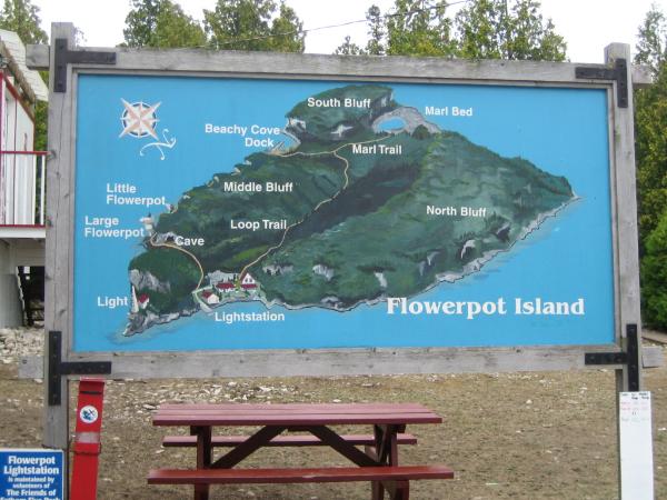
Map of Flowerpot Island
Now for my part. Fathom Five is a gorgeous location that is reknown for two large 'flowerpots' that have formed from a complicated process. It also has a significant history due to local fishing and shipping interests. Check out both Flowerpots, the Lighthouse Keeper's house and the Cave. You can spend two hours here easily and camping can be arranged as well at one of six sites. Camp fires are NOT permitted. Offtrail activity is NOT permitted - Please respect the park!

Larger Flowerpot

Smaller Flowerpot (still very big)
Hope you enjoy the Waymark Visit!
 The Blue Quasar
Visit Instructions:A log will require a recent photograph at the coordinates. Some of these locations will be placed for the scenery, so a gpsr will just ruin the picture.
If you don't have a digital camera post a descriptive log.