
OHP - "SALTER'S MERIDIAN 1856"
Posted by:  bwmick
N 46° 24.252 W 081° 10.926
17T E 486002 N 5138974
A roadside stop just west of Sudbury on HWY 55.
Waymark Code: WMKZT
Location: Ontario, Canada
Date Posted: 08/13/2006
Views: 40
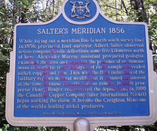
While laying out a meridian line (a north-south survey line) in 1856, provincial land surveyor Albert Salter observed severe compass needle deflections some five kilometeres north of here. Alexander Murray, assistant provincial geologist, examined the area and reported 'the presence of an immense mass of magnetic trap'. Analysis of rock samples revealed nickel, copper and iron. This was the first indications of the Sudbury region's mineral wealth, but it aroused no interest at the time because the site was so remote. In 1886 prospector Henry Ranger rediscovered the deposit and in 1900 the Canadain Copper Company (later International Nickel) began working the claim. It became the Creighton Mine, one of the world's leading nickel producers.
Address or location of plaque: Near Naughton on HWY 55

Physical location of plaque: Park
"Ontario Plaques" Website for this "Plaque": [Web Link]
Description of any physical remains at site of "Historical Plaque": plaque itself
This 'Plaque' describes: An 'Event'
Condition of sign: some spraypaint on english side
Is this a bilingual sign?: No !
A web-site for more details.: Not listed
What is the second/third language?: Not listed
|
Visit Instructions:
A "Visited" only remark, will be deleted.
No Waymark owner "Visits" allowed when setting up the Waymark.
Subsequent visits, at another time with photo are acceptable.
NOTE: All photos must include the 'O.H.P.Plaque' at its location to qualify for a "Visited"