
Battle of New Bern, Marker CC-1
Posted by:  showbizkid
N 35° 06.484 W 077° 02.124
18S E 314497 N 3886922
This interpretive marker describes the Battle of New Bern fought in March 1862. This early Union victory denied the Confederates use of the lower Neuse River and gave the Federals a base of operations in the region from which to launch further attacks. Battlefield maps and considerable text describe the participants, actions and troop movements during the battle.
Waymark Code: WMK44
Location: North Carolina, United States
Date Posted: 08/04/2006
Views: 36
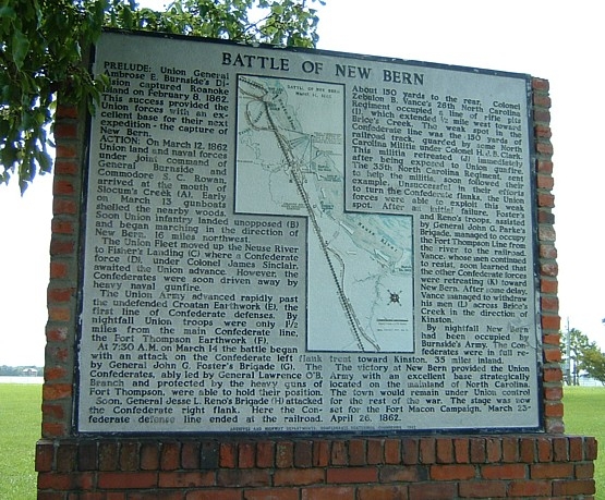
On March 11, 1862 Brig. Gen. Ambrose E. Burnside’s command embarked from Roanoke Island to rendezvous with Union gunboats at Hatteras Inlet for an expedition against New Bern.
On March 13, the fleet sailed up the Neuse River and disembarked infantry on the river’s south bank to approach the New Bern defenses. The Confederate defense was commanded by Brig. Gen. Lawrence Branch.
On March 14, John G. Foster’s, Jesse Reno’s, and John G. Parke’s brigades attacked along the railroad and after four hours of fighting drove the Confederates out of their fortifications. The Federals captured nine forts and 41 heavy guns and occupied a base which they would hold to the end of the war, in spite of several Confederate attempts to recover the town.
To record your own visit to this waymark, take and post your own photo of the waymark with your log. Logs must contain an original photo as proof of your visit, please.
Visit Instructions:Photos of your visit to the marker are required, but PLEASE, no old vacation photos taken just because it was there!
Comments about your visit, interesting nearby areas and any significant information you may have on this waymark are encouraged.
Most of all, enjoy the History that North Carolina has to offer! From the Mountains to the Ocean .. it's all here!