
Martins Hut
Posted by:  StagsRoar
S 46° 15.782 E 167° 51.614
58G E 720418 N 4872750
Located in the South-Eastern side of the Longwood Ranges in Southland, New Zealand.
Grid reference: Topo50 map sheet CG08, E1203899, N4864030
Waymark Code: WMH5X
Location: South Island, New Zealand
Date Posted: 07/12/2006
Views: 67
It needs to be stated that the coordinates listed for Martins Hut are as accurate as I can establish until I can get back there or someone else can establish better accuracy with a
GPS than I have listed. I'm sure the coordinates are not to far off if they are off at all but use them only as a guide. In any case once you are on the track to this hut there is no missing the hut really once you near it.
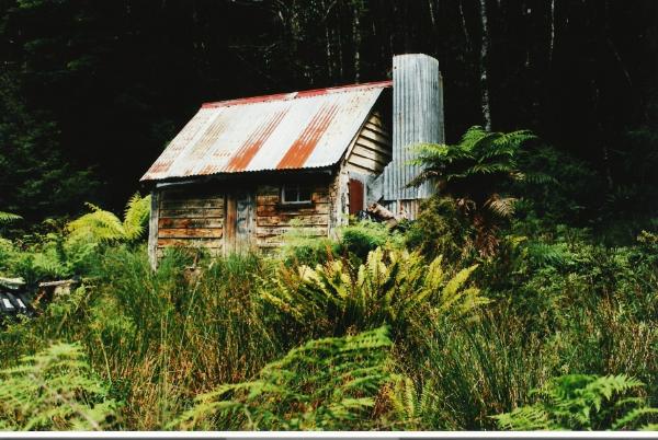
Martins Hut is sited in the Longwood Ranges and was established many years ago and I believe is now listed as a Historical Place by the
Department of Conservation. I am unable to determine when exactly it was built but it would seem it was built as a maintenance hut for the nearby watercourse that run south for the Gold Mining operations in the earlier part of this century that took place at the Southern end of the Longwood Ranges in the Round Hill Hill area. Some restoration work has been done to this hut but evidence of idiots and vandals still scar this historical little hut in the form of grafitti. To access this hut you must firstly venture up the Pourakino Valley Road to it's junction with Kiwi Rd/Cascade Rd at coordinates S46*14.725 E167*56.075. I cannot remember the road sign at this junction - whether it says Kiwi Road or Cascade Road as maps have it listed as Cascade Road, yet when you drive along it and cross the stock grid entering the Longwoods true there is a sign calling it Kiwi Road. Maybe Kiwi Road begins at the stock grid. Keep travelling this dirt (vaguely maintained) road until you get to the junction at S46*15.867 E167*52.589. The main part of this road bends around to the left and there is an old logging road/track that goes straight ahead. I would advise parking here at this junction if you have a regular car but if you do have 4WD you may be game enough to tackle it but it is pretty rough. Head up the old logging track straight ahead and keep an eye out on your left side until you see a painted (?red/?pink) waratah [Y post] marking the start of the track which should be at the approx coordinates of S46*15.811 E167*52.356.
The track itself is really nothing more than a reasonably worn route and is for the most part used by
Hunters
&
Deerstalkers
. Your time to Martins Hut from here is about 40 mins walk on a gentle upward gradient through regenerated Beech Forest.
Once you arrive and see this hut you realise it is not somewhere you would want to stay unless it was absolutely imperative. The hut is of dirt floor with a couple of bunks made of tree poles lain horizontally with Hessian sacking nailed across. I haven't tried the open fireplace but I would wager to say that I could imagine the hut representing a steam bath with that thing cranked up. The hut is dark with poor light and poor ventilation and really is just a hut you may want to see for interest sake as opposed for accommodation purposes. From the hut the track does carry on for another 20-30 mins to the open tops of Mount Longwood which has been my main reason in the past for coming through here. Its a fairly easy and enjoyable walk to the open tops with some good views to be had at the tops - looking East back over Southland and West over TeWaeWae Bay across Tautapere township and the Waiau River. Views of the beginnings of Southern
Fiordland
and the Princess Mountains can be seen up here also as well as view of
Stewart Island
and Mt Anglem to the south on a good day. If travelling this track GPS cover may be pretty scratchy in view of the bush canopy and cover therefore it is strongly advised that a
Topographical Map
and compass be carried. Topographical Map Reference # for this area is: D46 Riverton/Aparima. Other vehicles on the Kiwi Road would indicate possiblity of Hunters in the area as well.
 Hunters often in the area Hunters often in the area |
 Compass & Topographical Map Suggested / Required Compass & Topographical Map Suggested / Required |
 Approx 45 mins Hiking required Approx 45 mins Hiking required |
 Scenic View - Bring A Camera Scenic View - Bring A Camera |
 Fire Danger, No Campfires Fire Danger, No Campfires |