
William Patterson Farm - Gettysburg, PA
N 39° 48.372 W 077° 13.811
18S E 309086 N 4408627
The Park Service recently dumped a bunch of money into this farm house, bringing it back to its former Civil War glory. According to the sign of history our front, the house served as a field hospital during the Battle of Gettysburg.
Waymark Code: WMGYMD
Location: Pennsylvania, United States
Date Posted: 04/24/2013
Views: 4

There are a number of these large, blue metal signs placed around various structures which served as field hospitals. They were all placed in the early 80s by the Hospital and Healthsystem Association of PA & HG-AC. This sign of history reads:
.
CIVIL WAR HOSPITAL
_____________________
William Patterson Farm
July, 1863
_____________________
Erected by: The Hospital and Healthsystems Assoc. of PA & HG-AC 1983.
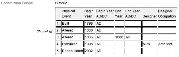
Not too long ago, this house was trashed, dilapidated and ready to fall over. Today, it is gorgeous and a fine representation of the type of structures that stood here during the Battle of Gettysburg. The house was first built in 1798 and it is the oldest log plank house existing on the battlefield. Curiously though, despite its notoriety, the various Gettysburg sites which document the farm houses all neglected to document this house. From the pictures I saw, it appears this house was completely rebuilt. I found several pictures which shows the original logs of which the house is constructed. The logs can not be seen today as their is siding covering it up, giving needed protection from the elements.
The farm house is located on the right or east side of Taneytown Road if raveling north. The house is midway between two one way intersections. North of this position is the left turn for Pleasanton Avenue. South of this position is the left turn (if traveling south) for granite Schoolhouse Lane. Parking is available at the farm house. I visited this monument on Monday, August 13, 2012 @ 2:01 PM, E.D.T. & @ an altitude of 537 feet ASL. I used a Canon PowerShot 14.1 Megapixel, SX210 IS digital camera for the photos.
According to the marker at the house and other historical documents, the farm served as a field hospital. Of those who could not be saved, six interments were made in various recognizable places on the William Patterson farm (such as near a cedar tree, or near the fortifications, or near the Second Corps divisional hospital). Also I learned a shell from one of the two Confederate signal shots that started the cannonade on July 3rd preceding Pickett’s charge exploded in Patterson’s barn and tore off the arm of a fourteen year old black boy who was servant to a New York officer. Reading a page from the Gettysburg Journal Blog I discovered there was a huge tree clearing effort about the house to restore it back to its 1863 condition when it was a farm and trees were not here. The Battlefield Rehabilitation (tree cutting) on the William Patterson Farm between the Taneytown Road and Hancock Avenue opens up the area to appear closer to the way that it looked at the time of the battle. The Pennsylvania Monument is now easily viewable from the Taneytown Road. The trees have been cut down up to the National Park Service Maintenance area.
The William Patterson Farm House is a contributing features to the Gettysburg National Military Park Historic District which is nationally significant under NR Criteria A, B, C & D. Areas of Significance: Military, Politics/Government, Landscape Architecture, Conservation, Archeology-Historic. Period of Significance: 1863-1938. The original National Register Nomination was approved by the Keeper March 19, 1975. An update to this nomination was approved by the Keeper on January 23, 2004. This roadside marker is listed as contributing structure number 234.
From the Nomination Form:
General Alfred Pleasonton's Headquarters during later stages of 3 day battle. Oldest Log Plank House existing on Battlefield built in 1798, built on land grant by S. Patterson given by John & Richard Penn. Purportedly has shell damage.
Short Physical Description:
2-story, 2 bay, dbl pen log plank house, 18'x 25' covered by board & batten siding. Built 1798, altered pre-Civil War and Post-Civil War. Stabilized/mothballed 1981 w/ removal of front porch, adjoining 1-story Kitchen & asphalt siding. Needs RR.
Long Physical Description:
N/A
My Sources
1.
NRHP Nomination Form
2.
Gettysburg Daily
3.
Civil War Album