
The 19th Massachusetts Infantry Monument served as a member of Hall’s Brigade in Gibbon’s Division of the Second Corps, Army of the Potomac, a Fighting 300 Regiment. The 19th into Federal service on August 28, 1861. All totaled, the 19th Massachusetts Infantry Regiment lost 14 officers and 147 enlisted men killed or mortally wounded and 133 enlisted men to disease during the Civil War. The 19th Massachusetts Infantry was commanded by Colonel Arthur F. Devereux (April 27, 1838 – February 13, 1906). He was notable for his expertise and proficiency in the instruction of military drill. During the Battle of Gettysburg, the 19th Massachusetts, under his command, played an important role in filling a breach in the Union lines during Pickett's Charge. After his active service had concluded, Devereux was awarded the honorary rank of brevet brigadier general, United States Volunteers, by appointment of President Andrew Johnson on February 21, 1866 to rank from March 13, 1865, and confirmation by the U.S. Senate on April 10, 1866. Arthur Devereux died on February 13, 1906 and was laid to rest in Cincinnati. The regiment under Colonel Devereaux brought 231 men to the field, with 9 men killed, 61 wounded and 7 who went missing.
The 19th Massachusetts Infantry flank monuments are located on the right or east side of  Hancock Avenue (RD310) if traveling north along the road at an area called The Angle. This monument is 135 feet northeast of the United States Regulars Monument (MN235). On this side of the road there is a line of monuments and across the road, there are about 1080 feet of green fields with a line of monumentation spread across it representing the line of union regiments who defended Cemetery Ridge at The Angle against Longstreet's assault also referred to as Pickett's Charge on July 3, 1863, the final day of the Great Battle.
 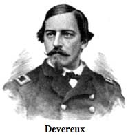 Parking is plentiful and is available road-side at intermittently enlarged shoulder cut-outs, usually marked with white striping. Be sure to keep vehicles off the grass or you will be ticketed by park police. I visited these flank monuments on Tuesday, August 7, 2012 at approximately 4:15 P.M. I was at an elevation of 581 feet, ASL. I used a Canon PowerShot 14.1 Megapixel, SX210 IS digital camera for the photos.
The 19th Massachusetts Infantry Monument (MN245-B) has two flanking markers. When looking at the flank monuments, the left flank marker is to the right of the monument if you are facing the east and the front of the monument but this is not the correct perspective from which to consider the original troop positioning on July 3, 1863. The Rebel came from the west when the attacked so one would stand in back of the monument and face west to get the correct perspective of the left and right flank markers and understand their positioning. The posted coordinates for the waymark are for the left flank marker which is 71 feet south from the primary monument. The coordinates for the right flank which is 75 feet north of the primary monument are N 39° 48.702 W 77° 14.124. The right flank marker is a foot from the 42nd New York Infantry left flank marker. The monuments were all dedicated on October 1, 1891 by the Commonwealth of Massachusetts. The flank markers are composed of granite, smooth all around with inscriptions on the front face and are a few feet high with a peaked top, like gables on a house roof. They resemble grave stones. The inscriptions are on the front faces which simply read: 19th MASS INFY RIGHT. and 19th MASS INFY LEFT.. Additional details from the nomination form concerning the flank monuments may be found from the NRHP narrative and are shown in red.
The 19th Michigan Infantry Regiment and its flanking monuments are a contributing features to the Gettysburg National Military Park Historic District which is nationally significant under NR Criteria A, B, C & D. Areas of Significance: Military, Politics/Government, Landscape Architecture, Conservation, Archeology-Historic. Period of Significance: 1863-1938. The original National Register Nomination was approved by the Keeper March 19, 1975. An update to this nomination was approved by the Keeper on January 23, 2004. The monument and flank markers are identified as structures number MN245-B.
From the Nomination Form:
1 of 25 Massachusetts Mn. Indicates position held by 19TH Mass. July 3, 1863 before & during Longstreet's Assualt. Located E side Hancock Ave, near Copse of Trees. LF&RF markers 66' & 67' N-S of Mn, respectively. [Actually, the LF&RF markers are 71' & 75' N-S of the monument, respectively.]
Short Physical Description:
Mn & 2 flank markers. Rough cut base 4'x5' w/tooled edges. Chamfered shaft w/flat face & incised inscription in polished stone and angle has detail of knapsack & bugle. Sculpt. cartridge box rests at top. All 7'H. LF&RF 1'6"x8"x2'2", polished face, gable design.
Long Physical Description:
Monument that has two flanking markers. Monument is a chamfered granite shaft with a flat face topped with a cartridge box and set on a 4x5 foot rough cut base with tooled edges. The shaft has an incised inscription in polished stone and the angle has a detail of a knapsack and bugle. Overall height is seven feet. Flanking markers are 1.6x.8 foot with a polished face and gable design. Located on the east side of Hancock Avenue, near the Copse of Trees.
My Sources
1.
NRHP Nomination Form
2.
SIRIS
3.
Stone Sentinels
4.
Virtual Gettysburg
5.
Draw the Sword
6.
Historical Marker Database
7.
Wikipedia