
Battery B, 1st New York Artillery Left & Right Flank Markers - Gettysburg, PA
N 39° 48.630 W 077° 14.148
18S E 308617 N 4409116
These 2 flank markers are on either side of the Battery B, 1st N.Y. Artillery Monument. The monuments records the left & right most positions of this unit's line on July 3, 1863 when defending this position on Cemetery Ridge against Pickett's Charge.
Waymark Code: WMGH19
Location: Pennsylvania, United States
Date Posted: 03/05/2013
Views: 6

The 1st New York Artillery, Battery B was also known as The Empire Battery. During the battle of Gettysburg, it served as a member of Hazard’s Brigade in the Second Corps, Army of the Potomac. The battery was commanded by Captain James McKay Rorty (1837-1863). Rorty was a book canvasser in New York City, a job he described as "crippling my intellect". He wounded at Fredericksburg and killed on July 3 during the final day of battle of Gettysburg. Rorty was buried close to where he fell. A few weeks later Richard Rorty, James' brother, came to Gettysburg and returned his body to New York, where it was laid to rest among many other Irish heroes of the Civil War in Calvary Cemetery. Under Rorty's limited command, 114 men (and 20-pounder Parrott rifles) were engaged at Gettysburg and among them 10 men were killed and 16 were wounded.
The 15th Massachusetts Infantry Monument and these flank markers are located on the left or west side of  Hancock Avenue (RD310) if traveling north along the road at the beginning of an area called The Angle. The sculpture is flanked on either side by two reproduction 20-pounder Parrott rifles, and then further out are these flank monuments. This monumentation is part of a string of monuments that extend a hundred feet or so south and north (west of this position) across the green field to the United States Regulars Monument (MN235) and beyond. All totaled, there are about 1080 feet of green fields with a line of monumentation spread across it representing the line of union regiments who defended Cemetery Ridge at The Angle against Longstreet's assault also referred to as Pickett's Charge on July 3, 1863, the final day of the Great Battle.
  Parking is plentiful and is available road-side at intermittently enlarged shoulder cut-outs, usually marked with white striping. Be sure to keep vehicles off the grass or you will be ticketed by park police. I visited this monument on Tuesday, August 7, 2012 at approximately 3:48 P.M. I was at an elevation of 581 feet, ASL. I used a Canon PowerShot 14.1 Megapixel, SX210 IS digital camera for the photos.
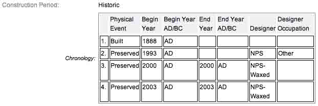
The Battery B, 1st N.Y. Artillery Monument (MN240-D) has two flanking markers. The posted coordinates for the waymark are for the left flank marker which is approximately 42 feet from the primary monument north of its position. The coordinates for the right flank which is approximately 48 feet north of the primary monument are N 39° 48.645 W 77° 14.142. The monuments were all dedicated on July 3, 1888 by the State of New York. The flank markers are composed of granite, are not very tall, almost cube like, with the top faced being polished and holding the inscriptions, the sides, roughly hewn. Additional details from the nomination form concerning the flank monuments may be found from the NRHP narrative and are shown in red. The inscriptions simply read: BAT. B/N.Y.A./L.F. and BAT. B/N.Y.A./R.F..
The Battery B, 1st New York Artillery Monument and the two flank markers are contributing features to the Gettysburg National Military Park Historic District which is nationally significant under NR Criteria A, B, C & D. Areas of Significance: Military, Politics/Government, Landscape Architecture, Conservation, Archeology-Historic. Period of Significance: 1863-1938. The original National Register Nomination was approved by the Keeper March 19, 1975. An update to this nomination was approved by the Keeper on January 23, 2004. The monuments are identified as structures number MN240-D.
From the Nomination Form:
1 of 90 Mn to New York. Indicates position held July 3, 1863 during Lonstreet's Assault. LF&RF at 41'&43' N-S to mn, respectively. Cannons N-S of Mn. Mn located W side of Hancock Ave.
Short Physical Description:
MN w/2 wrought-iron rifled cannon mounted on cast-iron carriages & 2 markers.
Long Physical Description:
Base stepped 6'8" sq, 2nd part rough cut. 2 part granite shaft, 2nd part 4 inverted cannon tubes at corners, 4 sides w/excised polished inscriptions, topped w/bronze medallions & 2nd Corps trefoil symbol. All 11'H. LF&RF 1'sq x 1'6"H
My Sources
1.
NRHP Nomination Form
2.
SIRIS
3.
Stone Sentinels
4.
Virtual Gettysburg
5.
Draw the Sword
6.
Historical Marker Database
7.
New York State Military Museum