
The 3rd Maine Infantry served as a member of Ward’s Brigade in Birney’s Division of the Third Corps, Army of the Potomac, a Fighting 300 Regiment. The unit was commanded by Colonel Moses B. Lakeman (1828-1907). Lakeman took over the brigade on July 3rd, and Captain William C. Morgan took command of the regiment. The 3rd Maine was one of several regiments from Third Corps moved from a reserve position to the point of attack on July 3. The unit has 266 men engaed at Gettysburg with 18 killed, 59 wounded and 45 who went missing.
The 3rd Maine Infantry Position Marker is located 48 feet off of  Hancock Avenue (RD310), on the right or east side of the road if traveling traveling north, stuck in the grass. This position monument is 42 feet southeast of the the 1st Pennsylvania Cavalry Monument (MN225-B). This position is also exactly 159 feet northeast of the High Water Mark Monument (MN230). The monument faces due west, in the direction where the Union position was defended on July 3, 1863. This area is an absolute beehive of activity as this site represents the best of what Gettysburg has to offer, both historically and monumentally.
 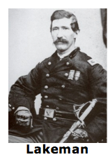 Parking is plentiful and is available road-side at intermittently enlarged shoulder cut-outs, usually marked with white striping. Be sure to keep vehicles off the grass or you will be ticketed by park police. I visited this monument on Tuesday, August 7, 2012 at approximately 4:51 P.M. I was at an elevation of 611 feet, ASL. I used a Canon PowerShot 14.1 Megapixel, SX210 IS digital camera for the photos.
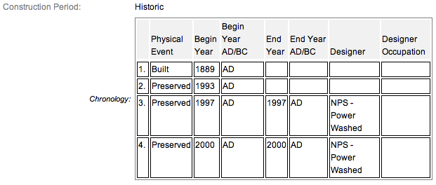
Often, state regiment monuments are also accompanied by secondary monument which designate positions maintained from July 1-3, 1863 as well as flank monuments to delineate the ends of troop lines. The primary 3rd Maine Infantry Monument (MN241-B) has two flanking markers, and two position markers, this one and another found elsewhere. This is the larger of the two position monuments and certainly more aesthetic. This Third Day marker lies 1.15 miles northeast from the primary monument located in the Peach Orchard. The monuments were all dedicated on October 23, 1889 by the State of Maine. The markers are composed of granite. The inscription is incised on a shield of gray supported by a roughly hewn and slanted base on flat base about 4 or so inches high and a few feet deep. The top of the base is smooth and its sides are rough. The is a red granite diamond symbol of the Third Corps appearing in the center of the inscription. Additional details from the nomination form concerning the flank monuments may be found below in red. The inscription reads:

The 3rd Maine Infantry Monument & position markers are contributing feature to the Gettysburg National Military Park Historic District which is nationally significant under NR Criteria A, B, C & D. Areas of Significance: Military, Politics/Government, Landscape Architecture, Conservation, Archeology-Historic. Period of Significance: 1863-1938. The original National Register Nomination was approved by the Keeper March 19, 1975. An update to this nomination was approved by the Keeper on January 23, 2004. The monument and markers are identified as structures number MN177-D.
From the Nomination Form:
1 of 15 mns in Park honoring Maine commands. Marks where regiment was engaged on July 2, 1863, at SW corner of Peach Orchard. Pitzer Woods position marker on Berdan Av marks morning of July 2. E side of Hancock Ave marker marks regiment on July 3.
Short Physical Description:
Mn, 2 flank & 2 position markers Mn: Rough-hewn base, 5'x5'x1'6" & tappering granite shaft, 2'6" sq 8'1" high, topped w/inverted Corps Diamond Lozenge. Polished inscription panels on N & S side of shaft Overall 13'1" high. Position markers, 2'x2'x2'. Flank markers, 1'x1'x2'.
Long Physical Description:
Monument that has two flanking markers and two position markers. Monument is a 2.6 foot tapering granite shaft that is 8.1 foot high and topped with an inverted 3rd Corps Diamond Lozenge set on a 5.5x1.6 foot rough hewn base. The shaft has polished inscription panels on the north and south sides. Overall height is 13.1 foot. Flanking markers are one foot square. Position markers are two foot square. Monument located at the southwest corner of the Peach Orchard. One position marker located in Pitzer Woods on Berdan Avenue andthe other position marker is found on the east side of Hancock Avenue.
My Sources
1.
NRHP Nomination Form
2.
Draw the Sword
3.
Historical Marker Database