
APPLEGATE TRAIL - CAMPT Historical 'T' Marker - Siskiyou County, CA
N 41° 54.143 W 121° 39.203
10T E 611694 N 4639815
This historical 'T' marker is located just off of Dorris Brownell Rd in Siskiyou County, CA.
Waymark Code: WMFNC8
Location: California, United States
Date Posted: 11/08/2012
Views: 1
This historical marker is part of a series of historical 'T' markers by the Trails West Historical Group who's mission is to place 'T' markers along immigrant trails leading west into Nevada, California and Oregon. The group also sells trail books for followers who are interested in re-enacting various immigrant trails from beginning to end.
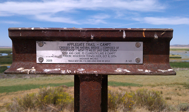
The Applegate Trail 'T' marker text reads:
APPLEGATE TRAIL - CAMPT
"CROSSED ON THE NATURAL BRIDGE ... COMPOSED OF
SOLID ROCK ... WENT 15 MILES HAD SOME STONY
ROAD AND CAME TO CLAMOUTH LAKE & CAMPT"
-PHOEBE HOGEBOOM TERWILLIGER, OCT 8, 1854
GUIDEBOOK AVAILABLE
2009 ---- TRAILS WEST INC. P.O. BOX 12045 RENO NV 89510 ---- A-48
This 'T' marker is one of many I have discovered in California and Oregon. The goal is to hopefully waymark more of these historical markers over time as I come across them. There is also another great website run by the Oregon-California Trails Organization (OCTA) which includes an interactive tour of all the emigrant trails that led into Utah, Nevada, California and Oregon from the mid 1800s. Click here to learn more history about these wonderful historic trails.
This particular section of the Applegate Trail is heading north back into Oregon along the Lower Klamath Lake Wildlife Refuge. Parts of Dorris Brownell Rd make up this historic Applegate Trail of yesteryear. The mention of 'Clamouth' Lake is referring to 'Klamath' Lake in the quote. Also, the mention of crossing over the natural bridge is referring to what is now the Anderson-Rose Dam that now covers this natural stone bridge that allowed emigrants to cross Lost River when water levels were lower during the dry season. There is a 'T' marker located there as well as some additional historical markers a 4-5 miles north of this 'T' marker on Malone Rd in Oregon.