|
 Gaudineer Picnic Area & Overlook - Monongahela National Forest - Durbin, West Virginia
N 38° 36.933 W 079° 50.629
17S E 600657 N 4274748
The Gaudineer Picnic Area is located on top of Shaver's Mountain in Pocahontas County in the midst of the Monongahela National Forest.
Waymark Code: WMER7F
Location: West Virginia, United States
Date Posted: 06/30/2012
Views: 2
Gaudineer Picnic Area & Overlook - Monongahela National Forest - Durbin, West Virginia
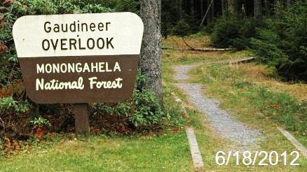
This picnic area and overlook is part of the fifty-acre Gaudineer Scenic Area atop Shaver's Mountain on the Greenbrier ridge of the Allegheny Mountains.
Picnic Area
Picnic Sites, which include a picnic table, grill and refuse container are scattered around the 1/2 Mile trail that surrounds the knob. A universally-accessible Vault Restroom is available in the parking lot.
Scenic Overlook
The Scenic Area and Overlook is named in memory of former Forest Manager D.R. Gaudineer,who lost his life protecting his family from harm in some way.
Caution !
Avoid this area when the wind is blowing as falling limbs or trees are likely due to the age of the old growth stands.
Estimated size of the public land (in regional measurement standard: hectares, acres, kms, etc.): 50 Acres

Is there a trail system?: No
What points of interest are there?:
Gaudineer Knob
Picnicking Sites
Virgin Spruce Trees
What activities are available?:
Picnicking
Wildlife and Nature Viewing
Hours of accessibility?: Sunrise-Sunset
List of known hazards (cliffs, snakes, poison plants, etc.):
Avoid this area when the wind is blowing as falling limbs or trees are likely due to the age of the old growth stands.
Dogs Allowed?: Yes
Is a permit/fee required?: No
Please supply the website of the land if available: [Web Link]
If there is a trail system, please describe length, terrain, etc.: Not listed
If a permit/fee is required please describe in detail how to get one, how much, etc.: Not listed
|
Visit Instructions:
Visitors are encouraged to supply a picture of either themselves or their GPS at the trailhead and/or signage of the public access lands - describe your experience there and what you saw - tell us why other folks should come visit!
Recent Visits/Logs:
| There are no logs for this waymark yet. |
|
|
|
|