
Spring Ridge Trail - Seneca Creek Backcountry - Monongahala National Forest - Western, West Virginia
N 38° 46.081 W 079° 33.675
17S E 624993 N 4292016
The Spring Ridge Trail is located in the Seneca Creek Backcounty of the Monongahela National Forest in West Virginia. This trail connects County Route 29 to the Allegheny Mountain Trail.
Waymark Code: WMER49
Location: West Virginia, United States
Date Posted: 06/30/2012
Views: 2
Spring Ridge Trail - Seneca Creek Backcountry - Monongahala National Forest - Western, West Virginia
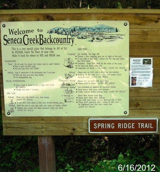
The Spring Ridge Trail gives a connection for hikers in the Seneca Creek Backcountry to connect to the Allegheny Mountain Trail on top, while the trail winds up the mountain through a hardwood forest where wildflowers are abundant in late spring and summer. The trail is three miles long
There is a parking lot at the trailhead.
Trailhead/trail website: [Web Link]

Trail allowances or restrictions:
Hiking, Biking and Pets
Trail type: Gravel / Old Road
Parking: Not Listed
|
Visit Instructions:
To claim a log for this waymark, some proof of a visit is required. This proof could be a simple photo of their GPS at the trailhead, a photo of the person at the trailhead, or a photo of a signature item that a person uses for photographs, at the trailhead.
In order to help other waymarkers who are looking for a nice hike/walk outdoors, you are encouraged to provide good feedback about the quality of the hike/trail.
Recent Visits/Logs:
| There are no logs for this waymark yet. |
|
|
|