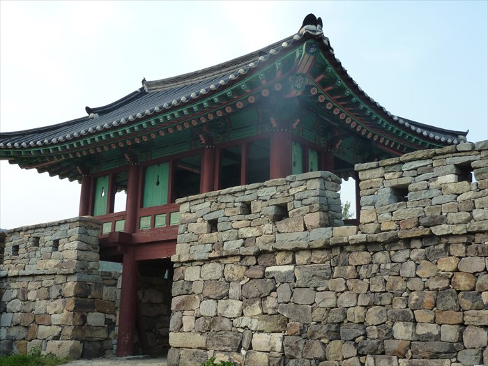
This fortress is unusual in that it is a wall that completely encircles an occupied village. Complete with houses, fields, gardens, Jindo dogs, cars and satellite dishes, this village offers the contrast of the ancient and the modern. Visitors here are free to explore some of the oldest buildings that have been preserved, the unusual entrance gate that is still intact, and see the details of the stone constructions. The local children can be seen running along the top of the wall.
This fortress sits at the tip of Jindo Island in a naturally protected harbor. It was an outpost to defend against the Japanese pirates during the reign of King Sejong. This location is a little off the beaten path, but the excursion is worth seeing a part of Korean history.
The Academy of Korean Studies has a high quality video over view of the fortress.
남도석성
사적 제127호
전라남도 진도군 임회면 남동리 149
성 이란 일정지역을 보호하고 행정이란 군사의 중심지로 활용하기 위해 돌이나
흙으로 쌓은 건조물을 말하다.
남도석성은 현재 남동마을을 감싸고 있는 평탄한 대지 위에돌로 축조된 성이다. 원
래 고려 원종 때 삼별초군이 진도에서 머물면서 해안 방어를 위해 쌓은 것이라 하며,
삼별초군이 제주도로 건너갈 때도 이곳에서 출발했다고 전해온다.
조선 초기에는 왜구가 해안을 자주 침범하여 해안과 섬 지방에 성을쌓고 수군을 파
견하였다.
당시 이 곳의 지명이 남도포 였으며 만호가 책임자로 파견되었기 때
문에 ‘남도포수군만호진성’ 이라 하였다. 기록에 의하면, 남도포에 만호가 처음 생
긴것은 조선세종20년 (1438) 정월의 일아다. 이로 미루어 보면현재남아있는 성은
세종 20년 아후에 쌓은 것으로 보아야 할것이다.
성의 둘레는610m, 노피는 2.8m~4.1m에 이르며, 성문과 옹성 (성문을보호하기
위한 시설) 등도 형태가 뚜렷하다. 남도석성은 수군만호진성으로는그 유적이 잘 남아
있어 보존 가치가 매우크다.
Namdoseokseong
Historic Site No. 127
Jeollanam-do, Jindo-gun, Imhoe-myeon, Namdong-ri 149
A fortress wall is a structure made of stone or earth for the purposes of
protecting the designated area and using that area as the administrative and
military center.
The Namdo stone fortress stands on flat ground which encircles Namdong
Village. It is said that this was build by the Sambyeolcho forces to defend the
coastal areas when they were stationed in Jindo during King Wonjong’s reign
and it is also said that this is the very spot that the Sambyeolcho left for Jeju
Island.
This fortress was reconstructed in the coastal regions and the naval forces
were dispatched here in the early Joseon Dynasty to repel Japanese pirates.
the then place name was Mandopo.
At the time, because the Manho (the commanding officer) was dispatched to
rule this area, it came to be called the Namdoposugunmanho jinseong (a naval
base in charge of Manh, ten thousand houses, at Namdopo). According to
the chronicle, it was in the 20th year of King Sejong’s reign (1438) that ten
thousand houses existed in this area. From this, it is believed that this
mountain fortress was built afterwards.
The stone fortress is about 610m around, and 2.8 to 4.1m high. The remains
of the gates and Ongseong (the outer wall to protect the fortress gate) are well
preserved. Unlike the other remaining Sugunmanhijinseongs it is good state
of preservation and for the reason, this fortress wall is worth being preserved.
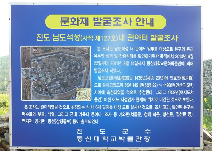
This aerial photo shows the overall structure of the fortress wall and the village within it.
The following additional information is available from the pages of
Data Korea.
Namdoseokseong Fortress was built in order to protect a coastal area when Sambyeolcho contended against Mongol in King Wonjong (1259~1274) of Goryeo. It was said that Sambyeolcho had left for Jeju-do passing this area. It was likely that there had already been three villages in Jindo in the Baekje Era. And this place was likely the center of one of them, from Baekje to the Goryeo Dynasty.
Judged from that facts, it was possible that the fortress had already been erected from the Three Kingdom Period. Government offices and people in Jindo had escaped to the other town in the 2nd year of King Chungjeong (1350) of Goryeo because of the Japanese pirates pillaged the town in the 13th century. They came back to Jindo in the early years of The Great King Sejong. Finally, Manhobu, the military alliance usually established along the coast, formed here and erected the fortress in the 20th year of King Sejong. It was likely that the present fortress was built after that.
Although it was 400 meters round, Namdoseokseong Fortress was considered as an important location to protect the coastal area. It had many valuable relics since it was the the major site of the east, west and south gate that had been well preserved.
고려 원종(재위 1259∼1274), 삼별초가 진도에서 몽골과 항쟁을 벌일 때 해안지방을 방어하기 위해 쌓은 성으로, 삼별초가 제주도로 옮겨갈 때 이곳에서 출발했다고 전해진다. 그러나 백제 때 진도에는 3개의 마을이 있었고 그 중 한 마을의 중심지가 이곳으로 여겨지는데, 통일신라를 거쳐 고려시대까지 이어져 오는 것을 보면, 삼국시대에 이미 성이 있었을 가능성이 크다. 13세기부터는 왜구가 나타나서 노략질을 계속해 오자, 고려 충정왕 2년(1350)에 진도의 관청과 백성들이 내륙지방으로 피해서 살다가 세종대왕 초에 돌아오기도 했다. 결국 세종 20년(1438) 해안지방에 주로 설치되던 군사조직인 만호부가 이 지역에 생기게 되고 왜구로부터 보호하기 위해 성을 쌓았는데, 지금 남아있는 성은 그 이후에 쌓은 것으로 여겨진다. 동·서·남문이 있던 자리가 잘 남아 있으며, 둘레가 400여m 정도이지만, 해안지방을 보호하기 위한 중요한 위치임을 보여주고 있는 유적으로 가치가 매우 크다. ※(남도석성 → 진도 남도진성)으로 명칭변경 되었습니다.(2011.07.28 고시)