
Petroglyph Point - Modoc County, CA
Posted by:  condor1
N 41° 50.700 W 121° 23.470
10T E 633564 N 4633818
Petroglyph Point is located in northern California, Modoc County just east of County Rd 126. Access via State Hwy 139, about 8 miles southeast of the small town of Tulelake.
Waymark Code: WM7P6A
Location: California, United States
Date Posted: 11/16/2009
Views: 22
Text from the Information Sign:
You step into the past when you view the carvings in the cliff at Petroglyph Point. This formation was created when a cinder cone erupted from the floor of ancient Tule Lake to form an island. Early people paddled out in boats to carve these pictures into the soft rock. Waves undercut the base of the cliff where the petroglyphs are carved. Wind, rain, and ice have enlarged gas bubbles and faults, creating many cracks and crannies. These natural nesting sites are filled with barn owls, cliff swallows, hawks, prairie falcons, and many other birds who find an abundant supply of food nearby. A brochure is available at the site to help you better understand the significance of the area. You will long remember your visit to this special place.
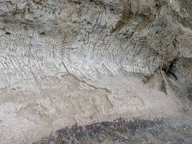
Pictograph or Petroglyph?
There are two types of rock art, or rock imagery, found at Lava Beds National Monument. Petroglyphs are carved or pecked, and pictographs are painted like a picture. All of the Monument’s rock imagery is located in the traditional territory of the Modoc people and their
ancestors or predecessors.
Petroglyphs are often located on cliff faces and boulders along the ancient shoreline of Tule Lake. They are most abundant in the northeast corner of the Monument here at Petroglyph Point. With over 5,000 individual carvings, this site is one of the most extensive
representations of Native American rock art in California.
The following link, compliments of the National Parks Service provides more detailed information on the immense display of petroglyphs.
NPS - Rock Art
Another great wealth of fantastic pictures concerning this petroglyph display can be found at the following link
California Blog
The National Park Service provides a brochure explaining this Petroglyph Site. It is in PDF format and well worth the read...Link -->
NPS - Images in Stone
There is a chain link fence surrounding this petroglyph gallery. It was placed to try to keep vandalism from damaging the ancient rock art. All of the pictures for this waymark were taken through the fence, so there should be no problem taking your own pictures when you visit this site.
Visit Instructions:1. You may log as many different waymarks as you wish but you may only log each one once.
2. You must include a close up photo of the pictograph and your GPSr. The pictograph must be recognizable.
3. Tell a little bit about what you learned of the area.