Mt. San Antonio, a.k.a. Mt. Baldy, California
Posted by:  showbizkid
N 34° 17.340 W 117° 38.764
11S E 440539 N 3794389
Mt. San Antonio is a 10,064 foot peak in the San Gabriel Mountains in the Angeles National Forest.
Waymark Code: WM6FW
Location: California, United States
Date Posted: 01/24/2006
Views: 187
Mt San Antonio is the highest point in Los Angeles County and in the San Gabriel Range. The mountain is more commonly called “Mt. Baldy,” “Old Baldy” or just plain “Baldy” because the white top of the mountain above the tree line makes the mountain appear “bald.” Once you get up there, you see very little vegetation. It is pretty bald.
These are the "easy" directions to climb the peak. From about May through November, the Mt. Baldy ski lift runs on weekends to ferry people up to Baldy Notch. From there it is a fairly easy climb up to the peak. Even with the ski lift hop, this is not a stroll in the woods. The elevation is pretty high and the air is thin. The Devil Backbone portion of the trail can be dangerous in wet or snowy conditions with very steep drop-offs on both sides. This hike is for those in good physical condition who can manage a fairly strenuous hike with some steep portions at altitude.
For true peak baggers, this is the wimpy way to go, but hey, not all of us are Iron Men (or Women).
- Take the 210 Freeway to the Mountain Avenue/Mount Baldy exit in Upland</li
- Head North towards the mountains
-
Mountain Avenue will turn into Mt. Baldy Road and dead ends at the Ski Area Parking Lot. Park here.
Take the ski lift ($12 round trip) up to Baldy Notch- Once at Baldy Notch, turn left (northwest) and follow a road up a ridge to where it becomes a trail
- Follow this trail up the Devils Backbone, going by Mt. Harwood on your right (to the north), and up to the summit
The hike is about 7 miles round trip and the elevation gain is about 2300 feet.
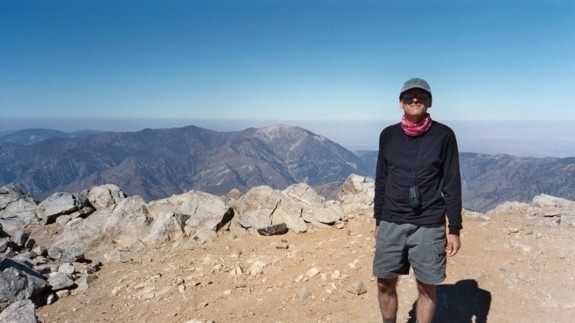
Once on the peak, there’s an old plaque with the elevation where you can have your picture taken.
On busy weekends when the weather is nice, you'll see quite a few climbers who decided to take one of the hard routes up the mountain. They're usually collapsed on the ground, wiped-out from the climb. This'll make you feel better for having taken the "easy" route up via the ski lift.
Don't forget to have your picture taken on the peak to record your visit to this waymark.
For more details on the history of the peak, here’s the link for the Sierra Club Summit Signatures Webpage for Mt. Baldy. For those wanting the balls-out, you’ll-be-sore-for-days hike, here’s a link for the Sierra Club Webpage for Mt. San Antonio. There are four different hikes on this page.
For those who search such things, Mt. Baldy hosts a long-standing GEOCACHE.
To record your visit to this waymark, post a photo of yourself on the peak. GPS in shot is nice, but not mandatory. Historic visit are okay as long as there's photographic proof of your visit. Logs without photos will be archived.
Me on the peak: