
Kornati - Nacional Park, Croatia
Posted by:  I3oris
N 43° 52.000 E 015° 12.000
33T E 516070 N 4857083
Kornati - nacionalni park, Reublika Hrvatska
Waymark Code: WM606J
Location: Croatia
Date Posted: 03/10/2009
Views: 22
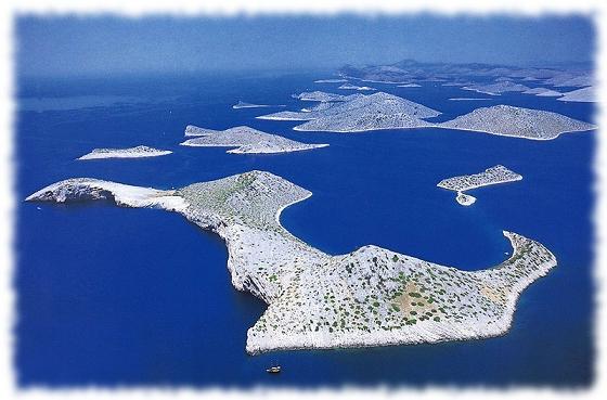
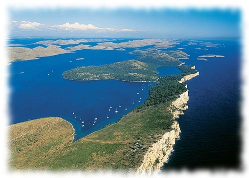
Stretching
along the central part of the Croatian Adriatic, are the
Kornati islands.
With their immense natural beauty, diverse coastlines, and
preserved marine ecosystem, most of the Kornati islands were
declared a National park in 1980. National park Kornati sizes
about 220 km2 which consists of many islands, islets and
reefs. National park Kornati was named after the biggest
island in the group. This area is a specific geological
phenomenon. Some of the past geological events in this area
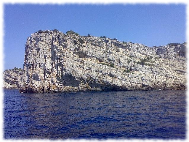
are strikingly reflected in the well-known Crowns of Kornati.
The vertical cliffs of Kornati islands facing the open sea are
the most popular phenomenon of this park. The Crowns are
actually the surface of a large tectonic fault stretching from
Istria and ending somewhere in Central Dalmatia (perhaps even
further to the south), caused by the global movement of Africa
to the north and its “crashing” into Europe. Vegetation on the
islands is minimal, giving the islands a bald look, however,
nature still thrives with plant life on the rocks. Crystal
clear water, and uncover the all kinds of reefs, shellfish and
many species of fish below the surface.
The Kornati islands were populated in prehistoric times; findings
of stone hatchets at the bottom of the hill Pasinka on the islands
of Kornati confirm the stated. The Kornati islands were a frequent
target for invaders and thieves, from the Romans and the Venetians
to the aristocracy from Zadar. Although today the Kornati islands
are only populated during the summer months, old field and fishing
houses spread out in secluded inlets on the Kornati islands, give
away the presence of their owners. There is no electricity or fresh
water springs on the islands.
The Kornati islands are a real heaven for yachtsmen, divers and all
those who enjoy the solitude of untouched and the magnificence of
nature. There are 20 restaurants on the Kornati islands which serve
fish specialities. You can get to the Kornati islands by boat (if
you own or you rent), or by organised boat excursions offered by
tourist agencies. For more information you can visit the public
bureau „Nacionalni Park Kornati “in Murter. The park is located
about seven nautical miles from the island of
Murter.
Interesting
things to see:
Islet of Taljuric - because of its oval shape it
looks like a plate. It is dangerous for boats, because it is often
covered with water.
Island Piskera - is the second largest island in
the national park, it was once the main fishing centre on the
Kornati islands with a warehouse for salted fish.
Mala (little) Proversa – is a shallow passage
between Dugi (long) island and the island of Katine. Ancient Roman
ruins approximately 90m long are visible in the sea, which were
once above sea level.
Bay of Spinuta - in the bay, leftover wall ruins
are visible of an Ancient Roman salt factory or of a fish
cultivating pond
Visit Instructions:A log will require a recent photograph at the coordinates. Some of these locations will be placed for the scenery, so a gpsr will just ruin the picture.
If you don't have a digital camera post a descriptive log.