
Dart Hut
Posted by:  StagsRoar
S 44° 31.281 E 168° 33.268
59G E 305655 N 5067310
Dart Hut is sited near the head of the Dart Valley in the shadow of the Forbes Mountains of Mount Aspiring National Park.
Grid reference: Topo50 map sheet CA10, E1246716, N5060574
Waymark Code: WM5KH
Location: South Island, New Zealand
Date Posted: 01/03/2006
Views: 71
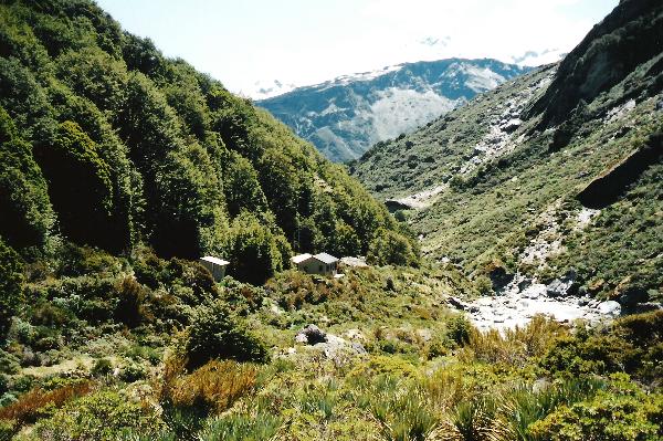
This hut is at the head of the popular Rees-Dart Valley track which during the summer particularily sees a considerable amount of traffic. I have only done this track during the summer season and therefore would assume that there would be less usage during the winter. In that, I would also assume that reserving a hut ticket for the night would not be as imperative but during the summer it is a must. Hut wardens are on site during the summer season as well. The Rees-Dart Valley walk has numerous huts along it's course and I will not list each of them as a waymark but the link for the whole walk can be seen
here. I think the reason I list this hut specifically is because of all the huts on this track, I favoured this the most due to the amount of stunning sub-alpine flora between the hut and the Rees-Dart saddle. The track as I have done it begins at Muddy Creek car park on the Rees River valley and the first day is a fairly flat 7 hour walk to Shelter Rock Hut and then the next day walking the 5 hours to the head of the valley, crossing the saddle and then back down the Dart Valley to the Dart Hut. The whole trip up the Rees, although fairly flat, is on an upward gradient. Once the Rees saddle (1450 metres) has been reached, in which you will by this time be thoroughly relieved, then it is a pleasant downward walk firstly through tussock and then into the sub-alpine scrub before hitting the hut which isn't far away. During summer the sub-alpine scrub is nothing sort of a botanical garden of native sub-alpine flora and presents lots of Photo opportunities. The hut when reached is a serviced 32 bunk hut with a fireplace. You will need your own gas cookers and be prepard to maybe having to sleep on the floor if the hut is full. (Cart along a bed roll maybe). The scenery here is great when the weather is good but fog and cloud can reduce the asthetic effects quite markedly. The walk out the valley from here invloves a 8 hour walk to Daleys Flat hut and then approx 5 hours to Chinaman Road carpark - which is NOT where you started so transport would need to be organized. Chinamans Bluff , incidently, does have a Rock Bivvy but I cannot remember the condition or status of it - but it is there. Alternatively (which is how I did it) is the go by jet boat from the bottom side of Chinamans Bluff and then via kayak-canoe down to Paradise. There are operators in Glenorchy with whom all this can be organized. The whole track is fairly well established with it's tracks and the route up and off the saddle is a poled route marked by orange waratahs (Y-poles). The footbridges are good with dry feet being maintained in the summer when I did it. More info and hut tickets etc can be obtained from the Queenstown
Department of Conservation.