
North Borland Hut
Posted by:  StagsRoar
S 45° 40.599 E 167° 29.200
58G E 693665 N 4938870
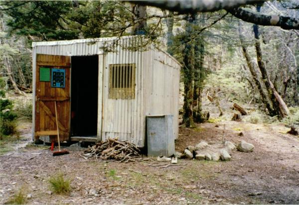
A small Hut located up the North Borland Valley near Lake Monowai in Fiordland.
Waymark Code: WM59E
Location: South Island, New Zealand
Date Posted: 12/26/2005
Views: 59
The start of the walk to this hut begins about 500 yards or less from the
Borland Lodge. The first thing you need to know about this hike is the signpost at the start says that the walk to this hut is something like 5 hours or so - I can't remember now, but whatever it says is quite wrong, unless of course it has been changed since I have seen it. It is a walk of 9hrs approximately to get in. Coming out of the valley maybe less due to the downward gradient but going in is certainly a lot more than posted. I thought that maybe it was just me being slow on the walk in, but the log book at the hut attests to the fact that others have found the same issues in terms of the time in - so give yourself more time. Second issue with this hut is that if you are using a
topographical map and have plotted the co-ordinates or if you have loaded the co-ordinates to your
GPS from Lands Information
New Zealand or any of the other Hut co-ordinate links available then let me tell you that the hut is not where it is sited on the map. It is in fact approx 1 1/2 kilometres further up the valley on the opposite side (true left) of the river. The co-ordinates I have posted for this hut are an approximation but they should about get you there give or take a hundred metres or so. If anyone visits this hut and has a GPS and can be more accurate with the co-ordinates then please let me know so that I may correct them.
If you have permission to leave your vehicle at the Borland lodge then also be sure to ask if there are any other parties up the valley that they know of as this hut is only a 2 Bunker and isn't really enough room for a dead cat to lie on the floor.
On beginning your walk you will drop down into the bush and soon cross Pig Creek and then hit the edge of the Borland River on the True Right bank. You will follow the river up on this side all the way up the valley until you hit the clearings near the head of the valley and close to the hut. This walk I must add is not for the faint or unfit either. You can actually shave about 3 kms off this walk by driving up the road for about that distance and entering the track along further but I think it is negligible as the track is quite flat and easy going for the first few kms anyway and is a good warm up. After about a couple of hours you will come across the Rock Bivvy which is marked on the Topo Maps at co-ordinates: S45*43.998,E167*30.241 or with New Zealand Map Grid Reference (sheet C44) 2082430,5482910. This Rock Bivvy should be a waypoint in itself but I was silly enough or to lazy to get the camera out of my pack and take photos of it. This very large overhanging rock appears to be dry as a bone in the rain and would easly sleep 6 people under it and is reasonably gaurded at the front by all the trees. I never stayed here but I wished I had. Would have been neat to sleep in the openness of this big overhang. Then about 500 metres or so on from this is the Middle Branch of the Borland which you will need to cross. There used to be a swing bridge over this side stream but the
Department of Conservation in all their infinitesimal wisdom removed it. It is after crossing this stream that some of the tough stuff of this walk begins. If the middle Branch is to high to cross at least you have the option of going back to the rock bivvy to wait till it drops or whatever. I won't go into it step by step but basically you slog on till you eventually hit the open clearings at approximate co-ordinates of: S45*41.505,E167*29.136. Hereafter the track fades and the route up the valley to the hut is marked by orange painted metal waratahs (Y posts) spaced out some distance up the the hut. At some point here you will have to cross the river also which is usually not to difficult. Once you get to the hut you will be relieved I assure you. The valley has no track on from here and is a 'walk in-walk out' type of valley although looking at the log book of the hut it can be seen that the occassional party has in fact carryed on up to the head cirque and climbed over into the Garnock Burn Valley. The weather is majorly unpredictable in this valley (as with most of
Fiordland) and looking at the photos I lodge with this waymark you will see that on one day it was fine (chilly but fine) and the next we got dumped with over a foot of snow - and this was in the beginning of summer!! The fireplace is a little ripper and will certainly warm you up in this little hut but don't be harsh on the surrounding bush when fossicking for wood - only use what you need and leave a bit of wood for the next peoples through. Look after this Hut when you are there as it would be a shame to have it wrecked or removed due to neglect. The walk in has plenty to take pictures of so keep your camera handy.
 No Dogs Allowed No Dogs Allowed  Hunting in area - use caution Hunting in area - use caution  Accessible in Winter Accessible in Winter
 Scenic View Scenic View  Compass & Topographical map Suggested / Required Compass & Topographical map Suggested / Required  Weather Permitting Weather Permitting  Approx 9 hour Hike Approx 9 hour Hike  Wear bug repellant! Wear bug repellant! |
| |