
Mt. Audubon Trail & Summit
Posted by:  Team Laxson
N 40° 05.951 W 105° 36.977
13T E 447470 N 4438947
Situated in the Indian Wilderness of Colorado's Front Range, Mount Audubon takes its place about one mile east of the Continental Divide and the resulting chain of rugged peaks that define the local geography.
Waymark Code: WM4P8G
Location: Colorado, United States
Date Posted: 09/14/2008
Views: 19
Unlike some of its neighbors, Mount Audubon is a gentle mountain that is best characterized by broad ridges and large expanses of tundra. As such, it is a mountain best appreciated by those who favor a leisurely stroll among the wildflowers over a hard scramble among the talus. Stunning views of the other peaks in the area can be had from the summit and this a good place to start thinking about future outings in the Indian Peaks. The true grandeur of the area is well revealed from Audubon and those who experience it will want to return.
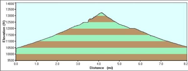
The hike begins at Mitchell Lake trailhead, and starts with a gradual climb towards the treeline. After 1 1/2 miles, you will reach the treeline and be exposed to the harsh wind that 11,200 ft above sea level offers.
After the treeline, you will be rewarded with amazing views of many different summits in all different directions.
Be prepared for steep inclines, gusty wind, and snow. I hiked this trail in September and there was 6-8" of snow on the trail, with drifts up to 3 feet deep.

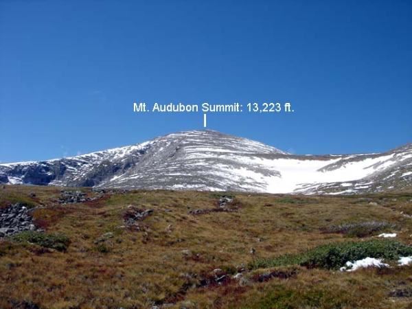
The view at the summit is breath-taking, as you can see for miles around in all directions. Absolutely Beautiful!
Key Waypoints
Trailhead: N40 05.024 W105 34.873
Treeline: N40 05.734 W105 35.071
Rock Scramble: N40 06.207 W105 36.818
Mt. Audubon Summit: N40 05.951 W105 36.977