
Walker & Bate at Sugar Cr. - GHM 044-55 - DeKalb Co., GA
Posted by:  Lat34North
N 33° 43.686 W 084° 19.217
16S E 748286 N 3735234
Walker & Bate at Sugar Cr. State Historical Marker located at Fayetteville Rd just north of Pine Trail at Sugar Creek.
Waymark Code: WM2T5G
Location: Georgia, United States
Date Posted: 12/17/2007
Views: 17
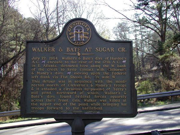 WALKER & BATE AT SUGAR CREEK.
July 22, 1864. Walker's & Bate's divisions of Hardee's A.C. [CSA] enroute to the rear of the 17th A.C. [USA] in East Atlanta, detoured here along the West bank of the creek to keep contact with Cleburne's & Maney's divisions [CSA] moving upon the Federal left flank via Flat Shoals Road, 3/4 mile West.
This detour was in sequence with the misdirected march of Cleburne's & Maney's troops and it entailed a circuitous by-passing of Terry's mill pond, northward of which, Walker's & Bate's divisions found Federal forces squarely across their front. General Walker was killed at the upper end of the pond while bringing his troops forward to the battlefield.
GHM 044-55 - Georgia Historical Commission - 1956