
Heceta Head/Cape Creek Bridge & Tunnel
Posted by:  TheBeanTeam
N 44° 08.070 W 124° 07.420
10T E 410114 N 4887425
Heceta Head Lighthouse and the historic Cape Creek Bridge and Tunnel were mentioned in the 1940's edition of the Oregon: End of the Trail American Guide Series publication.
Waymark Code: WM20DW
Location: Oregon, United States
Date Posted: 08/14/2007
Views: 43
"Rugged HECETA HEAD (520 alt.), 37.6 m., named for Bruno Heceta, the Spanish explorer who sailed near it in 1775, rises sheer above the ocean. HECETA HEAD LIGHTHOUSE, established in 1894, flashes its powerful beams for the benefit of mariners.
DEVILS ELBOW TUNNEL, 38.1 m., at the southern end of CAPE CREEK BRIDGE, is a 680-foot bore through a jutting headland. It is in the 35-acre DEVILS ELBOW STATE PARK. The highway swings around a cliff, high above the ocean, affording a startling land and sea view."Oregon: End of the Trail, 1940"
Excerpt obtained from the Oregon State Archives Exhibit: A 1940 Oregon Coast Tour
 Cape Creek Bridge & Heceta Head Lighthouse 1937
Photo Courtesy of Oregon State Archives, Oregon Department of Transportation, OHD0408
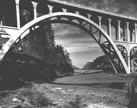
Just below the HECETA HEAD LIGHTHOUSE
and just north of the crook of headland named Devils Elbow is
a parking area beneath the Cape Creek Bridge. Coordiantes for this waymark are at this location.
Parking is available at the site but it does require a $3.00 fee or a State Parks Pass.
There is a hiking trail of 1/2 mile at this location up to
the lighthouse and over 7 additional miles of trail around
the area. The Cape Creek Bridge and Tunnel were engineering
marvels of the day and are listed on the National Register of
Historic Places.
Heceta
Head State Park is open to picnicking, surfing, hiking,
fishing, and lighthouse tours. The lighthouse keepers house is now
a bed and
breakfast and is available for overnight stays.
Microsoft's
Live Search maps provide a better aerial view of the area than
that available in the Google or Yahoo maps.
Don Bain's
Virtual Guidebook to the Oregon Coast shows a 360 degree
panorama view of this location from the
center of the Cape Creek Bridge including a view looking south into the tunnel at the end of the bridge.