
Doane's Falls - Royalston, MA
Posted by:  silverquill
N 42° 38.977 W 072° 12.071
18T E 729426 N 4725704
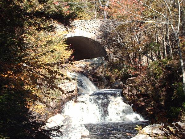
Doane's Falls is a cascade of over 200 ft on the Lawrence Brook as it passes under Athol Rd in Royalston, Massachusetts. It is part of a 46-acre tract managed by the Trust of Reservations. There are good hiking trails here, but no swimming or camping
Waymark Code: WM1QX8
Location: Massachusetts, United States
Date Posted: 06/26/2007
Views: 198
Property Description 46 acres | Established 1959
When the tranquil waters of Lawrence Brook reach Doane's Falls, they tumble in a sequence of dramatic waterfalls. Along the way, large boulders in the stream bed, small forested islands, and flat rock slabs divide the fast-rushing stream before it empties into Tully Lake.
On the southern bank of Lawrence Brook, just upstream from the falls, is Coddings Meadow, a little-known clearing in the wood that offers views of the quiet waters of Lawrence Brook and is an excellent launch site for exploring the brook by canoe or kayak. Further upstream, beaver dams dot the brook as it meanders through a wide red maple swamp.
The Reservation is named for Amos Doane who, in the early nineteenth century, owned land in the then-thriving manufacturing center of Royalston. He built a mill—an L-shaped structure, fifty feet long and more than four stories tall—above the falls for the manufacture of doors, sashes, and blinds. Though Doane's venture eventually failed, a series of previous mills—grist, saw, pail, and fulling—had successfully operated on the falls.
A half-mile trail leads down both sides of the stream. Moderate walking, strenuous in places. A three-quarter-mile woods road leads to the 14-acre Coddings Meadow along side of Lawrence Brook. Doane's Falls is a link in the Tully Trail.
An emergency telephone is located at the reservation's main entrance next to the upper falls.
The Trustees of Reservations manages the Tully Lake Campground on Doane Hill Road just west of Doane's Falls. Camping is not permitted at Doane's Falls itself.