
Kaitoke Regional Park - You Are Here - Rivendell, NI, New Zealand
S 41° 03.383 E 175° 11.605
60G E 348189 N 5453411
This set of covered information boards has a topographic-styled map of the Park.
Waymark Code: WM1AJGZ
Location: North Island, New Zealand
Date Posted: 08/26/2024
Views: 0
There are multiple signs on the winged display for the park that is commonly just called Rivendell - from it being widely used in the filming of the "Lord of the Rings". It highlights the lovely two rivers of the park, and the nature of the rainforest.
* What can you do here: Walking - it divides the options into Short Walks (of which there are five), Walking Tracks (two), and Tramping Track, and just a Route - experience and fitness required!
* Swimming in the Pakuratahi River is encouraged, with changing rooms just 30m away.
* Picnics and Camping - lovely film-set style areas.
* Bird Watching - you may find x30 native and introduced birds.
A quite detailed map by shading showing the relief/topography of the region has colours for the Native Forest, Forest Regrowth, and Grassland. The Legend has icons for: Park Entrance, Park Rangers Office, Locked Gate, Information Boards, Parking Toilets, Picnic Sites, Camping, Swimming, Rafting and Kayaking, and First Aid/ Defibrillator. A scale of 500 metres is added, with a North pointing arrow (at about a 1 o'clock orientation) It shows where you are, near the Swing Bridge, just up from Pakuratah Forks on the Hutt River Gorge.
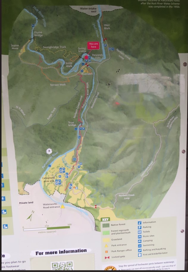
Detailed map of the Regional Park
Access: NOT available 24/7, as the park is closed from dusk to 6am - unless you are camping a few kilometres away, and want to take the road walk!
Visited: 1121, Monday, 29 July, 2024