
Mt Mangere Orientation Table #2 - Mangere, NI, New Zealand
S 36° 57.095 E 174° 46.897
60H E 302478 N 5908199
This framed pictorial Orientation Table is on the western edge of Mangere Mountain crater.
Waymark Code: WM1AC8Y
Location: North Island, New Zealand
Date Posted: 07/25/2024
Views: 0
The metal framed panoramic photo looking southwest to northwest from 'View Point 2' is mounted on a concrete slab atop cemented volcanic rocks in a low altar formation. It identifies various locations from the extinct volcanoes rim. A dirt/gravel winds up from the multi-use car park to the highest point. Going from SW to NW the identified places are:
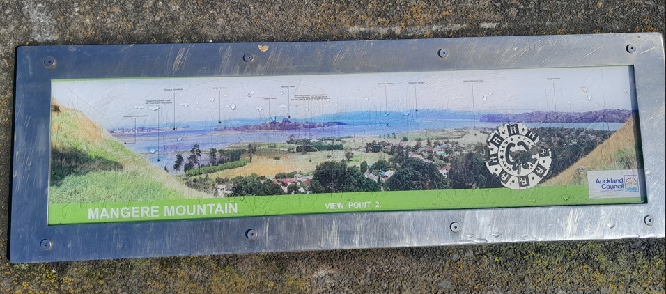
Cropped Orientation Table - View Point 2, Mangere Mountain
- Wastewater Treatment Plant
- Mangere Explosion Crater
with small stone cone centre
- Otuataua Stonefields
- Awhiti Peninsula
- Pukatutu Island
- Manaukau Heads
- Lava flow covered in volcanic dust from
Mangere Mountain. This rich agricultural
area was used by the Maori for growing kumara
- Manukau Harbour
- Waitakare Ranges
- Ambury Regional Park
- Mangere Bridge [suburb]
Visited: 1128, Tuesday, 23 July, 2024
[In the early 80's I had lived in Mangere Bridge and Mangere Central before moving back to Australia; we would frequently roam over Mangere Mountain.]