
Old Chain of Rocks Bridge
Posted by:  BruceS
N 38° 45.590 W 090° 10.459
15S E 745527 N 4293917
Historic Route 66 bridge crossing the Mississippi River between Illinois and Missouri north of St. Louis.
Waymark Code: WM19W0
Location: Missouri, United States
Date Posted: 03/09/2007
Views: 174
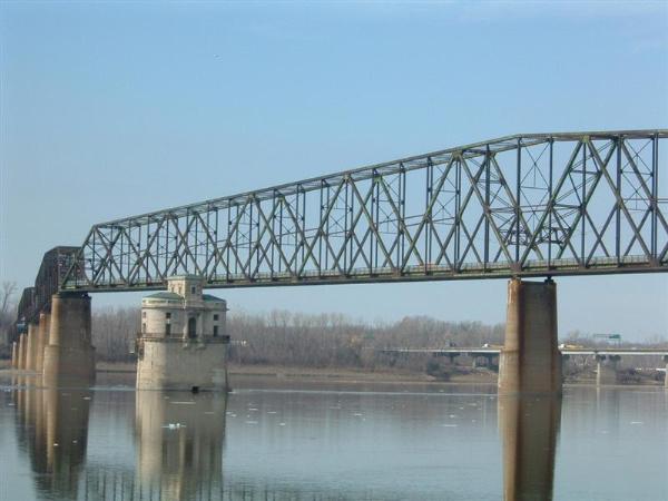
 "The
Chain of Rocks Bridge spans the Mississippi River on the north edge of St.
Louis, Missouri. The eastern end of the bridge is on Chouteau Island (part of
Madison, Illinois), while the western end is on the Missouri shoreline.
"The
Chain of Rocks Bridge spans the Mississippi River on the north edge of St.
Louis, Missouri. The eastern end of the bridge is on Chouteau Island (part of
Madison, Illinois), while the western end is on the Missouri shoreline.
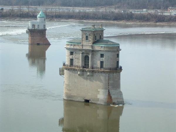
The Bridge was the most famous crossing of Route 66 over the Mississippi. Its
most notable feature is a 22-degree bend occurring at the middle of the
crossing, necessary for navigation on the river. The name comes from a "chain"
of rocks crossing the Mississippi just below the bridge — an exposure of bedrock
creating rapids in the river. Originally a motor route, it now carries walking
and biking trails over the river. The bridge was added to the National Register
of Historic Places in 2006.
 The
bridge was privately built as a toll bridge in 1929 at a cost of US$2.5 million
and later turned over to the city of Madison, Illinois, the current owner of the
bridge. In the late 1930s, Bypass US 66 was designated over this bridge and
around the northern and western parts of St. Louis to avoid the downtown city
(City US 66 continued to cross the Mississippi River over the MacArthur Bridge).
Eventually, the toll was removed from the bridge due to a law prohibiting the
collecting of tolls on US Highways. In 1967, the New Chain of Rocks Bridge was
built immediately to the bridge's north in order to carry I-270; the Chain of
Rocks Bridge was subsequently closed in 1967.
The
bridge was privately built as a toll bridge in 1929 at a cost of US$2.5 million
and later turned over to the city of Madison, Illinois, the current owner of the
bridge. In the late 1930s, Bypass US 66 was designated over this bridge and
around the northern and western parts of St. Louis to avoid the downtown city
(City US 66 continued to cross the Mississippi River over the MacArthur Bridge).
Eventually, the toll was removed from the bridge due to a law prohibiting the
collecting of tolls on US Highways. In 1967, the New Chain of Rocks Bridge was
built immediately to the bridge's north in order to carry I-270; the Chain of
Rocks Bridge was subsequently closed in 1967.
In 1981, the bridge was used in the shooting of the movie Escape from New York,
along with other sites in St. Louis.
Following the structure's closure, the bridge developed a reputation for crime
and violence, including the 1991 murder of sisters Julie & Robin Kerry.
In the mid 1990's, a Bigfoot monster truck drove over the "chain of rocks"
located just downstream from the Chain of Rocks Bridge.
For nearly three decades the fate of the bridge was uncertain, though demolition
seemed its most likely end. The high cost of demolition, however, indefinitely
delayed that outcome until a new use was found. In 1998, the bridge was leased
to a local trails group to operate. Four and a half million dollars have been
spent on renovating the bridge for pedestrian and cycling use. Occasionally,
motor tours for various Route 66 groups will be allowed use of the bridge." ~
Wikipedia
The bridge is accessible from either side of the river and is open from 1/2 hour
before sunrise to 1/2 hour after sunset. There are picnic tables available on
the bridge if a person wants the enjoy a lunch sitting over the river. The walk
across the bridges 5,353 feet is very enjoyable. During the months of December,
January and February it is common to see bald eagles wintering in the area.
The coordinates listed are on the middle of the bridge on the Illinois -Missouri
state line. To get a good river side view of the bridge go to N38° 45.381' W90°
10.306''
Note: When visiting the bridge I advise parking on the Illinois side of
bridge rather than the Missouri side. If parking on Missouri side of bridge
remove all valuables from your vehicle. This parking lot has one of highest
vehicle break-in rates in the city. Another advantage of parking on the Illinois
side is the close proximity to alternate river side viewing lot.