
Pacific Salmon Run Maze
Posted by:  Rose Red
N 47° 59.472 W 119° 37.393
11T E 304293 N 5318652
Chief Joseph Dam offers a roadside orientation center (on the Okanogan County side) off Highway 17, along with a labyrinth, maze and riverside trail.
Waymark Code: WM15PV
Location: Washington, United States
Date Posted: 01/24/2007
Views: 47
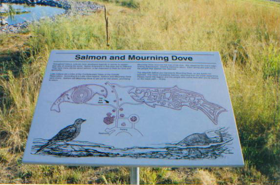
Chief Joseph Dam offers a scenic overlook just before Bridgeport, Washington (on the Douglas County side of the river) with children's playground, picnic area and rest rooms, and a roadside orientation center (on the Okanogan County side) off Highway 17, along with a labyrinth, maze and riverside trail.Adults and children have the opportunity to walk through the Pacific Salmon Run Maze to experience the life cycle of a salmon. Salmon and mourning dove exhibits at the orientation area describe the importance of salmon to American Indians as well as barriers to salmon survival.
Chief Joseph Dam is a 5,962 foot long hydroelectric dam spanning the Columbia River, 1.5 miles upriver from Bridgeport. The dam, originally called the Foster Creek Dam and Powerhouse, was renamed Chief Joseph Dam in honor of the Nez Perce chief. Like the nearby Grand Coulee Dam, Chief Joseph Dam ironically and illegally completely blocks salmon migration on the upper Columbia River. The dam is the second largest hydropower producer in the United States. It is operated the U.S. Army Corps of Engineers and the electricity is marketed by Bonneville Power Administration (BPA).
Instructions for logging waymark: A photograph is required of you (or your GPS receiver, if you are waymarking solo) and the place. Please let me know how accurate the coordinates are; they should be fairly good however I had questionable GPS reception.