The Place:
Dawson Creek, British Columbia is where the Alaska Highway officially begins. It stretches for 2,500 km (1,570 miles) from Dawson Creek
to Delta Junction, Alaska, via Whitehorse, Yukon.
First explored in 1793 by
Alexander Mackenzie, more than a decade later the Northwest Company's
Simon Fraser established trading posts in the Peace Country, in 1805. Through the 1800s missionaries, traders and other travelers visited the area, but it was not until it was visited by
George Mercer Dawson in 1879 that much attention was paid to the area. A geologist sent to the
Peace Country to gain information on the viability of constructing a railroad into the country, Dawson sent back glowing reports of "
grass up to the horses’ bellies, the hillside covered with wild asters, goldenrod, and Indian paintbrush; the deep valley soil and the native peoples. In appreciation, Dawson Creek was named for this eminent man."
Still, it was not until the onset of the
Klondike Gold Rush that settlement of any sort took place. A number of prospectors and fortune hunters attempted to reach the Klondike overland from Edmonton, a very arduous and dangerous journey to undertake. A few decided instead to settle in the Peace Country, becoming its first settlers.
When the Edmonton, Dunvegan and British Columbia Railway (Northern Alberta Railway) reached Spirit River, Alberta in 1916 settlements began to pop up beyond the rail head, including Pouce Coupe and Dawson Creek. The railway was slowly expanded into the region, while at the same time settlers were taking up land in the surrounding area. The land proved to be excellent grain growing country and not long after the railway arrived at Dawson Creek the hamlet boasted no less than five grain elevators. "
On Thursday, January 15, 1931, the first regular passenger train arrived at Dawson Creek over the N.A.R.".
Quoted sections above are from Dawson Creek History.
Today the second largest city in the British Columbia section of the Peace Country, Dawson Creek was incorporated as a City in 1958. It has become the shipping point and supply centre for the surrounding farming area, as well as a supply and storage centre for the regional oil and gas industry.
Dawson Creek grew slowly but steadily until March of 1942, when the village was invaded by a huge horde of U.S Army personnel with the intention of building a road to Alaska in hopes of being able to defend it should the Japanese choose to make a landing there. Dawson Creek was to be the starting point for the renowned
Alaska Highway.
 The Person:
George Mercer Dawson
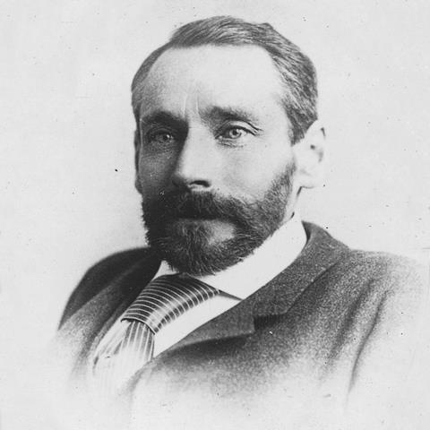
George Mercer Dawson, geologist (born at Pictou, NS 1 Aug 1849; died at Ottawa 2 Mar 1901), son of Sir John William DAWSON. He studied at McGill, then at the Royal School of Mines, London. His superior mental and observational powers became widely known from his work as a geologist and botanist to the International Boundary Commission, which surveyed the FORTY-NINTH PARALLEL from Lake of the Woods to the Rockies 1873-75. He accurately reported on the geology, mineral resources, agriculture and climate, including locust invasions, of the western plains.
In 1875 he joined the GEOLOGICAL SURVEY OF CANADA. His survey of BC strongly influenced government decisions on the proposed route of the CANADIAN PACIFIC RY. A charter ROYAL SOCIETY OF CANADA member (1882), Dawson by 1883 was assistant director of the GSC. In 1887 he surveyed the Alaska boundary at the Yukon River and investigated gold discoveries there. In 1892 he became British commissioner on Bering Sea natural resources, and in 1896, a member of the Ethnological Survey of Canada. He was also GSC director 1895-1901.
Dawson's brilliance in systematic mapping provided a sound basis for understanding the geology and mineral resources of much of northern and western Canada, and offered reliable guidance to mining, ranching, agricultural and lumbering industries. He also encouraged investigation and development of western coal and petroleum resources. The first comprehensive work on Canada's physiography,
Descriptive Sketch of the Physical Geography and Geology of the Dominion of Canada, was published by Dawson and A.R.C. Selwyn (1884).
From The Canadian Encyclopedia © 2021