|
 Okanogan, Washington - Bulldog Country Posted by:  T0SHEA T0SHEA
N 48° 23.557 W 119° 32.882
11U E 311381 N 5363076
Since 1914 the county seat of Okanogan County, the city of Okanogan stretches along the west (right) bank of the Okanogan River.
Waymark Code: WM102JV
Location: Washington, United States
Date Posted: 02/12/2019
Views: 1
This is the Town of Okanogan's welcome sign at the northern entrance to town. It stands on the northwest side of Highway 215, which here is also Elm Street, greeting visitors as they make their way into Okanogan from Omak, the larger city/town just a mile or so north. The Bulldogs are the sports teams of the Okanogan High School, which one will find 2.5 miles southwest and three blocks north of this welcome sign.
A city of about 2,600, Okanogan is not 2 miles south of the larger Omak, WA, which has nearly double Okanogan's population. Strangely, though, when the county seat was moved from the town of Conconully, it went to Okanogan, not Omak. It was the coming of the Great Northern in 1914 which caused the move of the county seat, as the tracks followed the Okanogan River Valley, in which Okanogan was located, but not Conconully. As a result Okanogan thrived and Conconully collapsed.
Established in 1886 as a trading post, the settlement was named Alma in 1888, after Alma Kahlow, the daughter of a prominent early resident and wife of an area sternwheeler captain. Alma's name was changed to Pogue in 1905, in honour of a leading citizen. Soon after, in 1907, residents voted overwhelmingly in favour of another name change, this time settling on Okanogan. That same year Okanogan was incorporated as a town. Prior to the arrival of the Great Northern, transportation in the valley was accomplished by paddlewheelers on the Okanogan River, Okanogan being about the northernmost point to which the ships could navigate.
Rough Lumber and Trails for Streets
...[Okanogan] was not an imposing sight in those early days. When H. A. Yates rode in to town in May 1906, he said "the town had all the appearance of being a real frontier settlement".
Harry J. Kerr, who later became Okanogan's first mayor and a prominent banker, stepped off a steamboat that same month. He wrote in his A History of Okanogan that he was at first "disappointed" in the looks of the town and surroundings.
"The thing I noticed first was the entire absence of paint or finished lumber," he wrote. "Most of the buildings I could see were of the box type and made of rough lumber. The streets were but trails in the sagebrush and rocks. The thought of starting a bank and trying to make a home in such surroundings looked rather discouraging"...
Okanogan Today
The city hosts the Okanogan County Fair every September at the fairgrounds north of town (not to be confused with the Omak Stampede, which is a rodeo and "Suicide Race" in August).
Okanogan's population has remained relatively stable over the last 50 years. It stood at 2,001 in the 1960 census and has since grown slowly and steadily to 2,484 in the 2000 census. The 2010 estimate by the state Office of Financial Management is 2,500, which puts it at a little more than half the population of Omak, estimated at 4,780. The Hispanic population is 10.1 percent, slightly higher than the statewide average, but far below the nearby cities of Brewster and Bridgeport, which are majority Hispanic...
...Meanwhile, the Okanogan County Historical Museum and Fire Hall remains the repository of the town's past. The complex includes historical exhibits, an Old West replica town, the Frank Matsura photo collection, and a research center.
From History Link
The hot, dry summers and mild winters of the Okanogan Valley, when irrigation was added, proved an excellent fruit growing area, which it remains today, with thousands of acres of apple, peach, pear, apricot, and cherry orchards having planted in the valley. In 1905, the Okanogan Irrigation Project was approved by the U.S. Department of the Interior, making it the first U.S. Reclamation Service project in the state. More recently it has proved to be an excellent grape growing area, with vineyards and wineries constantly popping up among the orchards in recent years.
Following is a view of the town from about 1940, composed by the writers of the American Guide Series Book, Washington: a guide to the Evergreen State.
OKANOGAN
OKANOGAN, 51.8 m. (829 alt., 1,735 pop.), the center of government in Okanogan County since 1915, is also headquarters for the Chelan National Forest. Though less populous than Omak, it has a larger and more impressive business district. The six blocks of brick and frame buildings occupy a narrow valley on a delta bar, at the mouth of Salmon Creek. The Okanogan River winds slowly and quietly a few hundred feet left of Second Avenue, the main thoroughfare. Across a steel bridge spanning the stream are rows of warehouses, packing plants, and the railroad tracks.
On a knoll west of the commercial center is the OKANOGAN COUNTY COURTHOUSE, a semi-mission type of structure in gray concrete, with a jail above the two floors of offices. An ornate cupola rises above the entrance, and expansive green lawns surround the buildings. On Queen Street, one block right of the highway, is the FIRST METHODIST CHURCH, a building of unusual design, faced with stones of varying shapes and sizes. The FIRE STATION, on Pine St. (R), is an old fashioned wooden building with square tower, erected in 1910. Many fine houses with landscaped grounds, shaded by weeping willows and poplars, occupy a sloping bench on one side of the town. Okanogan's leading hotel offers the "howdy-stranger-hitch-and-come-in" hospitality of the earlier West.
Situated approximately 20 miles from the site of the first American settlement in Washington Territory, Old Fort Okanogan, the town embraces the two prior settlements of Pogue and Alma. Okanogan began with the old trading post of "Pard" Cummings, established in 1886. At that time, river transportation was limited: only during May and June, when the water was high, could steamboats reach Okanogan. Consisting of little but a river landing and a general store for more than a decade, the settlement finally attracted other enterprises. Orchards blossomed near streams on the near-by flats. When irrigation from a reservoir at Conconully was obtained in 1906, it became a thriving town. The name Okanogan was adopted in November 1906. The Great Northern ran a branch line from Wenatchee in 1915, and the county seat was acquired, stimulating future growth.
From Washington: a guide to the Evergreen State, Page 456 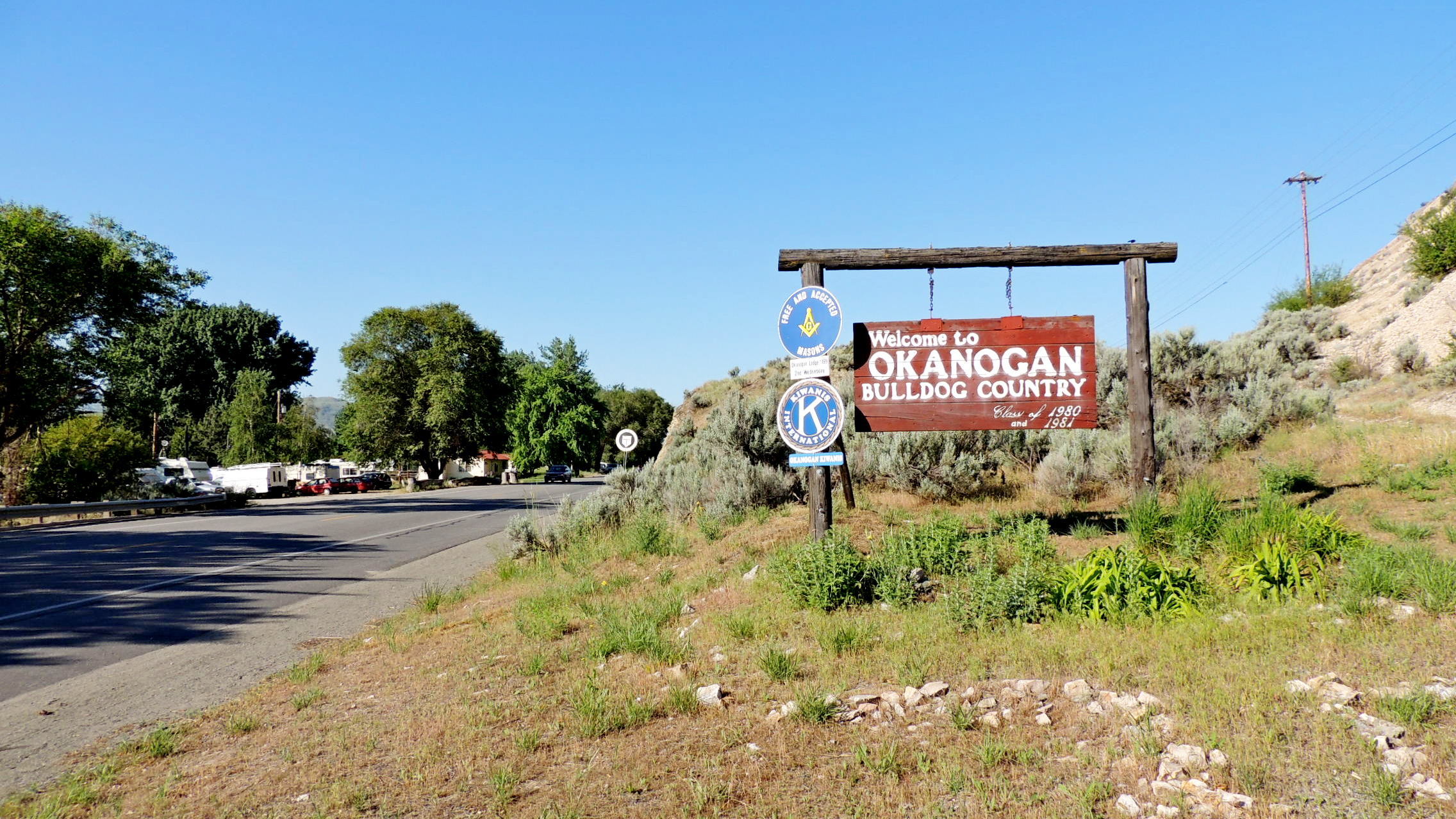
Type of community: Town

|
Visit Instructions:
More pictures of the sign would be great. Try and take a picture of yourself with it if you can!
Recent Visits/Logs:
| There are no logs for this waymark yet. |
|
|
|
|