 view gallery view gallery W4.3 km W4.3 km
|   Daniel Boone's Trail - Bernstadt. KY Daniel Boone's Trail - Bernstadt. KY
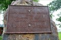
in Wagon Roads and Trails From North Carolina to Kentucky 1775. Erected by the Kentucky Daughters of the American Revolution 1915. posted by:  Crazy4horses Crazy4horses location: Kentucky date approved: 03/19/2023 last visited: never |
 view gallery view galleryW4.3 km |  Daniel Boone's Trail - Bernstadt, KY, USA Daniel Boone's Trail - Bernstadt, KY, USA
in Daughters of the American Revolution Daniel Boone’s Trail is the famous trail constructed by Daniel Boone and his party of pioneers in 1775. The Trail ran from Cumberland Gap to Fort Boonesborough. This is a sandstone rock on a concrete slab with a brass plaque and no DAR Insignia. posted by: Crazy4horses location: Kentucky date approved: 05/27/2023 last visited: never |
 view gallery view gallery SW11.1 km SW11.1 km
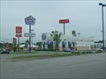
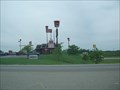
|  White Castle - London, Ky White Castle - London, Ky
in White Castle White Castle location in London, Ky just off interstate 75. posted by:  fatcat161 fatcat161 location: Kentucky date approved: 05/19/2009 last visited: 12/22/2011 |
 view gallery view gallery S11.6 km S11.6 km
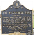
|  The Wilderness Road, London, Kentucky The Wilderness Road, London, Kentucky
in Kentucky Historical Markers A marker noting the significance of the first wagon road from the Cumberland Gap to the west. posted by: PersonsMD location: Kentucky date approved: 10/29/2010 last visited: 05/17/2016 |
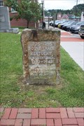 view gallery view galleryS11.9 km | Wilderness Road/Boone Trace Crossing-London, KY in Wagon Roads and Trails Located on the grounds of the Laurel County Courthouse posted by: Markerman62 location: Kentucky date approved: 05/25/2016 last visited: 05/21/2016 |
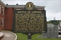 view gallery view galleryS11.9 km | Battle of London in Kentucky Historical Markers Located at the courthouse in London posted by: Markerman62 location: Kentucky date approved: 05/24/2016 last visited: 09/18/2022 |
 view gallery view galleryS11.9 km |  Battle of London - London KY Battle of London - London KY
in Battlefields 500 CSA cavalry led by Col. J.S. Scott attacked 200 USA troops and 98 convalescents under Col. L.C. Houk here Aug. 17, 1862, killed 13, wounded 17, captured 111 men and 40 wagons. posted by: Don.Morfe location: Kentucky date approved: 11/13/2020 last visited: 10/16/2021 |
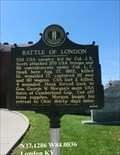 view gallery view galleryS11.9 km |  Battle of London - London KY Battle of London - London KY
in American Civil War Monuments and Memorials Marker is on the grounds of the Laurel County Courthouse, 101 S Main St, London KY 40741. It was erected in 1962 by Kentucky Historical Society, Kentucky Department of Highways. (Marker Number 560.) posted by: Don.Morfe location: Kentucky date approved: 07/30/2023 last visited: 07/30/2023 |
 view gallery view galleryS11.9 km |  Poynter Building - London KY Poynter Building - London KY
in U.S. National Register of Historic Places The Poynter Building, on Main St. in London, Kentucky, was built in 1910. It was deemed significant as the best example of turn of the century commercial architecture in London. posted by: Don.Morfe location: Kentucky date approved: 01/06/2021 last visited: 09/28/2021 |
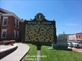
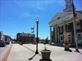 view gallery view galleryS11.9 km |  Laurel County Courthouse - London KY Laurel County Courthouse - London KY
in Courthouses In 2016, there were 954 circuit court cases processed (ranked #22 in the state of all the counties), and there were 12599 district court cases processed (#9 in the state). posted by: Don.Morfe location: Kentucky date approved: 09/25/2022 last visited: 09/18/2022 |
 view gallery view gallerySW12.6 km |  Cabin Creek Farm - London, KY Cabin Creek Farm - London, KY
in Alpaca and Llama Farms The girls raise Alpacas to earn pocket money. posted by: vhasler location: Kentucky date approved: 02/16/2009 last visited: never |
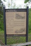 view gallery view galleryW13.4 km |  Camp Wildcat and the Wilderness Road-East Bernstadt, KY Camp Wildcat and the Wilderness Road-East Bernstadt, KY
in Signs of History Located on US 25 near Hazel Patch Rd north of London posted by: Markerman62 location: Kentucky date approved: 12/06/2020 last visited: 05/21/2016 |
 view gallery view galleryW13.4 km | Camp Wildcat and the Wilderness Road in Kentucky Historical Markers Located on US 25 near Hazel Patch Rd north of London posted by: Markerman62 location: Kentucky date approved: 11/21/2020 last visited: 05/21/2016 |
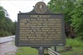 view gallery view galleryW13.4 km | Camp Wildcat/Union Civil War Camp in Kentucky Historical Markers Located on US 25 near Hazel Patch Rd north of London posted by: Markerman62 location: Kentucky date approved: 05/24/2016 last visited: 05/21/2016 |
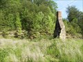 view gallery view galleryW14.2 km |  Hazel Patch Chimney, KY Hazel Patch Chimney, KY
in Lonely Chimneys This lone chimney sits near a large paved area at the junction of US-25 and KY-909 near Hazel Patch, KY. It appears that the attached structure burned down. posted by: onfire4jesus location: Kentucky date approved: 05/29/2008 last visited: 05/24/2008 |
 view gallery view galleryS14.2 km |  KFC - Highway 80 - London, Ky KFC - Highway 80 - London, Ky
in Kentucky Fried Chicken/KFC Restaurants Located just off I75. posted by: fatcat161 location: Kentucky date approved: 05/19/2009 last visited: 12/22/2011 |
 view gallery view galleryS14.2 km |  London, KY London, KY
in Small Town, Big Name As of the 2000 census, the city population was 5,692 (5,757 in 1990) according to the United States Census Bureau. Located in Southeastern Kentucky just North of the Tennessee State Line. posted by: BluegrassCache location: Kentucky date approved: 10/15/2007 last visited: 06/19/2021 |
 view gallery view galleryS14.2 km |  Snappy Tomato Pizza - London, KY Snappy Tomato Pizza - London, KY
in Pizza Shops - Regional Chains Little pizza parlor attached to the Shell gas station.
posted by: fatcat161 location: Kentucky date approved: 08/04/2009 last visited: 12/18/2011 |
 view gallery view galleryS14.5 km |  Wendy's - Dogpatch Trading Center - London, Ky Wendy's - Dogpatch Trading Center - London, Ky
in Wendy's Restaurants Just of interstate 75 in London, Ky. posted by: fatcat161 location: Kentucky date approved: 05/19/2009 last visited: 07/08/2016 |
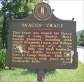 view gallery view galleryW15.1 km | Skaggs Trace, Ft. Sequoyah Indian Village, Kentucky in Kentucky Historical Markers A marker noting the ancient road or trace named for Henry Skaggs and early pioneer. posted by: PersonsMD location: Kentucky date approved: 08/29/2009 last visited: 05/17/2016 |
 view gallery view galleryS16.3 km |  London Corbin Airport, London, KY London Corbin Airport, London, KY
in Airports Small community airport serving the communities of London and Corbin Kentucky. LOZ posted by: PersonsMD location: Kentucky date approved: 09/04/2009 last visited: 02/20/2010 |
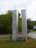 view gallery view gallery NW16.4 km NW16.4 km
|  Livingston, KY 9/11 Memorial Livingston, KY 9/11 Memorial
in 9/11 Memorial Sites Memorial located in a small rural community in southern Kentucky, along the Dixie Highway and Wilderness Road route. posted by: kbarhow location: Kentucky date approved: 09/17/2009 last visited: 10/20/2012 |
 view gallery view galleryNW16.4 km |  Livingston Trail Head Four Historic Plaques - Livingston, KY Livingston Trail Head Four Historic Plaques - Livingston, KY
in Ancient Traces and Roads Marker is on Daniel Boone Trail (U.S. 25) near Upper River Road (Kentucky Route 490), on the right when traveling north. marker is in a small park that serves as a trail head. It at the south west corner of the intersection. posted by: Crazy4horses location: Kentucky date approved: 03/20/2023 last visited: never |
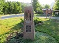 view gallery view galleryNW16.4 km | Livingston Trail Head Four Historic Plaques - Livingston, KY, USA in Daughters of the American Revolution Marker in on Daniel Boone Trail (U.S. 25) near (Kentucky Route 490) in a small park that serves as a trail head. The four plaques are on a pink granite monument. The plaques do not contain the DAR insignia. posted by: Crazy4horses location: Kentucky date approved: 05/27/2023 last visited: never |
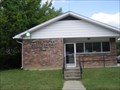 view gallery view galleryNW16.6 km |  Livingston, Kentucky 40445 Livingston, Kentucky 40445
in U.S. Post Offices A small community Post Office in the deep green woods of Kentucky. posted by: PersonsMD location: Kentucky date approved: 08/28/2009 last visited: 10/09/2013 |
|