 view gallery view gallery NW52.9 km NW52.9 km
|   Tuba City, AZ 86045 Tuba City, AZ 86045
in U.S. Post Offices Located near the BIA office in town. posted by:  ChapterhouseInc ChapterhouseInc location: Arizona date approved: 04/12/2011 last visited: 03/14/2011 |
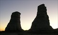 view gallery view gallery N53.4 km N53.4 km
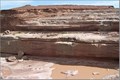
|  Sandstone Towers Sandstone Towers
in Places of Geologic Significance Two tall sandstone towers suddenly appear in the distance as you are driving along US Highway 160 in Arizona. posted by:  Miragee Miragee location: Arizona date approved: 07/09/2007 last visited: 03/25/2015 |
 view gallery view galleryNW54.7 km |  McDonalds Free WiFi ~ Tuba City McDonalds Free WiFi ~ Tuba City
in Wi-Fi Hotspots Free WiFi Served Daily at the McDonalds at 195 S Main Street in Tuba City, Arizona. posted by: brwhiz location: Arizona date approved: 06/24/2011 last visited: 11/17/2015 |
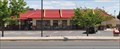 view gallery view galleryNW54.9 km |  McDonalds ~ Tuba City McDonalds ~ Tuba City
in McDonald's Restaurants This is the only McDonalds in Tuba City and for at least 50 miles in every direction. posted by: brwhiz location: Arizona date approved: 06/28/2011 last visited: 11/17/2015 |
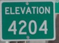 view gallery view gallery W62.9 km W62.9 km
|  Little Colorado River Bridge ~ Elevation 4204 Little Colorado River Bridge ~ Elevation 4204
in Elevation Signs The elevation of the US Highway 89 bridge across the Little Colorado River at Cameron, Arizona is 4204 feet. posted by: brwhiz location: Arizona date approved: 06/23/2011 last visited: 07/13/2017 |
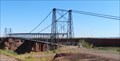
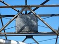 view gallery view galleryW62.9 km |  Cameron Suspension Bridge - 1911 - Cameron, AZ Cameron Suspension Bridge - 1911 - Cameron, AZ
in Bridge Date Stones and Plaques This historic, one lane, suspension bridge, now decommissioned and carrying a pipeline, is located next to US-89 and north of the Cameron Trading Post. posted by: iconions location: Arizona date approved: 10/10/2019 last visited: 08/17/2022 |
 view gallery view galleryW62.9 km |  Cameron Suspension Bridge - Cameron, AZ Cameron Suspension Bridge - Cameron, AZ
in Wikipedia Entries This historic, one lane, suspension bridge, now decommissioned and carrying a pipeline, is located next to US-89 and north of the Cameron Trading Post. posted by: iconions location: Arizona date approved: 09/12/2019 last visited: 08/17/2022 |
 view gallery view galleryW62.9 km |  Cameron Suspension Bridge - Cameron, AZ Cameron Suspension Bridge - Cameron, AZ
in U.S. National Register of Historic Places This suspension bridge was built in 1911 after danger of flooding and quicksand at Tanner's Crossing of The Mormon Trail. It was a one-lane bridge for vehicles, but now only carries an oil pipeline. posted by: DopeyDuck location: Arizona date approved: 09/30/2008 last visited: 08/17/2022 |
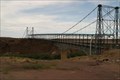
 view gallery view galleryW62.9 km |  Little Colorado River Bridge - Cameron, AZ Little Colorado River Bridge - Cameron, AZ
in Suspension Bridges This suspension bridge was built in 1911 by the Midland Bridge Co. for the Office of Indian Affairs. The one-lane bridge is closed to vehicles now, but appears to carry an oil pipeline. It is also a Natl Historic Place. posted by: DopeyDuck location: Arizona date approved: 09/29/2008 last visited: 08/17/2022 |
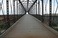 view gallery view galleryW62.9 km |  Historic Tanner's Crossing Bridge - Cameron, AZ Historic Tanner's Crossing Bridge - Cameron, AZ
in Orphaned Bridges This suspension bridge was built in 1911 by the Midland Bridge Co. for the Office of Indian Affairs. It is also a Natl Historic Place. The one-lane bridge is closed to vehicles now, but appears to carry an oil pipeline. posted by: DopeyDuck location: Arizona date approved: 09/29/2008 last visited: 08/17/2022 |
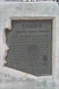 view gallery view galleryW62.9 km |  Cameron AZ Marker - Cameron, AZ Cameron AZ Marker - Cameron, AZ
in Arizona Historical Markers This marks the area of Tanner's Crossing of the Little Colorado River on the Mormon Trail. posted by: DopeyDuck location: Arizona date approved: 10/05/2008 last visited: 08/17/2022 |
 view gallery view galleryW62.9 km |  Tanner's Crossing of The Mormon Trail - Cameron, AZ Tanner's Crossing of The Mormon Trail - Cameron, AZ
in Wagon Roads and Trails This suspension bridge marks the area of Tanner's Crossing of the Little Colorado River on The Mormon Trail from Utah via Lee Ferry to settlements in Arizona and Mexico. posted by: DopeyDuck location: Arizona date approved: 09/29/2008 last visited: 08/17/2022 |
 view gallery view galleryW62.9 km |  Cameron Trading Post Gallery ~ Cameron, Arizona Cameron Trading Post Gallery ~ Cameron, Arizona
in Art Galleries The Cameron Trading Post Gallery is located in a complex on the west side of US Highway 89 on the south bank of the Little Colorado River. posted by: brwhiz location: Arizona date approved: 11/10/2012 last visited: 03/20/2019 |
 view gallery view galleryW63.1 km |  Kokopelli on Smashed Penny Kokopelli on Smashed Penny
in Kokopelli Sightings This Kokopelli is just barely visible on the second of four designs in a Penny Smasher in Cameron, Arizona. Take home your own Kokopelli and Grand Canyon Souvenir for only 51 cents! posted by: brwhiz location: Arizona date approved: 06/21/2011 last visited: 03/20/2019 |
 view gallery view galleryW63.1 km |  Cameron Trading Post Penny Smasher Cameron Trading Post Penny Smasher
in Penny Smashers This Penny Smasher is inside the Cameron Trading Post located at 466 N Highway 89 in Cameron, Arizona. posted by: brwhiz location: Arizona date approved: 06/25/2011 last visited: 03/20/2019 |
 view gallery view galleryW63.1 km | Cameron, Arizona 86020 ~ Main Post Office in U.S. Post Offices This Post Office is located at 465 US Highway 89 in Cameron, Arizona. posted by: brwhiz location: Arizona date approved: 09/05/2011 last visited: 09/11/2019 |
 view gallery view galleryW66.5 km |  High-Wire Walk across Grand Canyon High-Wire Walk across Grand Canyon
in News Article Locations Daredevil Nik Wallenda completed a historic high-wire walk over a section of the Grand Canyon on June, 23, 2013. posted by: Bernd das Brot Team location: Arizona date approved: 06/24/2013 last visited: never |
 view gallery view gallery SW66.9 km SW66.9 km
|  Grand Falls Grand Falls
in Waterfalls The Grand Falls Overlook is located at a picnic area on the Navajo Indian Reservation. The road is graded dirt and should be fine for all vehicles except for when it is wet. There is no fee, but keep the area clean and all pets must be leashed so they don’t disturb the livestock. posted by: TerryDad2 location: Arizona date approved: 07/19/2006 last visited: 11/11/2015 |
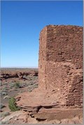 view gallery view gallerySW67.9 km |  Wukoki Pueblo Wukoki Pueblo
in New World Ancient Evidence The Wukoki Pueblo is built on an rock outcrop in the Wupatki National Monument. posted by: TerryDad2 location: Arizona date approved: 07/26/2006 last visited: 04/11/2017 |
 view gallery view gallerySW71.6 km | Wupatki Pueblo in New World Ancient Evidence The Wupatki Pueblo Ruin in the Wupatki National Monument has a number of rooms, an outdoor meeting area, and an arena. posted by: TerryDad2 location: Arizona date approved: 07/26/2006 last visited: 02/19/2022 |
 view gallery view gallerySW71.6 km |  Wupatki National Monument - Wupatki Pueblo Wupatki National Monument - Wupatki Pueblo
in National Parks of the World The Wupatki Pueblo Ruin in the Wupatki National Monument has a number of rooms, an outdoor meeting area, and an arena. posted by: TerryDad2 location: Arizona date approved: 08/24/2006 last visited: 05/24/2024 |
 view gallery view gallerySW71.6 km | Wupatki Pueblo Blowhole in Places of Geologic Significance This location is behind the Wupatki National Monument Visitor Center. A paved trail leads through the Wupatki Pueblo and down to the blowhole. Wheelchair accessable, but there are some relatively steep sections. posted by: TerryDad2 location: Arizona date approved: 01/31/2007 last visited: 02/19/2022 |
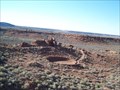 view gallery view gallerySW71.6 km | Wupatki National Monument in U.S. National Register of Historic Places The Wupatki Pueblo Ruin in the Wupatki National Monument has a number of rooms, an outdoor meeting area, and an arena. The National Monument has a number of other ruins that have developed trails and parking lots. posted by: TerryDad2 location: Arizona date approved: 07/29/2006 last visited: 02/19/2022 |
 view gallery view gallerySW71.6 km | Wupatki National Monument in Wikipedia Entries A smaller National Monument protects Native American ruins. posted by: ChapterhouseInc location: Arizona date approved: 11/20/2010 last visited: 02/19/2022 |
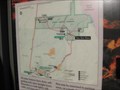 view gallery view gallerySW71.6 km |  Wupatki NM Visitor Center Map Wupatki NM Visitor Center Map
in 'You Are Here' Maps A smaller National Monument protects Native American ruins. posted by: ChapterhouseInc location: Arizona date approved: 11/20/2010 last visited: 06/13/2013 |
|