 view gallery view gallery SE14.2 km SE14.2 km
|   Daviston, Alabama - Daviston, AL Daviston, Alabama - Daviston, AL
in Alabama Historical Markers Daviston, Alabama, incorporated February 16, 1887, is believed to be the first incorporated rural town in Tallapoosa County. posted by:  hummerstation hummerstation location: Alabama date approved: 02/25/2016 last visited: never |
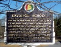 view gallery view gallerySE14.2 km | Daviston School - Daviston, AL in Alabama Historical Markers At the time of its closing in 1988 Daviston School was the smallest school in Alabama with 120 K-12 students. posted by: hummerstation location: Alabama date approved: 02/25/2016 last visited: never |
 view gallery view gallery E14.8 km E14.8 km
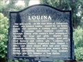
| Louina in Alabama Historical Markers On AL 22 just east of the Tallapoosa River bridge. posted by: Markerman62 location: Alabama date approved: 03/22/2015 last visited: 03/11/2015 |
 view gallery view gallery SW16.1 km SW16.1 km
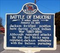
| Battle of Emucfau - New Site, AL in Alabama Historical Markers The Battle of Emucfau occurred January 22, 1814. posted by: hummerstation location: Alabama date approved: 02/25/2016 last visited: 07/27/2017 |
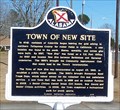 view gallery view gallerySW16.3 km | Town of New Site - New Site, AL in Alabama Historical Markers The Town of New Site was incorporated on August 23, 1965, to establish a public water system. posted by: hummerstation location: Alabama date approved: 02/25/2016 last visited: 07/27/2017 |
 view gallery view gallery NW16.4 km NW16.4 km
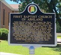
| First Baptist Church of Ashland - Ashland, AL in Alabama Historical Markers Located on 1st Ave. just north of 5th St. notes the founding of the church and its subsequent buildings used by the congregation. posted by:  hoteltwo hoteltwo location: Alabama date approved: 06/21/2016 last visited: never |
 view gallery view gallery N16.4 km N16.4 km
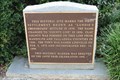
|  Site of Lundie's Crossroads -- Lineville AL Site of Lundie's Crossroads -- Lineville AL
in Signs of History This sign of history preserves the memory of Lundie's Crossroads, a precursor to modern-day Lineville AL posted by: Benchmark Blasterz location: Alabama date approved: 09/02/2017 last visited: 07/27/2017 |
 view gallery view galleryN16.4 km |  Incorporation of Lineville - 100 Years - Lineville, AL Incorporation of Lineville - 100 Years - Lineville, AL
in Commercial Commemorations This sign of history preserves the memory of Lundie's Crossroads, a precursor to modern-day Lineville AL, and celebrates Lineville's centennial of incorporation as a city posted by: Benchmark Blasterz location: Alabama date approved: 09/06/2017 last visited: 07/26/2017 |
 view gallery view galleryN16.6 km |  FIRST -- White settlers in the area, Lineville AL FIRST -- White settlers in the area, Lineville AL
in First of its Kind The first white settlers in what would become Lineville were brothers William and Thomas Lundie. posted by: Benchmark Blasterz location: Alabama date approved: 09/01/2017 last visited: 07/27/2017 |
 view gallery view galleryN16.6 km | FIRST -- Mayor of Lineville, Lineville AL in First of its Kind The first Mayor of Lineville, H. J. Willingham, was appointed in 1891. posted by: Benchmark Blasterz location: Alabama date approved: 09/01/2017 last visited: 07/27/2017 |
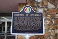
 view gallery view galleryN16.6 km | History of Lineville -- Lineville AL in Alabama Historical Markers The state historic marker in front of Lineville City Hall in Lineville AL posted by: Benchmark Blasterz location: Alabama date approved: 09/07/2017 last visited: 07/28/2017 |
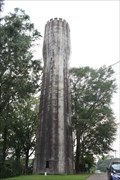 view gallery view galleryN16.7 km |  Lineville Water Tower -- Lineville AL Lineville Water Tower -- Lineville AL
in Water Towers The historic Lineville Water Tower is on the Alabama Register of Landmarks and Heritage. posted by: Benchmark Blasterz location: Alabama date approved: 09/02/2017 last visited: 07/27/2017 |
 view gallery view galleryNW16.9 km |  Clay County Courthouse - Ashland, AL Clay County Courthouse - Ashland, AL
in U.S. National Register of Historic Places Clay County Courthouse posted by: wmize location: Alabama date approved: 05/16/2011 last visited: 07/12/2012 |
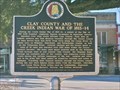
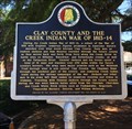 view gallery view galleryNW16.9 km | Clay County and the Creek Indian War of 1813-14 - Ashland, AL in Alabama Historical Markers Located on the grounds of the Clay County Courthouse notes the trails and areas of the future Clay County used in the Creek Indian wars of 1813-1814. posted by: hoteltwo location: Alabama date approved: 06/21/2016 last visited: never |
 view gallery view galleryNW16.9 km | Clay County and the Creek Indian Confederacy - Ashland, AL in Alabama Historical Markers Located on the lawn of the Clay County Courthouse explains the importance of Clay County area on the Creek Indian confederacy, the trails and lands used by the Creeks and the treaties involved. posted by: hoteltwo location: Alabama date approved: 06/25/2016 last visited: 01/23/2023 |
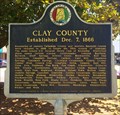 view gallery view galleryNW16.9 km | Clay County - Ashland, Alabama in Alabama Historical Markers Located on the grounds of the Clay County Courthouse near Court Square and 2nd Avenue. It describes how Clay County was formed and its historical place names within the county. posted by: hoteltwo location: Alabama date approved: 06/25/2016 last visited: never |
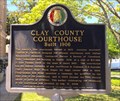 view gallery view galleryNW16.9 km | Clay County Courthouse - Ashland, AL in Alabama Historical Markers Marker located on the grounds of the Clay County courthouse at Court Square notes the history of the courthouse and famous county politicians. posted by: hoteltwo location: Alabama date approved: 06/25/2016 last visited: never |
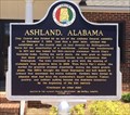 view gallery view galleryNW16.9 km | Ashland, Alabama in Alabama Historical Markers Marker located in front of the Ashland City Hall notes the early and current history of the city. posted by: hoteltwo location: Alabama date approved: 06/25/2016 last visited: never |
 view gallery view gallery S20.8 km S20.8 km
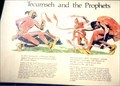
| Tecumseh and the Prophets - Daviston AL in Signs of History In 1811 Tecumseh, a Shawnee Indian tapped the growing resentment within the Creek Nation. posted by: Don.Morfe location: Alabama date approved: 11/07/2020 last visited: 09/24/2021 |
 view gallery view galleryS20.9 km | ") Horseshoe Bend NMP Horseshoe Bend NMP
in National Parks (U.S.) In the spring of 1814, General Andrew Jackson and an army of 3,300 men attacked 1,000 Upper Creek warriors on the Tallapoosa River. Over 800 Upper Creeks died defending their homeland. Never before or since in the history of our country have so many American Indians lost their lives in a single battle. This 2040-acre park preserves the site of the battle.
posted by: tiki-4 location: Alabama date approved: 08/18/2007 last visited: 02/09/2022 |
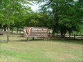 view gallery view galleryS20.9 km |  Horseshoe Bend NMP Horseshoe Bend NMP
in NPS Passport Cancellation Stations In the spring of 1814, General Andrew Jackson and an army of 3,300 men attacked 1,000 Upper Creek warriors on the Tallapoosa River. Over 800 Upper Creeks died defending their homeland. Never before or since in the history of our country have so many American Indians lost their lives in a single battle. This 2040-acre park preserves the site of the battle.
posted by: tiki-4 location: Alabama date approved: 08/19/2007 last visited: 12/07/2021 |
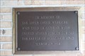
 view gallery view galleryS20.9 km |  Soldiers and Indian Allies Who Died with Upper Creeks -- Horseshoe Bend NMP, Daviston AL Soldiers and Indian Allies Who Died with Upper Creeks -- Horseshoe Bend NMP, Daviston AL
in Non-Specific Veteran Memorials A small memorial plaque at the entrance to the Visitor Center at Horseshoe Bend National Military Park honors US Soldiers and other Indian allies who died in the Creek War posted by: Benchmark Blasterz location: Alabama date approved: 09/05/2017 last visited: 07/26/2017 |
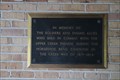
 view gallery view galleryS20.9 km |  Creek Indian War Memorial -- Horseshoe Bend NMP, Daviston AL USA Creek Indian War Memorial -- Horseshoe Bend NMP, Daviston AL USA
in Specific Wars Monuments and Memorials A plaque at the entrance to the Visitor Center at Horseshoe Bend National Military Park honors Creek warriors, US Soldiers, and their Indian allies who died in the Creek War of 1813-14 posted by: Benchmark Blasterz location: Alabama date approved: 09/04/2017 last visited: 07/26/2017 |
 view gallery view galleryS20.9 km |  Horseshoe Bend Cannon - Horseshoe Bend State Park, AL Horseshoe Bend Cannon - Horseshoe Bend State Park, AL
in Static Artillery Displays These cannons were used to bombard a Native American village in 1814 by General Andrew Jackson posted by: riston2 location: none listed yet date approved: 05/20/2010 last visited: 03/01/2019 |
 view gallery view galleryS20.9 km | Creek Warriors Who Died in Battle at Horseshoe Bend -- Horseshoe Bend NMP, Daviston AL in Non-Specific Veteran Memorials A small memorial plaque at the entrance to the Visitor Center at Horseshoe Bend National Military Park honors Creek warriors who died in the battle of Horseshoe Bend, near Daviston AL in 1814 posted by: Benchmark Blasterz location: Alabama date approved: 09/05/2017 last visited: 07/26/2017 |
|