 view gallery view gallery NE12.9 km NE12.9 km
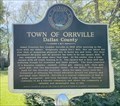
|   Town of Orrville, Alabama Town of Orrville, Alabama
in Alabama Historical Markers Located at the Town Hall in Orrville, the marker describes the settlement of the town and its later growth and industries. posted by:  hoteltwo hoteltwo location: Alabama date approved: 04/28/2024 last visited: never |
 view gallery view gallery W17.7 km W17.7 km
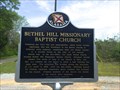
| Bethel Hill Missionary Baptist Church - McKinley, AL in Alabama Historical Markers Located on County Road 38 near Catherine, AL this marker describes the beginnings and history of the Bethel Hill Missionary Baptist Church and cemetery. posted by: hoteltwo location: Alabama date approved: 04/14/2014 last visited: never |
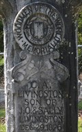 view gallery view galleryW18 km |  C.A. Livingston - McKinley Cemetery - McKinley, AL C.A. Livingston - McKinley Cemetery - McKinley, AL
in Woodmen of the World Grave Markers/Monuments Located on Bee Lane, in the former 2nd largest city in Marengo County, this is the standard WOW treestone. posted by: hoteltwo location: Alabama date approved: 04/13/2014 last visited: never |
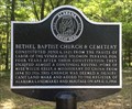 view gallery view galleryW18.2 km | Bethel Baptist Church & Cemetery - McKinley, AL in Alabama Historical Markers Small marker notes the beginnings of the church, its pastor and its addition as an Alabama Landmark. posted by: hoteltwo location: Alabama date approved: 04/14/2014 last visited: never |
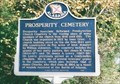 view gallery view galleryNE23.3 km | Prosperity Cemetery - near Marion Junction, AL in Alabama Historical Markers Older cemetery, in rural Dallas County on CR189 west of CR45 about 5 miles south of Marion Junction. Has some Confederate graves. Former church location. The marker has gone missing. posted by: hoteltwo location: Alabama date approved: 01/06/2018 last visited: never |
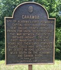 view gallery view galleryNE23.8 km |  Cahawba - Marion Junction, AL Cahawba - Marion Junction, AL
in Signs of History Marker at the crossroads of State Route 22 and Dallas County Road 9, describes the nearby old Cahaba settlement. posted by: hoteltwo location: Alabama date approved: 08/20/2014 last visited: never |
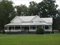
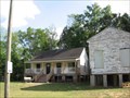
 view gallery view galleryW24.3 km |  Farrish, Patrick, House - Thomaston, Alabama Farrish, Patrick, House - Thomaston, Alabama
in U.S. National Register of Historic Places Historic home in the small community of Thomaston, Alabama. posted by:  BruceS BruceS location: Alabama date approved: 11/07/2009 last visited: never |
 view gallery view gallery N24.5 km N24.5 km
|  Target - Prattville, AL Target - Prattville, AL
in Target Stores One of the newest Targets around! posted by:  Lazer Lazer location: Alabama date approved: 10/15/2007 last visited: 11/07/2011 |
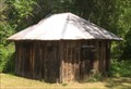 view gallery view galleryW24.8 km |  Calaboose - Thomaston, AL Calaboose - Thomaston, AL
in Retired Prisons Built sometime between 1905 to 1925, this one-room rural "jail" was used as a holding cell and is no longer in use. posted by: hoteltwo location: Alabama date approved: 04/16/2014 last visited: never |
 view gallery view galleryW24.9 km | Golden, C.S., House - Thomaston, Alabama in U.S. National Register of Historic Places Historic house in the small community of Thomaston, Alabama. posted by: BruceS location: Alabama date approved: 11/07/2009 last visited: never |
| view gallery W24.9 km |  C.S. Golden House - Thomaston, Alabama C.S. Golden House - Thomaston, Alabama
in Victorian Style Architecture Historic Victorian style house in the small community of Thomaston, Alabama. posted by: BruceS location: Alabama date approved: 11/07/2009 last visited: never |
 view gallery view galleryW24.9 km |  Thomaston, AL 36783 Thomaston, AL 36783
in U.S. Post Offices Located in rural Marengo County and home to the Pepper Jelly Festival this town has a fairly small population located at the intersection of County Roads 25 and 28. posted by: hoteltwo location: Alabama date approved: 04/20/2014 last visited: never |
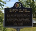 view gallery view galleryW25.1 km | History of the Town of Thomaston - Thomaston, AL in Alabama Historical Markers Located at Thomaston Town Pond, this marker notes the beginnings and history of the town of Thomaston, Alabama. posted by: hoteltwo location: Alabama date approved: 04/14/2014 last visited: never |
 view gallery view gallery E25.3 km E25.3 km
| Lafayette's Tour - Cahaba, AL in Alabama Historical Markers Located within the Old Cahawba Archaeological Park, marker describes the Marquis de Lafayette, the last surviving French general of the American Revolutionary War, made a tour of the 24 states in the United States. posted by: hoteltwo location: Alabama date approved: 04/28/2024 last visited: never |
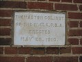 view gallery view galleryW25.6 km |  1910 - Thomaston Colored Institute - Thomaston, Alabama 1910 - Thomaston Colored Institute - Thomaston, Alabama
in Dated Buildings and Cornerstones Historic African-American school in Thomaston, Alabama. posted by: BruceS location: Alabama date approved: 11/06/2009 last visited: never |
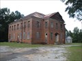 view gallery view galleryW25.6 km |  Thomaston Colored Institute - Thomaston, Alabama Thomaston Colored Institute - Thomaston, Alabama
in Former Schools Historic African-American school in Thomaston, Alabama. posted by: BruceS location: Alabama date approved: 11/07/2009 last visited: never |
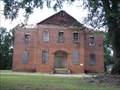 view gallery view galleryW25.6 km | Thomaston Colored Institute - Thomaston, Alabama in U.S. National Register of Historic Places Historic African-American school in Thomaston, Alabama. posted by: BruceS location: Alabama date approved: 11/07/2009 last visited: never |
| view gallery W25.6 km |  Thomaston Colored Institute - Thomaston, Alabama Thomaston Colored Institute - Thomaston, Alabama
in Wikipedia Entries Historic African-American school in Thomaston, Alabama. posted by: BruceS location: Alabama date approved: 11/07/2009 last visited: never |
 view gallery view galleryE25.7 km | Cahaba, Alabama in Wikipedia Entries In 1818, the Alabama Territorial Legislature designated the area where the Cahaba River met the Alabama River as the location for the first capital of the state. posted by: xptwo location: Alabama date approved: 04/22/2012 last visited: never |
 view gallery view galleryE25.7 km |  Old Cahawba Archaelogical Park Old Cahawba Archaelogical Park
in Civil War Discovery Trail Sites Once the site of the first capital of Alabama, Cahawba became deserted in the years after the Civil War. The Alabama Historical Commission has been buying property to allow people to learn about this once prosperous community. posted by: xptwo location: Alabama date approved: 04/18/2012 last visited: never |
 view gallery view galleryE25.7 km |  Cahawba, Alabama Cahawba, Alabama
in Ghost Towns Once the site of the first capital of Alabama, Cahawba became deserted in the years after the Civil War. The Alabama Historical Commission has been buying property to allow people to learn about this once prosperous community. posted by: xptwo location: Alabama date approved: 04/19/2012 last visited: never |
 view gallery view galleryE25.7 km | Cahaba - Selma, Alabama in U.S. National Register of Historic Places Once the site of the first capital of Alabama, Cahawba became deserted in the years after the Civil War. The Alabama Historical Commission has been buying property to allow people to learn about this once prosperous community. posted by: xptwo location: Alabama date approved: 04/23/2012 last visited: never |
 view gallery view galleryE25.7 km |  Pegue's Ghost - Old Cahawba Archaeological Park, Alabama Pegue's Ghost - Old Cahawba Archaeological Park, Alabama
in Ghosts and Hauntings Even though the State of Alabama's first capital became a ghost town, the story of its first ghost lives on. posted by: xptwo location: Alabama date approved: 04/24/2012 last visited: never |
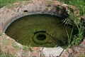 view gallery view galleryE25.9 km |  Perine Well Perine Well
in Artesian Well Marker is in Cahaba, Alabama, in Dallas County. Marker is on 6th South Street.The marker is located at the end of 6th South Street. Go south on Oak Street, 6th South Street is the second dirt road on the left from Capitol Avenue posted by: Theblackroseact location: Alabama date approved: 06/21/2010 last visited: 08/25/2010 |
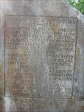 view gallery view galleryE26.4 km | Cahaba Memorial Stone - Old Cahawba Archaeological Park, Alabama in Signs of History This stone monument was erected in what was by then the mostly deserted location of the state of Alabama's first capital. posted by: xptwo location: Alabama date approved: 04/23/2012 last visited: never |
|