
Municipal Park - Comanche, OK
Posted by:  hamquilter
N 34° 21.657 W 097° 57.918
14S E 595148 N 3802663
The WPA crews developed this park in Comanche, which is still actively used today.
Waymark Code: WMYMBT
Location: Oklahoma, United States
Date Posted: 06/28/2018
Views: 0
The Comanche municipal park is located south of Willow Avenue, between Highway 81, and Old Highway 81. This is a long, narrow grass area primarily serving as a picnic and playground area.
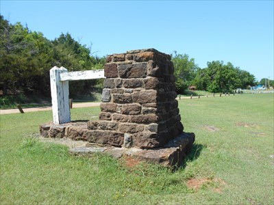
The coordinates above are located at an original WPA-constructed rock sign near the north of the park on Old Highway 81. This is a native sandstone pillar with heavy wood posts to the side which once held a sign.
There are quite a few picnic tables which were built in the mid-1930's by the WPA. They have brick support posts and concrete table tops and benches. Some are in poor condition, and some others have had their concrete tops replaced. The Oklahoma Historical Society database shows that this project had an appropriation of $6800 and was completed in November 1935.