|
 Boley, Oklahoma Posted by:  hamquilter hamquilter
N 35° 29.291 W 096° 29.052
14S E 728223 N 3930092
This historical marker stands on Highway 62, at the intersection with S. Pecan Street.
Waymark Code: WMYBQP
Location: Oklahoma, United States
Date Posted: 05/26/2018
Views: 3
This is an Oklahoma Historical Society marker on the south side of the town of Boley. The marker describes the establishment of the all-black town. The town currently has a population of about 1180 residents.
BOLEY, OKLAHOMA
Est. August 1903 - Inc. May 11, 1905
Boley, Creek Nation, I.T., established
as all Black town on land of Creek
Indian "Freedwoman" Abigail Barnett.
Organized by T.M. Haynes first town-
site manager. Named for J. B. Boley,
white roadmaster, who convinced Fort
Smith and Western Railroad that blacks
could govern themselves. This concept
soon boosted population to 4,200.
Declared National Historic Landmark
District by act of Congress 5-15-75.
Oklahoma Historical Society 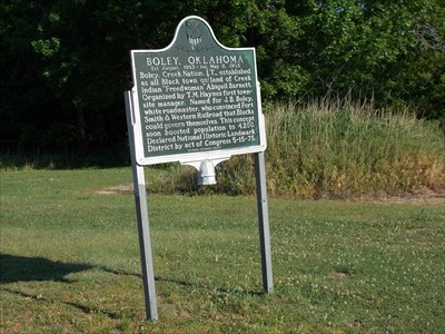
|
County: Okfuskee County

Record Address::
Highway 62 at S. Pecan Street
Boley, OK US
74829
Web site if available: [Web Link]
Rate the Site: 
Sponsor (Who put it there): Oklahoma Historical Society
Date Erected: Not listed
|
Visit Instructions:1 - Must visit the site in person.
2 - New Photo required.
3 - Give some new insight to the marker/site.
|