"Downtown" Jamul USGS Benchmark
Posted by: Groundspeak Regular Member Miragee
N 32° 42.847 W 116° 52.571
11S E 511603 N 3619601
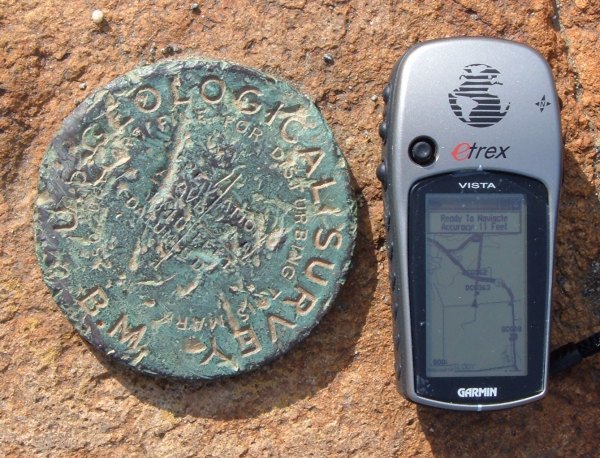
Near the intersection of Maxfield Road and Proctor Valley Road in Jamul there is a boulder with a Benchmark Disk embedded in it.
Waymark Code: WMMJC
Location: California, United States
Date Posted: 08/18/2006
Published By:Groundspeak Regular Member Black Dog Trackers
Views: 53

Along the road in the small downtown area of Jamul is a boulder with this benchmark disk embedded in it. Because of its condition, it looks like the boulder was tumbled around by a bulldozer when it was disturbed from its original location by construction.

To get to the benchmark, from Highway 94, take Proctor Valley Road south at the stoplight in Jamul. Turn east on Maxfield. Traveling west on Highway 94, turn left on Maxfield Road where the post office is. The boulder is on the north side of Maxfielf Road.

Condition: Mark found in poor condition

Designation: -blank-

Benchmark Agency: U.S. Geological Survey

Monumentation type: Disk (unspecified type)

County: San Diego

Special category (optional): Not listed

Find type: Found by luck/skill/knowledge

Benchmark Agency (if other): Not listed

Monumentation type (if other): Not listed

USGS 7.5' Topographic Quadrangle Name (optional): Not listed

Special Category (if other): Not listed

Web address of this benchmark's datasheet (optional): Not listed

NGS PID: Not listed

Local database's URL (optional): Not listed

Visit Instructions:
  1. A closeup photo of the mark taken by you is required.
  2. A 'distant' photo including the mark in the view is highly recommended. Include the compass direction you faced when you took the picture.
Search for...
Geocaching.com Google Map
Google Maps
MapQuest
Bing Maps
Nearest Waymarks
Nearest U.S. Benchmarks
Nearest Geocaches
Create a scavenger hunt using this waymark as the center point
Recent Visits/Logs:
There are no logs for this waymark yet.