
Pinetown Bushong's Mill Covered Bridge - Manheim, PA
N 40° 06.342 W 076° 14.897
18T E 393609 N 4440235
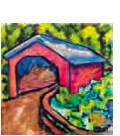
The bridge has a single span, wooden, double Burr arch trusses design with the addition of steel hanger rods. The deck is made from oak planks. It is painted red, the traditional color of Lancaster County covered bridges, on both the inside and out.
Waymark Code: WMJ04Y
Location: Pennsylvania, United States
Date Posted: 09/03/2013
Views: 3
The Pinetown Covered Bridge has carried traffic across the Conestoga River for nearly a century and a half. But the wooden structure has sat idle and barricaded since flooding caused by the remnants of Tropical Storm Lee closed it with a rude shove downstream in September 2011. The force of the water shifted the bridge on its foundation and skewed its rectangular openings into parallelograms. Now, with funding and permits finally in hand, the county has the 1867 bridge on the fast track back to service connecting Manheim and Upper Leacock townships. It is expected to reopen by late summer.
Another typical Lancaster County bridge built in the later half of the 19th century. The bridge spans the Conestoga River in Lancaster County, PA, U.S. A county-owned and maintained bridge, its official designation is the Big Conestoga #6 Bridge.
It was hard to get good pictures as it is a single lane, & not much parking except in a cornfield and inside the bridge, there is no pedestrian walkways. The bridge was built in 1867 by Elias McMellen at a cost of $4,500. In 1972 it was destroyed as a result of flooding caused by Hurricane Agnes. Due to a tremendous response of area residents who signed a petition for its reconstruction, it was among the first covered bridges to be restored after Agnes. In the spring of 1973, the bridge was rebuilt by the nearby Amish. To prevent damage due to future flooding, they raised the bridge to 17.5 feet (5.3 m) above the average water line. Added in 1980, it is listed on the National Register of Historic Places as structure number 80003527.
The bridge is reputed to be haunted by a young Amish girl. Boo!