
Lost City of Tryon - Penfield, NY
Posted by:  sagefemme
N 43° 10.007 W 077° 31.547
18T E 294681 N 4782432
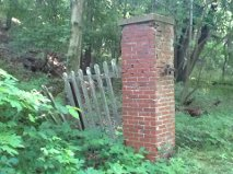
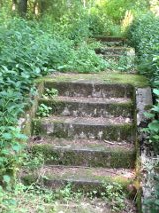
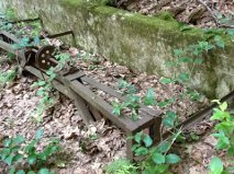
The remains include a pair of brick gate posts, several sets of concrete steps leading to nowhere, an early sewer drain system, and a concrete structure of unknown purpose. The American Guide Series (published 1937) names it the Lost City of Tryon.
Waymark Code: WMENN0
Location: New York, United States
Date Posted: 06/19/2012
Views: 14
The Lost City of Tryon is now part of the Lucien Moran County Park, which was also known as the Ellison Park Wetlands. While Ellison Park (proper) is in the town of Brighton, this portion of the park is in Penfield, and best accessed from Empire Boulevard. The park now known as Tryon Park occupies much steaper ground on the west side of Irondequoit Creek.
I've visited this park many times. I've seen these remains in bits and peices, over time and often wondered about it. When I discovered waymarking, and some of the interesting categories (including American Guide Series category) I was delighted to put this all together as a story!
The American Guide Series has a description of the "Lost City of Tryon" in the section entitled "Rochester Anecdotes" (starts at page 73). The portion partaining to settlement by descendants of European immigrants starts on page 99:
Then, for a few years, quiet prevailed, broken only by the passage of Indian hunters, or, at rare intervals, of a white man. Each newcomer attracted others, and by 1797 a small settlement had found foothold at the Landing. Eight years later, taking its name from an early settler, Tryon stood against its background of wilderness, a bustling "city." It possessed a store serving the area of the three counties of Livingston, Ontario, Erie, a warehouse, a blacksmith shop, a shoe factory, a tavern, and even a school. A distillery and a tannery exported their products to Canada; and in Tryon's large flour mill the stones, taken from "Indian" Allen's abandoned mill at The Falls, ground large quantities of flour to be sent to Montreal. A flourishing shipyard launched its ships on Irondequoit Creek. All this before Rochesterville had emerged from the Genesee swamplands.
Then Tryon's sudden glory began to fade. New mills at The Falls drew industry that way, and Tryon's sun went down. The pounding hammers of its shipbuilders were stilled, its mills were idle. Deserted, abandoned, its buildings crumbled to ruin, the last trace of the ghost town passed away, save for a lingering hint of its dreams of
splendor in the melancholy name of "the lost city of Tryon.
Another source (a local historian's website) http://www.vintageviews.org/vvtl/timeline/settlers.html tells us that Salmon Tryon purchased 420 acres from John Lusk for £200. The same source goes on to say "John Tryon buys land from Salmon Tryon (they may be brothers, or not related, records are not clear) for £400. Tryon City founded near Indian Landing on an ancient Indian trail, in present Ellison Park. A store, blacksmith's shop, shoe factory, distillery, tavern, tannery, large gristmill, shipyard, school, and a five story log warehouse are all built. Augustus Griswold brings five sleigh loads of merchandise. But trade was all going through the Upper Falls area, and Tryon never grew. Site was abandoned in 1818." This source doesn't mention Tryon again, but the date of abandonment given, by coincidence is the year Col. Natanial Rochester moved to Rochesterville from Dansville.
The parking coordinates are "a sure thing". The recommended access coordinates below also has space for one or two cars, but the gate at the upper parking lot may prohibit you from driving all the way to the access coordinates.
The trail from the access coordinates will take you past the "ancient gate posts. If you continue straight and to the right (south and west) you will find one set of concrete steps that lead to a relatively new gazebo. If you take the first trail intersection to your left (east) you will come across a cluster of concrete steps leading to level ground where some buildings once stood. You may also see the remains of a human made water system (manhole covers). The primary coordinates posted above will take you to a concrete structure of unknown (to me) purpose. If you can identify that purpose, please do so in your visit log!