
This Battery was part of Alexander’s Battalion which served as a member of the Artillery Reserve in the First Corps, Army of Northern Virginia. The Battalion commander, Colonel Edward Porter Alexander (1827-1911) (May 26, 1835 – April 28, 1910), was an engineer, an officer in the U.S. Army, a Confederate general in the American Civil War, and later a railroad executive, planter, and author.
This battery (the subject of this waymark) however, was commanded by Osmond B. Taylor (KIA April 6, 1865). Taylor commanded the Eubanks-Taylor battery (also called Bath Artillery per Crute) assigned to Longstreet's Corps, Army of Northern Virginia. He was promoted to lieutenant in March 1862 upon the organization of the Bath Artillery that was for a short time assigned to the 12th Virginia Battalion. His battery @ Gettysburg lost 15% of those engaged. Taylor had been promoted to Captain in March 1863 and commanded the battery during the advance into Pennsylvania. The battery formed part of the Petersburg defenses with the remnants surrendering at Appomattox. Captain Taylor was killed at Richmond on April 6, 1865, shot dead when he refused to surrender.
The Taylor Tablet is on the left or east side of West Confederate Avenue if traveling south, exactly 100 feet south of the Millerstown Road, 4-way intersection. The Longstreet Corps Tablet is direclty across the road. 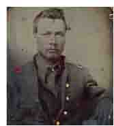 The Confederate Avenue Observation Tower and parking lot is 450 feet south of this position. The lot is good for 15 cars. If you want to park at the tablet, there is intermittent cutouts along the road to pull over. Avoid parking on anything green or you will be ticketed by the park police. They almost got me. I visited this monument on Saturday, March 10, 2012 at 3:54 PM, just before the clocks were set ahead for the Spring. I was at a 600 foot ASL elevation.
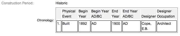
These monuments were first built in 1900 and concluded in 1906 according to the NRHP nomination form. Some sites have the monuments being erected in 1910 or later; the NRHP also has this specific one at 1892 ending in 1900 so it would seem the current NPS is clueless about the installation date. 1910 seems to be the most reasonable date so we will go with that. It is amazing with all the work and effort exerted to make the Gettysburg National Military Park a reality, no one took the time to keep accurate records and correct installation dates. The work was done under the direction of the Gettysburg National Park Commission (established by the United States Department of War), after they took over the administration of the park from the Gettysburg Battlefield Memorial Association (whose funds had expired) on March 3, 1893, and whose stewardship was then transferred to the National Park Service in 1933 SOURCE.
Draw the Sword, with descriptive help from the NPS site, offers the following description: Cast iron tablet, 3’8" x 3’4", with raised inscription painted in a contrasting color and mounted on fluted cast iron post. All 4’4" H. Tablets casts by Calvin Gilbert. The inscription on the 3.8' x 3.4' tablet narrates the events associated with Battery during the Battle. The battery's position early in the afternoon of July 2 and on July 5 is represented by two Confederate 12-pounder Napoleon guns cast at the Augusta Foundry, in Georgia. The cannons flank the marker. The inscription on the tablet reads:
Army of Northern Virginia
Longstreet's Corps Artillery Reserve
Alexander's Battalion Taylor's Battery
Four Napoleons
July 2 Took position here 4 p.m. and opened fire on Peach Orchard. Advanced at 5 p.m. with the infantry to a position about 400 feet north of Peach Orchard and east of Emmitsburg Road continuing actively engaged until night.
July 3 Took position 3 a.m. in main artillery line near Smith House northeast of Sherfy House on Emmitsburg Road and held it all day. Took part in cannonade preceding Longstreet's final assault supported that assault and aided in repelling sharpshooters afterwards. Retired from the front after night.
July 4 In position near here until 4 p.m. Then withdrew to Marsh Creek on Fairfield Road.
Losses killed 2 wounded 10.
There are scores of similar monuments for the various Confederate States & Union units which fought at Gettysburg. Four designs represent brigade, division, corps and army headquarters, and each has elements which identify it as Union or Confederate. Many of the tablets were created by Albert Russell & Sons Co. of Newburyport, Massachusetts and are made of granite, bronze and concrete or like this one, cast iron. All of these tablets were designed by architect Colonel Emmor Bradley Cope (July 23, 1834 - May 28, 1927). He designed pretty much every tablet for both the Union and Confederate armies, each one distinct, with several different varieties. He is buried in Evergreen Cemetery in Gettysburg, as well as he should be as this park and most of the things seen here today were designed by him and as such, are his legacy. These monuments/tablets were erected just after the turn of the century during the first and beginning of the second decade of the 20th century. Each one has since been preserved or restored at least twice since the turn of the 21st century. The plaques and tablets were erected by the Gettysburg Park Commission (established by the War Department). The Gettysburg Park Commission is also referred to as the Gettysburg National Military Park Commission or the Gettysburg National Park Commission, to clear up any confusions, especially my own.
On October 1, 1898, the Gettysburg National Park Commission in a letter to the Secretary of War set gave recommendations for continuing the task of organizing and progressing the work of the Gettysburg National Military Park. Every November they wrote their annual report which outlined the work of the GNPC for that year. The following is an excerpt from that report relevant to this waymark. The link at the end of the paragraph will take you to the entire report. The method of marking the positions of troops on this field, as approved by the War Department, is to place the principal tablet or monument of each command at the position occupied by the command in the main line of battle, and to mark the several important positions subsequently reached by each command in the course of the battle by subordinate and ancillary tablets, with appropriate brief inscriptions giving interesting details and occurrences and noting the day and hour as nearly as possible. SOURCE
Most of the Commission reports have been digitized and can be found HERE. The initial 1893 report up to and including 1921 can be found here. 1922 to 1926 are missing and have yet to be discovered. The years 1927 to 1933 were discovered in 1996 and are also included. To my knowledge this is the most comprehensive list of documents that illustrated the development and formation of the park.
Information about these specific types of monuments:
CONFEDERATE BATTERY AND BRIGADE TABLETS (ADVANCED POSITION)
These tablets are 3’8" x 3’4" in dimensions, with carefully prepared inscriptions cast in raised letters painted in white (contrasting the black background) describing the part taken in the battle by each brigade, their position and stating its numbers and losses so far as practicable to obtain. They are mounted on iron pillars or fluted cast iron posts about 3 feet high, grouted in the ground, and the tablets are inclined at a suitable angle so that the inscriptions can easily be read by persons riding or driving on the avenue. Every tablet is 4’4" in height. The advance position markers were cast by Calvin Gilbert. SOURCE & SOURCE
The Taylor's Virginia Battery Tablet is a contributing feature to the Gettysburg National Military Park Historic District which is nationally significant under NR Criteria A, B, C & D. Areas of Significance: Military, Politics/Government, Landscape Architecture, Conservation, Archeology-Historic. Period of Significance: 1863-1938. The original National Register Nomination was approved by the Keeper March 19, 1975. An update to this nomination was approved by the Keeper on January 23, 2004. The monument is identified as structure number MN566-B.
From the Nomination Form:
One of 100 cast iron tablets designed by E.B. Cope marking positions of batteries and brigades along avenue system not otherwise marked by monumentation. Tablets designating artillery positions have 1-4 mounted cannons flanking them. Marks the position of Taylor's CS Battery during July 2-4, 1863.
Short Physical Description:
Cast iron tablet w/ raised inscription painted in contrasting color & mounted on fluted cast iron post. 4'4" high; 3.8' x 3.4' tablet, inscription narrates events associated w/ Battery @ Battle. Two cannons flank tablet. Located E side of Confederate Ave. S of Millerstown Rd near observation tower.
Long Physical Description:
Cast iron tablet with raised inscription painted in a contrasting color and mounted on fluted cast iron post. 4'4" high. The 3.8' x 3.4' tablet was cast by Calvin Gilbert, and the inscription narrates the events associated with Battery during the Battle. Two cannons flank the tablet (one on each side). Located on the east side of West Confederate Avenue, south of Millerstown Road near observation tower.
My Sources
1.
NRHP Nomination Form
2.
Stone Sentinels
3.
Virtual Gettysburg
4.
Draw the Sword
5.
Historical Marker Database
6.
Cowan's Auctions
7.
Civil War Reference