
Semmes’ Brigade served as a member of McLaws’ Division in the First Corps, Army of Northern Virginia. The unit was commanded by Brig. Gen. Paul Jones Semmes (June 4, 1815 – July 10, 1863) who was a banker, businessman, and a Confederate general in the American Civil War. Semmes was mortally wounded in the thigh while leading a charge across the Wheatfield at the Battle of Gettysburg on July 2, 1863. He died eight days later in Martinsburg, West Virginia, and was buried in Linwood Cemetery in Columbus. Shortly before his death, Semmes told a war correspondent, "I consider it a privilege to die for my country."
The Semmes' Brigade - CS Brigade Tablet is located West Confederate Avenue, on the right or west side of traveling west. To the rear or north of this position is the Confederate Avenue Observation Tower as well as the parking lot. The monument faces the east. 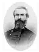 For this monument, park at the observation tower lot. Parking can also be had at the side of the road at small, intermittently placed cutouts. Please do not park on the grass, park on the side of the road. I cannot emphasize that enough! You will be ticketed. I visited this monument on Saturday, March 10, 2012 at 4:06 PM, just before the clocks were set ahead for the Spring. I was at a 593 foot ASL elevation.
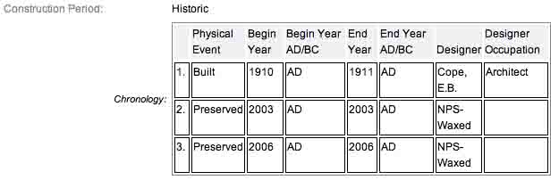
Draw the Sword reports the last of these monuments were completed on December 19, 1910. For some reason, the actual dates on when these things were installed are always murky. It is amazing with all the work and effort exerted to make the Gettysburg National Military Park a reality, no one took the time to keep accurate records and correct installation dates. The work was done under the direction of the Gettysburg National Park Commission (established by the United States Department of War), after they took over the administration of the park from the Gettysburg Battlefield Memorial Association (whose funds had expired) on March 3, 1893, and whose stewardship was then transferred to the National Park Service in 1933) SOURCE.
Draw the Sword, with descriptive help from the NPS site, offers the following description: Monolith consisting of polished smooth red Maine granite pedestal with a circular base. On each pedestal is mounted a bronze inscription tablet describing the movements and actions of the unit. The base is 3.8 feet x 3.4 feet in diameter with a height of 5’4". The tablet measures 4 feet by 3 feet 8 inches and weighs 300 pounds with the overall weight at 3000 pounds. The tablet was constructed by Albert Russell & Sons Co. of Newburyport, Massachusetts and erected by the United States War Department. The last part is sort of correct, the Gettysburg Military Park Commission, created by the War Department actually had their workers install the monuments.
One of 64 Confederate brigade monuments. Designed by E. B. Cope and erected by the U.S. War Department. They indicate the general location of the centers of the various Confederate brigades and artillery battalions during several phases of the battle. Some of the tablets were made from melted down Civil War cannon. The tablets describe the itinerary and movements of each brigade. Erected circa 1910. The last monument was completed on December 19, 1910. The inscription on this tablet reads:
 C.S.A.
Army of Northern Virginia
Longstreet's Corps McLaws's Division
Semmes's Brigade
10th. 50th. 51st. 53rd. Georgia Infantry
July 2 Arrived about 3.30 p.m. and formed line 50 yards west of this. Advanced about 5 p.m. in support of Kershaw and Anderson and took a prominent part in the severe and protracted conflict on Rose Hill and in the ravine and forest east of there and in the vicinity of the Loop. Participated also in the general advanced late in the evening by which the Union forces were forced out of the Wheatfield and across Plum Run Valley. Brig.-Gen. Paul J. Semmes fell mortally wounded in the ravine near the loop.
July 3 During the forenoon Anderson's Brigade being withdrawn for duty elsewhere the Brigade was left in occupancy of the woodland south of the Wheatfield. At 1 p.m. under orders it resumed its original position near here.
July 4 About midnight began the march to Hagerstown, Md.
Present about 1200. Losses 430.
There are scores of similar monuments for the various Confederate States & Union units which fought at Gettysburg. Four designs represent brigade, division, corps and army headquarters, and each has elements which identify it as Union or Confederate. Many of the tablets were created by Albert Russell & Sons Co. of Newburyport, Massachusetts and are made of granite, bronze and concrete or like this one, cast iron. All of these tablets were designed by architect Colonel Emmor Bradley Cope (July 23, 1834 - May 28, 1927). He designed pretty much every tablet for both the Union and Confederate armies, each one distinct, with several different varieties. He is buried in Evergreen Cemetery in Gettysburg, as well as he should be as this park and most of the things seen here today were designed by him and as such, are his legacy. These monuments/tablets were erected just after the turn of the century during the first and beginning of the second decade of the 20th century. Each one has since been preserved or restored at least twice since the turn of the 21st century. The plaques and tablets were erected by the Gettysburg Park Commission (established by the War Department). The Gettysburg Park Commission is also referred to as the Gettysburg National Military Park Commission or the Gettysburg National Park Commission, to clear up any confusions, especially my own.
On October 1, 1898, the Gettysburg National Park Commission in a letter to the Secretary of War set gave recommendations for continuing the task of organizing and progressing the work of the Gettysburg National Military Park. Every November they wrote their annual report which outlined the work of the GNPC for that year. The following is an excerpt from that report relevant to this waymark. The link at the end of the paragraph will take you to the entire report. The method of marking the positions of troops on this field, as approved by the War Department, is to place the principal tablet or monument of each command at the position occupied by the command in the main line of battle, and to mark the several important positions subsequently reached by each command in the course of the battle by subordinate and ancillary tablets, with appropriate brief inscriptions giving interesting details and occurrences and noting the day and hour as nearly as possible. SOURCE
Information about these specific types of monuments:
BRIGADE HEADQUARTERS MARKERS (FOR UNION & CONFEDERATE TABLETS)
Brigade Headquarters (and Confederate artillery battalions, equivalent to Union artillery brigades) are bronze tablets mounted at an angle on a stone pedestal. They are the most numerous headquarters at Gettysburg, with over 70 Union and over 60 Confederate examples on the field. Union headquarters are marked with their corps or service branch symbol (like a cross, clover or crescent moon), while Confederate headquarters are simply labeled "C.S.A.". There are seventy-four brigade markers at Gettysburg honoring the AOP’s various brigades. (Other sources say there are 75). They were built by Albert Russell & Sons Co. of Newburyport, Massachusetts and Charles Kappes. The pedestals consist of sea-green granite with a square 36” x 36” base; they weigh 3500 pounds. On each pedestal is mounted a bronze tablet with rounded corners weighing 300 pounds. There are sixty-four brigade markers honoring the Army of North Virginia's various brigades. They were built by Van Amringe Granite Company (pedestals), Albert Russell & Sons Co., Newburyport, Mass (tablets) and Charles Kappes (foundations). The last was completed in December 1910. The 1910 date is disputed by other sites listing the end dates as 1912. The monuments consist of red circular Maine granite bases 34 1/2 inches diameter and weighing 3,000 pounds. On each base is mounted a 300 pound bronze tablet. SOURCE & SOURCE
The Semmes' Brigade - CS Brigade Tablet is a contributing feature to the Gettysburg National Military Park Historic District which is nationally significant under NR Criteria A, B, C & D. Areas of Significance: Military, Politics/Government, Landscape Architecture, Conservation, Archeology-Historic. Period of Significance: 1863-1938. The original National Register Nomination was approved by the Keeper March 19, 1975. An update to this nomination was approved by the Keeper on January 23, 2004. The monument is identified as structure number MN693.
From the Nomination Form:
1 of 64 Brigade Tablets in Park. Records movement of Semmes' Brigade during Battle of Gettysburg, July 1-3, 1863. Located on W side of West Confederate Ave, S of Wheatfield Road.
Short Physical Description:
Bronze inscription tablet, 3'8"x3'4", mounted at a slant on circular, polished pedestal, 6'4" in circumference, 5'4" high.
Long Physical Description:
There are 64 of these bronze inscription tablets, mounted on cylindrical polished granite pedestals. They indicate the general location of the centers of the various Confederate brigades and artillery battalions during several phases of the battle. Designed by E. B. Cope. Some of the tablets were made from melted down Civil War cannon. The tablets are 3.8 feet x 3.4 feet in dimension and rest on bases that are 6.4 feet in circumference. The overall height of these markers is 5.4 feet, and they rest on either rubble or concrete foundations.
My Sources
1.
NRHP Nomination Form
2.
Stone Sentinels
3.
Virtual Gettysburg
4.
Draw the Sword
5.
Historical Marker Database
6.
Wikipedia